Notes on the Origins and Locations of Place Names
Newcastle - Lake Macquarie - Hunter Valley
S
Sadleir's Farm - 2560 acre grant to Lieut. Richard Sadleir
Sadler's Flat - Situated on William Brooks land at Lake Macquarie in 1835
Salamander Bay - named after the vessel Salamander explored Port Stephens in 1791
Salisbury - in the district of New England 17 miles from Murrurundi. Squattage of M.H. Marsh
Salisbury - Dungog district - named after the Cathedral City in Wiltshire, England [46]
Salt Ash - Co. of Gloucester. 13 miles E. of Raymond Terrace. Named after the suburb of Plymouth, Devon, England [46]
Salt Water Creek - Co. Durham, a small stream flowing into the southern part of Port Stephens
Salts Bay - Swansea. Site of a salt works built in mid 1800s
Salty Creek - Young Wallsend Map 1920. Also known as Sandy Bottom. Situated on the upper reaches of Cockle Creek
Sandhills - Early name for Newcastle East because of drifting sand
Sandgate - Co. Northumberland 6 miles from Newcastle. Site of Cemetery. Originally called Sandy Crossing. Named after a place in Kent, England [46]
Sandy Bottom. Situated on the upper reaches of Cockle Creek
Sandy Creek - a stream situated in Co. Durham; it flows into the Hunter River at St. Heliers
Sandy Creek (Moralgary?) - run at Liverpool Plains belonging to Joseph Hyam
Sandy Hollow, Maitland - situated between Hannan and Sempell Streets and was the site of the second bridge known in the old days as the Short Bridge
Sandy Hollow - located halfway between Denman and Merriwa
Sandy Island - Situated in Co. Gloucester at the entrance of Fullerton cove (1848). Now part of Kooragang
Sardine Box Row - In the vicinity of Wolfe Street Newcastle where Harry Rouse built terrace houses in 1850s
Satur - Estate of William Bell Carlylse. Situated in Co. Brisbane near the town of Scone. Named after his Scottish home [46]
Saumarez - in the district of New England near Armidale; Ten-hectare grazing property was first inhabited by British settlers led by Henry Dumaresq in the 1830s
Sawmill Bay - Arcadia Vale - one of the 3 bays in Eraring Bay ; named for G. Hawkins' sawmill which supplied most of the timber for housing in Arcadia Vale and Wangi
Sawyer's Gully - Cessnock district
Sawyer's Point - a village in the county of Gloucester on the Karuah river
Saxby - Also known as Back Creek - At the Barrington gold fields 1879. Named after the Saxby bros. who found gold there
Scarborough - former name for Bonnells Bay. Named after the seaside resort in Yorkshire, England [46]
Schank's Forest Plains - early name for Maitland. Named by Survey party of Lieut-Col William Paterson
Scone - parish situated in Co. Brisbane bounded on the E. by the parish of Macquarie; on the N. by the parish of Melbourne; and on the W. by Dartbrook
Scone - a town situated in county of Brisbane named after a place in Perthshire, Scotland
Scotchies - Natural waterhole at Barnsley
Scott St. Newcastle - Originally Beach st. The slaughter houses of the town were situated at the eastern end. First one by William Nicholson St. Re-named Scott st. after Alexander Walker Scott [3]
Scott's Flat - Singleton district
Seaham - Village in the county of Durham on the Williams River
Seaham - Parish situated in Co. Durham bounded on the E. by the Williams river; on the S. by the Hunter River; on the W. by Butterwick and on the N. by Uffington
Seal Rocks - Co. Gloucester - a cluster or rocky islets lying of the coast opposite Sugarloaf Point
Secret Bay - early name for Balmoral. Lake Macquarie
Sedgefield - a parish situated in Co. of Durham bounded on the N. by Dyrring; on the S. by the Hunter river; on the W. by Darlington; and on the E. by Marwood. Singleton district. Named after a place in Durham, England [46]
Segenhoe - Estate of Thomas Potter Macqueen - situated in Co. of Brisbane on the banks of the Hunter River. 168 miles from Sydney. Named Segenhoe after the Segenhoe Manor in which T.P. Macqueen was born in Bedfordshire in 1791.
Selwood - Estate of Charles Macquarie, Hunter River
Serpent creek - A stream situated in Co. of Gloucester; flows into the Karuah river
Seven Oaks - Estate on the Paterson River
Shallanah - Mansion in Barker Street Newcastle adjoining Jesmond House. Built by J.R. Hall
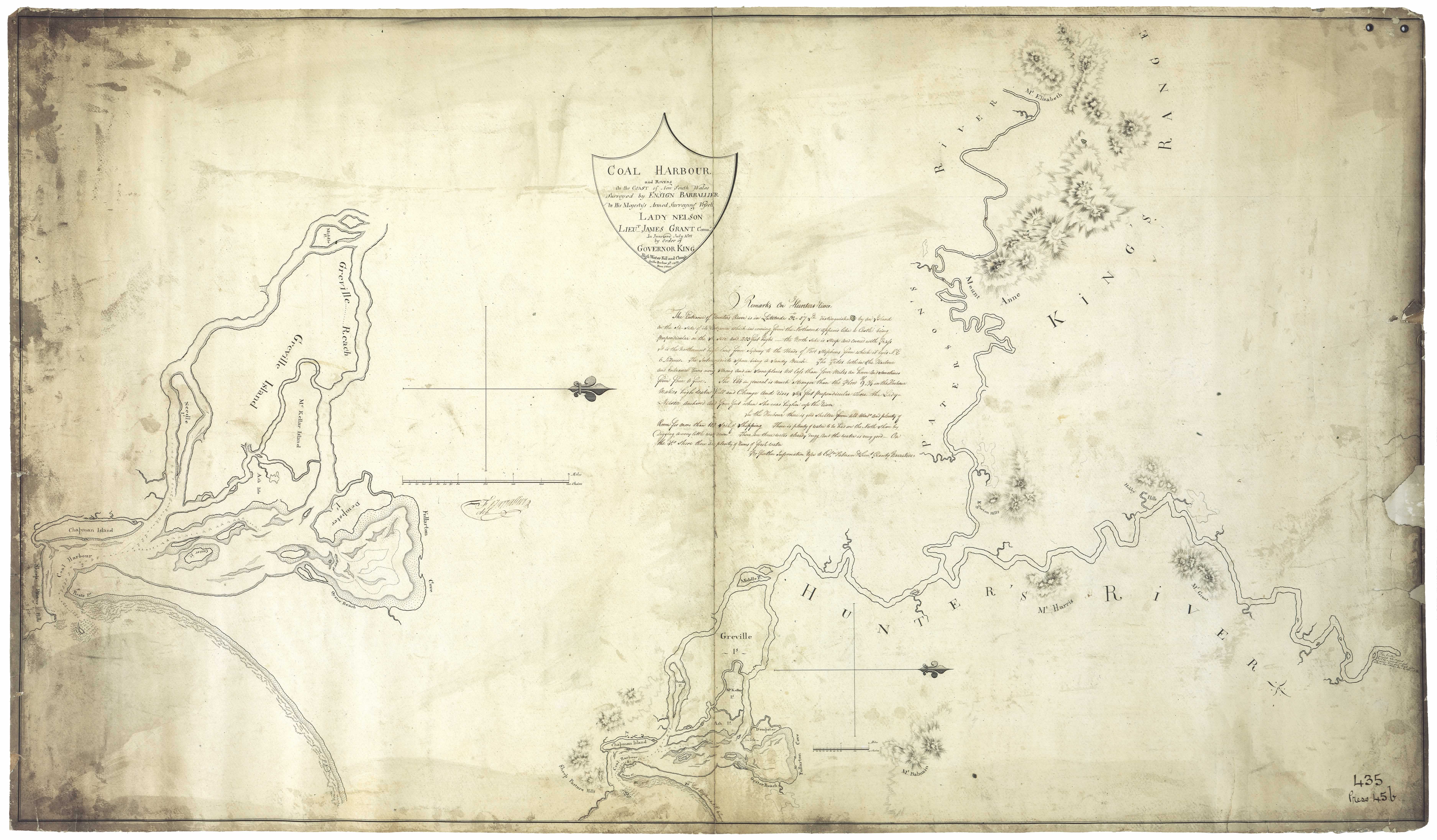
Shepherd's Hill - Newcastle. Named by Lieut. Paterson because it resembled sheep grazing hills in England. Known earlier as Sheep Pasture Hills. (aboriginal name Khanterin) . See Barrallier's 1801 map [31]
Sherwood - situated in Co. of Durham on the Wattle ponds 7 miles from Singleton; estate of Henry Dangar
Sherwood - Allyn River, Paterson district 1852
Shingle splitters Point - Balcolyn, Lake Macquarie. Timber cutters used to make wooden roofing tiles from the casuarina trees that grew here. Sara family
Shortt's Farm - Grant to Francis Shortt - Hunter River
Shortland - After Lieut. John Shorthand who on September 8 1797 Discovered the estuary of the Hunter River and the site of Newcastle while searching for escaped convicts
Siddon's Swamp - Raymond Terrace area . Named for Richard Siddons
Signal Hill - also known as Allan's Hill and Fort Scratchley - Soldiers camped there in 1878 - Newcastle
Silo Hill - Stroud - Underground silos built there in 1841
Simpson's Mount - Co. Northumberland, a high peak in the parish of Lockyer 9 miles S. of Wollombi
Simpson's Pass - situated in Co. Northumberland on the Great North Road about 72 miles from Sydney
Simsville - Stroud district. Named after Canon S. Sim, sometime Incumbent of Stroud [46]
Singleton - After Benjamin Singleton, one of the party that discovered the district on 17 March 1820.Situated at Patrick's Plains in parish of Whittingham, Co. Northumberland on the south bank of the Hunter River
Skellator - Estate of Sir Francis Forbes. Kamilaroi aboriginal name Tamindi
Skye Point - Coal Point, Lake Macquarie - One of the names given to Thelkeld's Estate
Smedmore - Named after a place in Dorset, England. Estate near Wickham, Newcastle. Later known as Maryville after the wife of James Hannell.
Smith's Lake - Said to be named after Peter Smith an assigned convict to surveyor James Ralfe
Snapper Island (or Snapper-hole Island) - An island situated in the county of Northumberland on the river Hunter to the northward of Moscheto Island. Now part of Kooragang
Snapper Island - An island situated in Co. of Gloucester in the harbour of Port Stephens
Snodgrass Bay, Co. Gloucester, small bay on the Myall Lakes
Snodgrass Valley - Also known as No-grass valley. Also known as Twelve Mile Hollow, later became known as Ten Mile Hollow. On the Great North Road (Sir Thomas Mitchell)
Soldier's Beach - near Norah Head
Soldier's Point (Port Stephens) - So named because soldiers were stationed there to intercept runaway convicts on their way from the penal settlement of Port Macquarie to Newcastle. Earlier name Friendship Point [46]
Solodunna - in the district of Liverpool Plains. station of Messrs Smith and Harper
Somersby - Gosford district. - named after a place in Lincolnshire, England [46]
Sophia Creek - Flows into Guangua Creek. Co. Brisbane
Spectacle Island - Small island at the estuary of the Hunter River and east of Moscheto Island . Now part of Kooragang
Spectacle Island - Lake Macquarie
Speer's Point - May be named after William Speer who purchased 1280 acres there in 1870. The aborigines had called the spot Milloba or Biddaba. William Brooks was first granted this land
Spion Kopp - Kurri Kurri district. Named after one of the battle fields of the Boer War in South Africa [46]
Spit Island - Hunter River. First named Needle Island by Lieut. Paterson in 1801
Spit Island - situated in Co. of Northumberland on the Hunter River to the South of Ash Island
Splitter's Creek - Runs into the Page River
Springfield - Galgal area. Upper Hunter
Spring Ridge - Quirindi district (descriptive) [46]
Staffordshire Cottage - Opposite the Church of England East Maitland
St Albans - a town situated on the Macdonald river in Co. Northumberland. Named after the City of St Albans in Hertfordshire, England
St. Aubyns - Estate of William Dumaresq - Upper Hunter
St. Aubyns - Town situated Co. Brisbane on Dartbrook
St. Clair - Singleton district. Belonged to George Loder of Abbey Green
St. Germans Meadow - near Kingdon Ponds - Dangar's Map [29]
St. Heliers - Estate of Henry Dumaresq - Upper Hunter near the confluence of Dartbrook (Kamilaroi aboriginal name Boorumbeelah)
St. Heliers Creek - Weeduran
St. Hillier's Brook, Co. Durham, an eastern tributary of the Hunter River falling into it to the N. of Muswellbrook. [37]
St. Kilda Boarding and Eating House - Watt St. Newcastle 1869. Next door to the Albion Hotel.
St. Ronan's - 18 Bingle Street, The Hill
Stanford - a parish situated in Co. Northumberland; bounded on the N. by the parish of Heddon; on the E. by the parish of Stockrington; and W. by Pokolbin. Cessnock district
Stanford Merthyr - Kurri Kurri district. Named after a place in Wales [46]
Stanhope - A parish situated in Co. of Durham bounded on the N. by Tangorin; on the S. by the Hunter River; on the E. by Wolsingham; and on the W. by Marwood. Singleton district
Steele Street, Newcastle - named after James Steele, Colliery Engineer for the A.A. Co. [3]
Stevenson's Place, Newcastle - George and Robert Stevenson, engineers [48])
Stewarts Brook - Scone district. flows into the Hunter river near Castle Sempill. (Stewards Brook on Dixon's map [30])
Stingaree Point - Dora Creek - Peninsula of land on the south bank of Dora Creek.
Stockade - Newcastle - near the Custom House. Known as No. 3 Stockade 1830s. An amusement hall adjoined the Stockade late 1800's.
Stockrington - a parish situated in County of Northumberland; bounded on the N. by the parish of Maitland; on the W. by the parishes of Stanford and Heddon; and on the E. by the parish of Hexham. Cessnock district
Stockton - Town situated in parish of Stockton, co. of Gloucester opposite the town of Newcastle. In 1797 named Point Kent by Lieut. Shortland. Also called 'Pirates Point' as the result of escaped convicts being shipwrecked on the peninsula in 1800. Burrinbingon or Buringmon, was the Aboriginal name for Stockton meaning a land of plenty with food in abundance.
Stodart Valley - situated in the district of Liverpool plains; watered by one of the tributaries of the Gwydir river.
Stoneybatter - George Hall's run on the Macdonald River
Stony Creek, Co. Northumberland, an eastern tributary of Black Creek crossing the Maitland and Wollombi Road at Bishops Bridge.
Stoney Creek - Early name for Farley
Stoney Creek - Blackalls Park
Stradbroke - Estate of William Munnings Arnold formerly Macquarie Farm. Paterson
Stratford - Gloucester district - Named after Stratford-on-Avon in Warwickshire, England [46]
Strathearn - parish situated in Co. of Brisbane bounded on the E. by Dartbrook; on the S. by Ellis
Strathilsa Estate - Paterson
Stroud - Village named after a place in Gloucestershire, England by Robert Dawson. Situated on the Karuah river. Headquarters of the A.A. Co in 1848
Strowan - Estate of George Bowman and later Robertson family
Stylesgrove - Named after Henry Styles. Also known as The Big Swamp, Hexham.
Sugar Bay - area on Lake Macquarie where a sugar plantation existed. Brightwaters
Sugarloaf Creek - At its junction with Wollombi brook on the Great North Road in the Co. of Northumberland is 92 miles from Sydney
Sugarloaf Creek - Dungog district. Formerly known as Derriga Creek
Sugarloaf Point - On the coast to the north of Port Stephens and near the north end of Myall lake
Sugarloaf - Mount Sugarloaf, also known as Great Sugar Loaf, is a mountain in the lower Hunter Region overlooking the cities of Newcastle, Lake Macquarie, Cessnock and Maitland. Early name for Watagan Mountains
Sugeebag - a branch of Mangrove Creek, Co. Northumberland
Summerhill - Near Wallsend and Plattsburg. Subdivision of J.W. Brook's estate
Summer Hill - Grant to Edward Kealy - Paterson River
Summer Hill Station - neary Wearys Creek - John Single
Susan Gilmore Beach - Newcastle - named for the Susan Gilmore which was wrecked there in 1884
Swamp Creek - flowing into Fishery Creek near Maitland
Swamp Oak - In the district of Liverpool Plains on Swamp-oak creek 70 miles from Murrurundi. Station of Peter Brodie.
Swan Bay - Port Stephens district. Descriptive [46]
Swan Reach - A reach about 1 km long on the Hunter River. Located about 4 km downstream from the junction of Paterson River with Hunter River.
Swansea - After the seaport of that name in Wales by Captain R.H. Talbot one of the pioneers of the shipbuilding trade there who fancied that he perceived some resemblance to the Welsh coal port
Sweetman's Creek - Wollombi - named after William Sweetman, a settler there who married a daughter of Corporal Budd in 1835 [46].
Notes on the Origins and Locations of the Hunter Region has been derived from the following sources
[1] Trove - National Library of Australia
[2] Newcastle Morning Herald 11 December 1954
[3] The Newcastle Sun 2 May 1918
[4] The Newcastle Sun 26 January 1931
[5] The Many names of Newcastle Mulumbinba
[6] The Muswellbrook Chronicle 8 November 1899 ( native names of place from black tracker Jimmy of Muswellbrook)
[7] Lake Macquarie History of Places
[8] Cadell, F.A., Survey of Newcastle, Journal and Proceedings of the Royal Australian Historical Society, 1936
[9] Davies, Noel, Convict Nobbys : the story of the convict construction of Macquarie's Pier and the reconstruction of Nobbys Island
[10] Historical Roads of New South Wales
[11] Keith H. Clouten, Reid's mistake : the story of Lake Macquarie from its discovery until 1890
[12] County Electors in Newcastle 1855
[13] Hunter Estates Comparative Heritage Study
[14] The Dungog Chronicle 6 July 1949
[15] The Scone Advocate 24 July 1894 (Muswellbrook names)
[16] Wingham Chronicle 13 November 1931 (Manning River places)
[17] King Tom's Aboriginal Geography in Memorandum of E.C. Close, in Australian Town and Country Journal, 12 January 1878, p. 8.
[18] Aboriginal names, Australian Town and Country Journal 11 January 1879p. 17
[19] Henry Thomas Ebsworth papers, June 1825-February 1827; with illustration and maps
[20] Horsemen of the First Frontier (1788-1900) and the Serpent's Legacy Front Cover Keith Robert Binney
[21] An Australian Language as spoken by the Awabakal, the people of Awaba, Lake Macquarie, being an account of their language, traditions and customs - Lancelot Threlkeld (many of the aboriginal terms above have come from this source which is probably the language of the lower Hunter tribes)(many of the aboriginal terms above have come from this source which is probably the language of the lower Hunter tribes)
[22] Hunter Living Histories - Ludwig Leichhardt in Newcastle
[23] A geographical dictionary or gazetteer of the Australian colonies ... By William Henry Wells
[24] Placenames as a guide to language distribution in the Upper Hunter - Jim Wafer
[25] Lake Macquarie : past and present
[26] Wangi Wangi Street Names by Clive Read
[27] Forgotten place names of Lake Macquarie - Lake Macquarie Library online
[28] Lake Macquarie: Parish of Awaba, County of Northumberland, Shire of Lake Macquarie. Parish map in 4 sheets and reference sheet: South East Sheet
[29] Map of the Hunter River and its branches by Henry Dangar 1828
[30] Robert Dixon's 1837 Map - Trove
[31] Ensign Francis Barrallier's Map 1801 - Hunter Living Histories
[32] Australian Town and Country Journal 22 November 1873
[33] Procter's Sketch 1841 - Hunter Living Histories
[34] Tegg's Pocket Almanac
[35] Map of Young Wallsend (Edgeworth) showing Salty Creek Recreation Area, c.1920. Scanned from: Road and tourists' map of Lake Macquarie and environs, H. E. C. Robinson Limited, Sydney.
[36] Salty Creek Recreation Area
[37] Geographical Encyclopaedia of New South Wales
[38] Atlas of the settled counties of New South Wales - State Library NSW
[39] Maitland Weekly Mercury 4 July 1896
[40] Empire 3 Dec 1853 Lecture on the Kamilaroi Blacks (Rev. William Ridley)
[41) Israel's subdivision map of Wangi c. 1923. State Library of NSW
[42] Hunter 2000, National Trust of Australia (NSW), 1973
[43] Lauchland, E. S., Homes we Visited - Dumore. Newcastle & Hunter District Historical Society Journal, 1947 p. 39
[44] Boyle's Lower Hunter index, 1801-1883 (Harry Boyle)
[45] Hunter Valley Place Names and their Meanings, Newcastle Library, Archived 14 June 2011 at the Wayback Machine
[46] Toponomy: Place Names of New South Wales: Their Origin, Meaning and Locality, compiled by J. Carlos W. Stretch
[47] Rediscovering the Coquun: towards an environmental history of the Hunter River. Address given at the River Forum 2000 at Wyndham Estate, Hunter River; by Glenn Albrecht PhD, Senior Lecturer in Environmental Studies, The University of Newcastle
[48] How Many Inventors? Russell Rigby, Hunter Living Histories, 10 October 2017
↑