Notes on the Origins and Locations of Place Names
Newcastle - Lake Macquarie - Hunter Valley
D
Dagworth - Grant to Captain Thomas Valentine Bloomfield, Maitland. County Northumberland. A tract of flat and partly swampy land situated on Wallis Creek. [37]
Dalkeith - Town in Co. Bligh. Near Cassilis. Near the Krui River. Named after a place near Edinburgh, Scotland [46]
Dalswinton - Estate of Peter Cunningham - Upper Hunter
Dalwood - Co. Northumberland near Maitland. Estate of George Wyndham
Dandrie - district of Liverpool Plains. Station of James Evans
Dangar Chambers - In 1892 Dangar Chambers in Bolton Street was built, providing 16 professional suites. In 1948 the building was sold to Legacy by the estate of Albert Dangar, and renamed Legacy House
Dangarfield Farm - Dalwood
Dangarfield - N. E. Aberdeen. Named after Henry Dangar, early pioneer and surveyor of the A. A. Co., [46]
Dangar Park - Mayfield - The 11 acres for this park was part of the Dangarfield Estate and was dedicated by Albert Augustus Dangar (4th son of Henry Dangar) to Waratah Council for use as a park in February 1910 https://trove.nla.gov.au/newspaper/article/137448472
Dangar Street - Wickham - May have been named for Albert Augustus Dangar who was born two years after the Myall Creek Massacre. A. A. Dangar subdivided his Wickham estate land c. 1870s. Albert Dangar also built the Great Northern Hotel and donated land for the Wickham School of Arts. He invested a great deal of money in Newcastle's development
Dano Range - district of Liverpool Plains on the Mooki river 43 miles from Murrurundi. Station of Samuel Clift
Daragen - Aboriginal - Morpeth Swamps (1860s)
Darby Street Cook' Hill - Originally Lake Macquarie Road. Named after A.A. company surveyor Lieut. George Darby of 45th regt., who first laid out town allotments on the Company estate. [3]
Dark Creek - early name for part of Jesmond
Darlington - Parish in Co. Durham. Township adjoining Singleton in parish of Auckland on the Hunter River. Fertile agricultural district. [37]
Dartbrook - a stream rising on the Liverpool range near Mount Towarra, Co. Brisbane. It runs through the county and flows into the river Hunter. Kamilaroi aboriginal name Coomawidyera. Tributaries Petwynne Valley, Middle and Sharke's Creeks. [37] Named after the famous river in Devon, England [46]
Dartbrook House - Owned by Thomas Simpson Hall
Davies Creek - Co. Brisbane. 209 mils N Sydney. Nearest railway station in 1893 Aberdeen. [37]
Davis Town - Co. Northumberland. A postal village 61 miles N of Sydney. [37]
Dawson's Hill - Singleton district. Named after Robert Dawson, the first Agent of the A. A. Co., to whom a grant of this area was made in 1828 [46]
Dawson Street Cooks Hill - named after Robert Dawson, commissioner of A.A. Co. [3]
Deadman's Creek - a small eastern tributary of Black Creek. [37]
Deard's Farm - Paterson
Deega Estate - Lake Macquarie - A grant to A.W. Scott. Killingworth
Deep Creek - Co. Gloucester. 356 miles N. of Sydney. [37]
Deep Creek - Flowing into Black Creek near Cessnock
Deep Water - district of New England. Station of Messrs and A. Windeyer
Deepwater Estate - Cockle Creek c. 1884
Deerubbbun River - the native name of the Hawkesbury River
Dellhurst - Singleton district
Delungara - district of Liverpool Plains. Hall's station
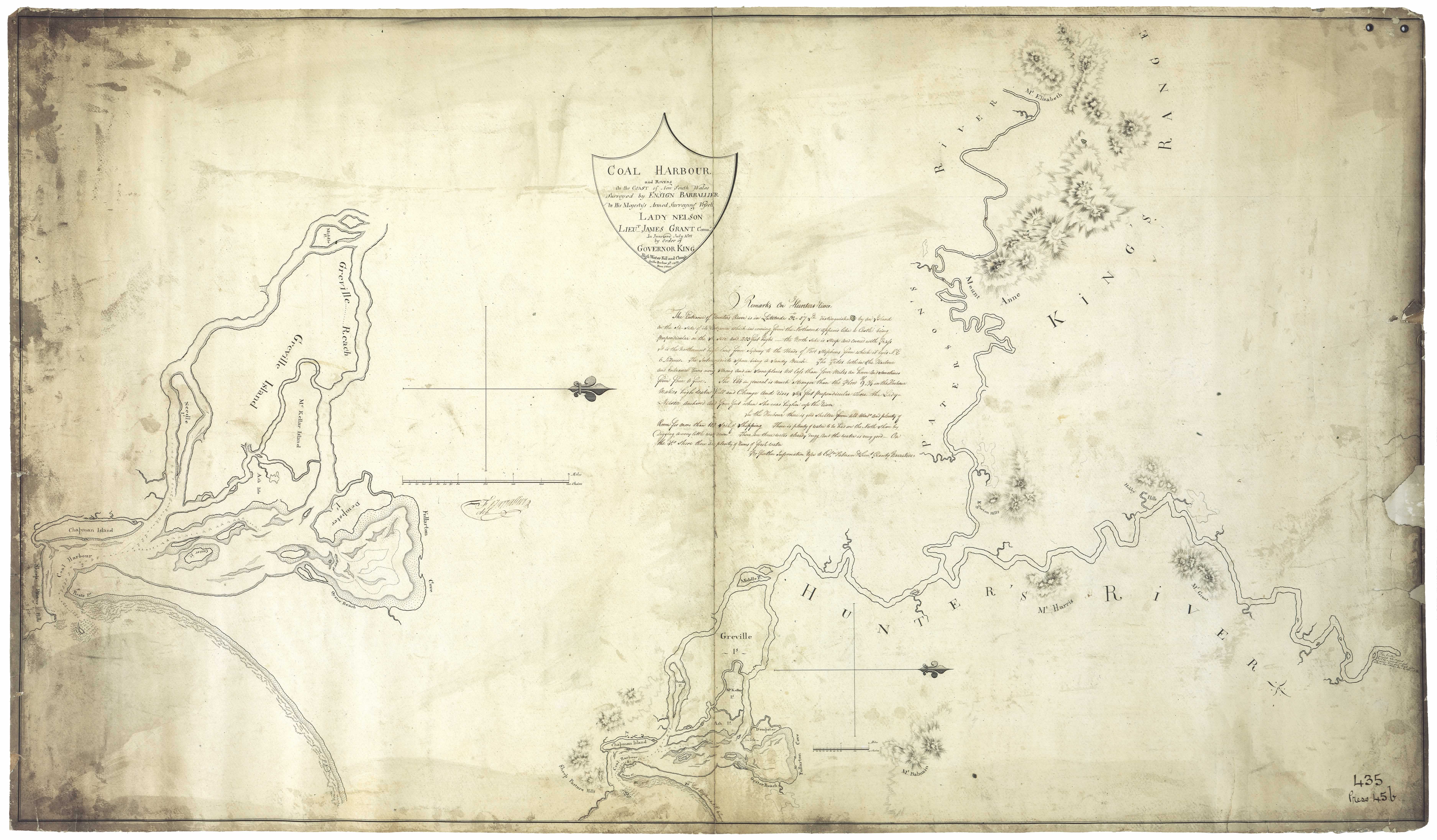
Dempsey Island - Island in the Hunter River situated between Ash Island and Moscheto Island
Dempster Island - as above - see Barrallier's 1801 map
Denison Street Hamilton - named after Sir William Thomas Denison, an early Governor of NSW
Denman - After Lord Thomas Denman (1779 - 1854), Lord Chief Justice of England, grandfather of Lord Denman, Governor General of Australia 1911 - 14) Situated Co. Brisbane. Near Wollemi National Park
Dennis's Dog Kennel - Co. Northumberland near the Great North road 78 miles from Sydney. See Dixon's map. Near Mt. Macquoid.
Deptford - Raymond Terrace - named after a suburb of London by William Lowe pioneer ship builder
Derahbambah - (a.n.) - also Punte or Puntei. Land on which Ebenezer was built - Toronto Lake Macquarie
Derraderra - district of Liverpool Plains . William Cox's station
Derridgerie - S. W. Cassilis. Rough bushes that grow in creeks (aboriginal meaning) [46]
Derriga - a small stream Co. Durham. Runs into the Myall. Later known as Sugarloaf Creek.
Devil's Backbone - On the Great North Road
Dewey Point - Toronto, Lake Macquarie
Dewrang - N. Stroud. Aboriginal meaning - High in mountainous country [46]
Diamond Drill Point - opposite South Beach estate in 1931, south of Nords Wharf
Diega Flat - West of Trialba House towards Wallsend. Co. Northumberland. A tract of flat country lying on the NW of Lake Macquarie and on the banks of Cockle Creek. [37]
Digby Grove - Quorrobolong. Estate of Achilles Daunt
Dilgoor - Aboriginal name. Junction of Page and Hunter Rivers [24]
Dilgry - N. W. Gloucester. Aboriginal meaning rocky boulders [46]
Dingadee - Aboriginal meaning - Good place for game [46]. Estate of John Hooke's 4 miles from Dungog
Dinindarine - district of Liverpool Plains on the Manning River. Station of Otto Baldwin
Diniwarindi - Otto Baldwin's run near Manilla. Later known as Durham Court.
Dirra - district of Liverpool Plains. O'Neil's station
Dobell Park - Wangi in honor of Sir William Dobell, artist
Dockyard - name given to part of Millers forest where John Korff's shipyard was situated
Doggrel Creek - Flows into the Williams River
Doghole Farm - Close to Minmi, part of James Muir's land
Doona - W. Quirindi - aboriginal meaning an ironbark tree [46]
Donnybrook - Estate of Beresford Hudson near Mount Elizabeth several miles from Lamb's Valley
Donny Brook Inn - near Singleton
Dooralong - Wyong - Aboriginal meaning a smoky plain [46]
Dooreldoorel - a creek situated on Co. Gloucester flowing into the Williams River
Dooribang / Doorabang - Aboriginal name for the Williams River
Doree - Co. Northumberland, a post office, 126 miles N of Sydney. [37]
Doreet - A creek situated in Co. Gloucester flowing into the Williams River
Doribank - Estate on the Williams River. Offered for sale by Archibald McLeod in 1851
Dorigo Creek - small stream flowing into the Myall river (Teggs:1842)
Dory (Dora) A creek in Co. Northumberland on which stands the town of Newport. Flows into Lake Macquarie. (aboriginal meaning Doree Doree meant a creek running to the lake). Also known as Nekinda; also Dorri Brook. 81 miles N of Sydney. Aboriginal meaning also sleepy, sluggish, no current [46]
Doughboy Hollow - district of Liverpool Plains 5 miles from Murrurundi; the station of Dr. Gill
Dowadee Island - Port Stephens (1826)
Dowling's Range - near Hungry Flat (see Dixon's map). Co. Northumberland - a part of the Hunter Range lying between Snodgrass Valley on the S and McDonald's Flat on the N. [37]
Downgimbie - (Aboriginal meaning- mussel ground) - ?Muswellbrook [24]
Doyalson - a name derived from the names of two early pioneers of the district Doyle and Allison [46]
Doyles Creek- A creek situated in Co. Hunter. Empties into the Hunter River. Cyrus Matthew Doyle
Drew's Creek - flows into Wollombi Brook
Drilldool - district of Liverpool Plains on the Namoi River. Station of Edward White
Drummond Range - a range of mountains situated in district of Liverpool Plains. South of the Gwyder river
Duckinfield House - House belonging to John Eales - Hunter River
Duck Hole - old name for Pindimar
Duck Hole Estate - Also known as the Big Swamp. Also known as Chevelly. Part of the Millers Forest area.
Duck Island - Island in the Hunter River below confluence of Hunter and Paterson Rivers. [31] Barrallier's 1801 map
Duck River Farm - Farm belonging to Francis Moran
Dudley - named after a place in Worcestershire, England [46]
Duff's Pass - Co. Hunter, a crossing place over Doyle's Creek from Singleton to the neighbourhood of Dabee.
Duguid's Hill - Co. Northumberland, a hill about 2 miles SW of Lochinvar. [37]
Dulcamah Estate - At Whittingham. First owned by Robert A. Rodd who sold it to Duncan Forbes Mackay
Dulwich - Estate of James Glennie. Situated on Falbrook, Co. Durham
Dumaresq St. Newcastle - Named after Col. Henry Dumaresq who succeeded Sir William Edward Parry as Commissioner of A.A. Company. [3]
Dunbar's Creek - Co. Durham. 188 miles N of Sydney. 12 miles from Muswellbrook. [37]. Named after Samuel Dunbar an early settler in the district [46]
Duncans - a creek in the district of Liverpool Plains. On this stream is the station of J.T. Armytage and Co.
Dunedoo - Cassilis district. Aboriginal meaning - small feet [46]
Dungaleer - district of Liverpool Plains. Emanuel Hungerford's station
Dungee - Situated in district of McLeay on Dungee Creek. Station of Alexander Gammack
Dungog - Clear hills (aboriginal meaning). Tunkok (aboriginal name). Gringai tribe. Situated Co. Durham on the Williams River.
Dungowan - district of Liverpool Plains. Run belonging to Isaac Haig, also Hamiltons station. 16 miles from Tamworth
Dunheved - Vineyard near Paterson in 1865 owned by Mr. Steers
Duninald - Estate belonging to William Dun - Paterson River
Duns Creek - near Duninald
Dunmore - Named by Andrew Lang, the original grantee in 1822, after his mothers maiden name - Paterson
Dunmore House - Situated on the estate of Dunmore
Dunolly - Singleton district
Dunvegan Estate - Upper Paterson. Named for a place in the Isle of Skye, Scotland [46]
Dural - district of Liverpool Plains. Station of John Wild
Durham - County of NSW. Towns include Paterson, Muswellbrook, Seaham, Clarencetown, Dungog, Hinton, Gresford, Merton and Camberwell.
Duri - Estate at Broke
Durren Durren - Wyong district - Aboriginal meaning - dry ground out of flood reach [46]
Dusodie - Dungog district [46]
Dyrring - Parish in the Co. of Durham bounded on the W. by Brought; E. by Mirannie; and S. by Sedgefield. In this parish is situated Mount Dyrring, a peak of the Mount Royal Range under which is Falbrook
Notes on the Origins and Locations of the Hunter Region has been derived from the following sources
[1] Trove - National Library of Australia
[2] Newcastle Morning Herald 11 December 1954
[3] The Newcastle Sun 2 May 1918
[4] The Newcastle Sun 26 January 1931
[5] The Many names of Newcastle Mulumbinba
[6] The Muswellbrook Chronicle 8 November 1899 ( native names of place from black tracker Jimmy of Muswellbrook)
[7] Lake Macquarie History of Places
[8] Cadell, F.A., Survey of Newcastle, Journal and Proceedings of the Royal Australian Historical Society, 1936
[9] Davies, Noel, Convict Nobbys : the story of the convict construction of Macquarie's Pier and the reconstruction of Nobbys Island
[10] Historical Roads of New South Wales
[11] Keith H. Clouten, Reid's mistake : the story of Lake Macquarie from its discovery until 1890
[12] County Electors in Newcastle 1855
[13] Hunter Estates Comparative Heritage Study
[14] The Dungog Chronicle 6 July 1949
[15] The Scone Advocate 24 July 1894 (Muswellbrook names)
[16] Wingham Chronicle 13 November 1931 (Manning River places)
[17] King Tom's Aboriginal Geography in Memorandum of E.C. Close, in Australian Town and Country Journal, 12 January 1878, p. 8.
[18] Aboriginal names, Australian Town and Country Journal 11 January 1879p. 17
[19] Henry Thomas Ebsworth papers, June 1825-February 1827; with illustration and maps
[20] Horsemen of the First Frontier (1788-1900) and the Serpent's Legacy Front Cover Keith Robert Binney
[21] An Australian Language as spoken by the Awabakal, the people of Awaba, Lake Macquarie, being an account of their language, traditions and customs - Lancelot Threlkeld (many of the aboriginal terms above have come from this source which is probably the language of the lower Hunter tribes)(many of the aboriginal terms above have come from this source which is probably the language of the lower Hunter tribes)
[22] Hunter Living Histories - Ludwig Leichhardt in Newcastle
[23] A geographical dictionary or gazetteer of the Australian colonies ... By William Henry Wells
[24] Placenames as a guide to language distribution in the Upper Hunter - Jim Wafer
[25] Lake Macquarie : past and present
[26] Wangi Wangi Street Names by Clive Read
[27] Forgotten place names of Lake Macquarie - Lake Macquarie Library online
[28] Lake Macquarie: Parish of Awaba, County of Northumberland, Shire of Lake Macquarie. Parish map in 4 sheets and reference sheet: South East Sheet
[29] Map of the Hunter River and its branches by Henry Dangar 1828
[30] Robert Dixon's 1837 Map - Trove
[31] Ensign Francis Barrallier's Map 1801 - Hunter Living Histories
[32] Australian Town and Country Journal 22 November 1873
[33] Procter's Sketch 1841 - Hunter Living Histories
[34] Tegg's Pocket Almanac
[35] Map of Young Wallsend (Edgeworth) showing Salty Creek Recreation Area, c.1920. Scanned from: Road and tourists' map of Lake Macquarie and environs, H. E. C. Robinson Limited, Sydney.
[36] Salty Creek Recreation Area
[37] Geographical Encyclopaedia of New South Wales
[38] Atlas of the settled counties of New South Wales - State Library NSW
[39] Maitland Weekly Mercury 4 July 1896
[40] Empire 3 Dec 1853 Lecture on the Kamilaroi Blacks (Rev. William Ridley)
[41) Israel's subdivision map of Wangi c. 1923. State Library of NSW
[42] Hunter 2000, National Trust of Australia (NSW), 1973
[43] Lauchland, E. S., Homes we Visited - Dumore. Newcastle & Hunter District Historical Society Journal, 1947 p. 39
[44] Boyle's Lower Hunter index, 1801-1883 (Harry Boyle)
[45] Hunter Valley Place Names and their Meanings, Newcastle Library, Archived 14 June 2011 at the Wayback Machine
[46] Toponomy: Place Names of New South Wales: Their Origin, Meaning and Locality, compiled by J. Carlos W. Stretch
[47] Rediscovering the Coquun: towards an environmental history of the Hunter River. Address given at the River Forum 2000 at Wyndham Estate, Hunter River; by Glenn Albrecht PhD, Senior Lecturer in Environmental Studies, The University of Newcastle
[48] How Many Inventors? Russell Rigby, Hunter Living Histories, 10 October 2017
↑