Notes on the Origins and Locations of Place Names
Newcastle - Lake Macquarie - Hunter Valley
A
Aberglasslyn. Co. Northumberland. In 1893 a postal receiving office 123 miles N. of Sydney with mail twice a week. The nearest railway station West Maitland 6 miles on the northern line. A rich rural district on the south bank of the Hunter [37]
Aberglasslyn House - Sandstone house overlooking the Hunter River. Built for George Hobler in 1840. 3 miles from W. Maitland
Abbey Green - Co. Northumberland. Estate of George Loder on the Hunter River near Singleton. Also owned by Alexander Warren and Archibald Mossman. In 1893 described as a small settlement on the banks of the Hunter [37]
Abbotsford - Village near Wallalong (44)
Abbott Street, Dungog - after early settler in the region (Historical Notes on Dungog 01.11.1979 [45])
Abbott Street, Wallsend - After Mr & Mrs Abbott, first people to live in the street. (Wallsend Public School Centenary 1862 - 1962.[45])
Abel Street, Wallsend - After Thomas Abel, Town Clerk, Plattsburg, 1877-1915, Mayor of Wallsend 1919. (Wallsend Public School Centenary 1862 - 1962 [45])
Aberdare - Cessnock district
Aberdeen - Aboriginal name Moonbil. Co. Brisbane. In 1828 Thomas Potter McQueen was granted 10,000 acres between Scone and Muswellbrook. He named this small township Aberdeen after his friend George Gordon, 4th Earl of Aberdeen. In 1893 money order, telegraph offices and govt savings bank. A railway station on the northern line. The district is agricultural and pastoral with some rich flats of cultivation ground [37]
Abernethy - 8 km S.E. from Cessnock. Named after a Scottish mining town [46]
Aboriginal Grant - former 10,000 acre grant - for location {see Dangar's 1828 map [29]}. Wahrah
Abroi - N. Wollombi - a big mountain near blackfellow's home (indigenous) [46]
Adams Green - Also Adams Flat or Black Adams Flat; after Isaac Adam White an Aboriginal man who lived there
Adams Peak - Co. Northumberland. Situated on the W. bank of the Wollombi Brook in parish of Dalton near the junction of Drew's Creek in the Hunter Range [37]
Adams Street, Adamstown - Former name for Belmore Street from Lockyer Street to the end. (Gov Gaz No 32 Folio 981 24.02.1939 [45])
Adams Street, Merewether - After Thomas Adam, Town Clerk, 1903 - 23. (Dixon,J; History of Merewether [45])
Adamstown - Named after Surveyor Thomas Adams, who surveyed the town in 1869. In 1893 a municipal district, governed by eight aldermen and a mayor, situated in parish of Newcastle. Coal mining. Population 2000 [37]
Adamstown Road, New Lambton - Early name for portion of St James Road between Stormwater Channel and Mackie Avenue. (NCC Planning Department [45])
Adelaide Street, Raymond Terrace - Named after the wife of King William the Fourth. (Hunter, C: History and Heritage [45])
Aelaong - Co. in Northumberland bounded on North by Pokolbin
Ahalton Farm - In 1829 James McClymont's farm on the Hunter River adjoining Nelson's Plains. Later owned by Henry Carmichael
Airdrie - North of Paterson - named after a place in Lanark, Scotland [46]
Ajax Avenue, Maryland - After a famous racehorse in keeping with the fact that the area was the former Wallsend Jockey Club's racecourse. (Newcastle Sun 28.05.1976 [45])
Albert Street, Lambton - In honour of the Prince Consort (Lambton Public School Centenary Brochure [45])
Albert Street, Warners Bay - Bonarius family names and named after the Auctioneer who subdividied portions of the land. [45]
Albion Farm - 300 acres owned by John Tucker junior at Patterson's Plains 1823
Albion House - Store belonging to Edward Taylor near the Long Bridge, West Maitland
Albuera - Drummond Mountain range Liverpool Plains. Named by Captain Forbes of 39th Regt.,
Alder Park, New Lambton - After Ald Alder who had taken interest in the New Lambton South School and the work he had done for the New Lambton South Parents & Citizens Association.( NMH 29.07.1953 [45])
Alderley Creek - Stroud.
Alderley House - situated on Bucketts Way halfway between Stroud and Booral. Built c. 1831. Sir W. Edward Parry's wife Isabella was born at Alderley, Cheshire, the estate of her parents Lord and Lady Stanley (Chadban,J: Stroud and the A.A.Co. [45])
Alderley Stables - Established c. November 1831 by Sir Edward Parry near Stroud.
Alfred Street, Georgetown - Former name for Asher Street between Moate Street and Christo Road (NCC Planning Department [45])
Alfred Street, Newcastle - After Duke of Edinburgh [45]
Alfred Street, Waratah - From Mr T. A. Braye (A - Alfred) prominent citizen, churchman and alderman. Mayor 1902,1903 (Waratah Public School Cent Book [45])
Aliceton - Early settlement on the opposite side of the Karuah River to the current settlement of Karuah. (Engel, B: Tea Gardens - Hawks Nest p45 [45])
Alison - S.E. of Dungog - named after the Alison family, early settlers in the district[46]
Allandale - After place in Scotland. Grant to Captain Alexander Anderson - Co. Northumberland. Upper Hunter River. In 1893 a railway station on the northern line, post office. 126 miles N of Sydney. [37]
Allandale - parish of NSW bounded N. by Branxton; S by Pokolbin; W. by Rothbury. Cessnock district.
Allan's Hill - Newcastle - named after the Harbour Master Mr. Allan who resided there (1876); also known as Signal Hill; also known as The Sand Hills - Soldiers camped there in 1878
Allan & Don Lawrence Field, Thornton - In honour of two gentlemen who worked tirelessly for the Thornton district, particularly in the development of the district. (Maitland Mercury 18.07.1988 [45])
Allworth - Small village 60 km north of Newcastle. Crystal Creek runs through it
Alworth Street, Merewether- After Edward Alworth Mitchell Merewether. (Dixon,J; History of Merewether[45])
Allynbrook - Co. Durham. Named by early settlers after places near the Welsh border namely Allyn. (Back to Gresford Centenary Celebrations Book [45])
Allyn, Mount - Co. Durham. Situated 16 miles N of the village of Eccleston; is a peak of the Mount Royal Range at the head of the Allyn River. - [37]
Allyn River - Co. Durham. Falls into the Paterson River
Alnwick - Parish in Co. Northumberland. Bounded on N. and E. by the Hunter River; W. by Maitland and S by Hexham. Later known as Cock-a-Dingy. Named after a place in Northumberland England [46]
Alpha Nursery - Lake Macquarie Road opposite St. John's Church, Newcastle 1860s
Althorpe - Parish in Co. Durham bounded on N. by Vaux; W. and S by Hunter River and E. by Wynn.
Amboise - 2,000 acre property that stretched from the coast between Wamberal and Terrigal Lagoons, all the way to Erina Creek. Estate of Willoughby Bean; David Maziere and Henry Donnison
Amersham - Cardiff/Glendale - Early name for Joseph Weller's land (1830's)
Anderson's Hill - Belmont. Named after John Anderson Angora Heights - Teralba; also known as Billy Goat Hill Anley's Creek - Creek below Dungog cemetery - named for Ferdinand Anley who held a grant further up. Later known as Cangon Creek.
Anambah - Estate of George Cobb
Andrew's Corner - Cessnock
Andrew Roy Street, Raymond Terrace - Believed to be named after workers on James King's estate. (Hunter,Cynthia: History and Heritage[45])
Angora Heights - An area at Teralba formerly known as Billy Goat Hill.Said to have got the name from the large herds of white goats that grazed there. (NMH 15.07.1971 [45])
Anlaby Street, Maitland - After Anlaby's Inn, Morpeth
Ann Street, Mayfield - Braye Street from Rawson to Nile Streets. (NCC Planning Department [45])
Ann Street, Waratah - Earlier name for the portion of Adelaide Street from Leonora Parade to Coronation Street. (Gov Gaz 25.09.1917 [45])
Anna Bay - Derivation of Hannah Bay, named in memory of a boat Hannah, which was alleged to have been wrecked there [45]
Annandale - Estate of David Maziere - Hunter River - later Dalwood owned by George Wyndham
Annandale - House built by Major Edward Johnston - Paterson
Annasdale - Branxton - Dangar's Map
Anne Fenley Lookout - Small rest area east of Newcastle Bowling Club on the corner of King Edward Park. Named in recognition of contribution to the city by a prominent citizen (NCC Business Paper 26.09.00 [45])
Antiene - S. Muswellbrook - named by R. D. Wallace Antrim after his father's place in Ireland but owning to faulty writing the name was made out to be Antiene [46]
Anvil Creek - A small tributary of Black Creek flowing through the village of Greta. Known as "Farthings" to a miner 80 years ago due to the fact that Alexander Farthing opened the Anvil Creek Coal Mine. Situated 32 miles from Newcastle. NMH 17.07.1950 [45]
Anzac Parade, Cooks Hill - After ANZAC. Subdivied in the Gallipoli year 1915. (Cooks Hill Walk Trip. Fredman,L.F. / Newcastle Streets Folder [45])
Anzac Street, Muswellbrook - To record the events of W.W.1. Named when a war service loan enabled the subdivision to take place. (NMH 11.12.1976 [45])
Apex Park, Singleton - Honours the Service Club benefactor. (Singleton Municipality & Shire 1866 - 1991 [45])
Apple Tree Flat - situated at Jerry's Plains
Apple Tree Flat - early name for Killingworth
Arbuthnot Valley - Liverpool Plains. Low lying flat on the E side of Warrabungle Range. [37]
Arcadia Park (Wolfe St. Reserve, included in King Edward Park) Named after Arcadia, U.S.A. - sister city (NMH 07.05.1978 [45])
Arcadia Vale - Originally named Kirkdale after early settler Joseph Kirk. Name given to area by Hely family stemming from Greek mythhology meaning an ideal rustic paradise [45]
Archer Crescent Reserve (Merewether) - Named after Ald. J. Archer (Dixon,J:History of Merewether [45])
Archerfield - Grant to George Bowman in 1825 at the Hunter River opposite the junction of Falbrook
Arden Hall Estate - Estate of John Dowe - 12 miles from Scone. Arden Hall named after a place in Essex, England north of Tilbury [46]
Ardessier House - The house of Alexander Munro, first Mayor of Singleton.
Ardglen - Murrurundi - named after a place in Scotland [46]
Argenton - Named because of the silver-lead treated at the Sulphide Works nearby. "Argent" is French for silver and "ton" a shortened form for town (Lake Macquarie Past & Present [45])
Aries Way Reserve (Elermore Vale) A number of streets in Elermore Vale are named after star constellations. (Parks MDS A/C:NPMD - 04.01.1988 [45])
Armstrong Park, Lambton - Takes its name from its location on Armstrong St. which is named after Thomas Armstrong former mayor of Newcastle & state member of parliment (NMH 19/04/1961 p. 2 [45])
Armstrong Street, Lambton - In honour of Thomas Armstrong, a former Lord Mayor of Newcastle and for a time member of State Parliament. (Lambton Public School Centenary Brochure [45])
Arnott's Steam Biscuit Factory - Union Street Newcastle built in 1889
Arabella estate - near Underbank Dungog district
Arnold Street, Carrington - After Hon William Munnings Arnold Minister for Public Works 1860 who drowned in floods at Stradbroke, Paterson, N.S.W. (Carrington Folder - Streets [45])
Arnott Street, Cooks Hill - After William Arnott who owned several lots of land in the area. (Archives of Business and Labour ANU [45])
Arnott's Paddock, Cooks Hill - After William Arnott who owned several lots of land in the area, and who rented the paddock from the A.A.Co. (Archives of Business and Labour ANU [45])
Arrarrowine - Run belonging to John Robertson - Liverpool Plains
Arrowfield - George Bowman's grant. Muswellbrook district
Arthur, Mount. Co. Durham. A high mountain a few miles S of Muswellbrook. [37]
Arthur Park - Broadmeadow - Named after J.A. Arthur, Mayor of Adamstown Parks (MDS A/C:NPMD - 04.01.1988 [45])
Arthur Street, Merewether - Named after Dean Arthur Edward Selwyn (Dixon,J; History of Merewether [45])
Arundinetum - Mirrabooka - The name of Joseph Marshall's property at Sugar Bay and site of the sugar processing plant
Arunta Street in the subdivision called the "Assault Basin" named after vessels which either operated from Port Stephens or escorted the naval boats from HMAS Assault on active duty in the Pacific and South-East Asia during W.W.2 (Armstrong, J:Yaccaba and Tomaree [45])
Ash Island - Named by Colonel Paterson on June 17, 1801, on account of 'a very excellent wood similar in quality to ash, and grows as large'. Estate of Alexander Walker Scott. Also known as Glandville or Greville Island. Situated in the lower part of the Hunter River 3 miles from Newcatle and opposite Hexham. In 1893, 5 miles in length and 2 miles in width. This island together with Mosquito and som other small islands divide the stream of the Hunter into two parts called the North and South Channels, the former being th one used by steamers. [37]
Asher Street, Georgetown - From Mr. R. Asher, Business man and land owner of Georgetown. Originally called Elizabeth Street after a daughter of the Moate family. (Waratah Public School Cent Book. [45])
Ashton - homestead on Hunter River, Parish Ravensworth - Dangar's Map [29]
Atunga - Liverpool Plains. Co. Parry. Bosley's station. In 1893 a post office with daily mail from Sydney. Nearest railway station Tamworth.
Auchentorlie Estate - Residence of Police Magistrate Thomas Cook at Dungog. Named after a place near Dumbarton, Scotland [46]
Auckland - Co. Durham, a small agricultural village a short distance to the W of Singleton at the junction of Rix's Creek. [37]
Auckland Street, Newcastle - Named after the Earl of Auckland who was b. 1784; holder of position in British Government. (F. A. Cadell (Newcastle Streets folder) [45])
Avenue of the Allies (Tanilba Bay) To commenorate the W.W.1 events in Tanilba Bay by developer Halloran (Armstrong,J:Yaccaba and Tomaree [45])
Avoca Point - Co. Northumberland six miles from E. Gosford. Avoca Named by John Moore in 1830 after a famous beauty spot in Ireland. Meaning "the meeting of the waters".[45]
Avon River - Co. Gloucester. [37]
Avondale - derived from the Welsh word "afon" which means river or water [46]
Awaba - A plain surface. Aboriginal name for Lake Macquarie. Co. Northumberland. Town in Lake Macquarie shire. In 1893 a railway station on the Sydney and Newcastle line. [37]
Awabakal - 'Gal' or 'Kal' means 'the people'
Awaba Park - Booragul
Awaba Park Estate - Marmong Point (NMH 8 June 1878)
B
Baan Bah or Baamba - Grazing Run of Sir John Jamison on the Namoi River
Babinboon - Liverpool Plains between the Conadilly and Gaora rivers
Back Channel - Local name for the South Channel between Moscheto Island and Black Wharf which was situated at the end of Ingall Street, Mayfield. (Stockton Historical Soc Jour Vol1 no 5 p 2.[45])
Back Creek - Also known as Saxby. Barrington Gold field (1879). Early name for Copeland. (NMH 04.03.1879. & Hartley,D:Settlers of the Big Swamp p 121 [45])
Baden Powell Hotel - Watt-street, Newcastle (Find Location)
Baelpin - Patrick Plains district
Baerami - A spear thrower. (aboriginal meaning). Durham Co. Located in Muswellbrook shire. In 1893 a post office; mail 3 days a week. Nearest railway station Muswellbrook 30 miles away on the northern line. [37]
Bagman Creek - Early name for Four Mile Creek. (Boyle's Index to Lower Hunter. [45])
Bahtabah - Belmont - name given by Rev. Threlkeld to his mission house at Belmont; Aboriginal for 'hill by the lake'
Baiami Caves - Situated at Milbrodale, the estate of Rev. Richard Hill. Eighty-hectare site containing rock shelters with many signs of Aboriginal occupation
Baileys Bluff - Morisset Park - named after early landowner Bert Bailey
Bailey's Orchard - 235 Scenic Drive, Merewether (Find Location)
Baker's Creek. Co. Gloucester, a small tributary of the Belbora Creek. [37]
Balbee D'Outre-Mer - 29 High-street, The Hill (Find Location)
Balcolyn - Scottish origin. Suburb of Lake Macquarie
Ballarat (South Wallsend) - Subdivision by Newcastle Wallsend Coal Co. Perk Street is listed as being in this subdivision. (AB962 Wallsend Council Minutes 09.07.1925 Motion 306[45])
Ballast Ground - An area at Stockton reclaimed using the stone ballast discharged from sailing ships into the harbour up to the 1860's. (Callen,T:Bar Safe [45])
Ball Brothers building - 805 Hunter-street, Newcastle (Find Location)
Balleroo - Liverpool Plains. Station of Messrs Scott and Pitt
Ballickerra - Grant to Lieut. William Caswell in 1830
Ballindo - or Dampton Farm - Dartbrook, Upper Hunter in 1846
Balley Hill - Bolwarra. A fight amongst the native tribes took place in 1835
Balmoral - Scottish origin. Suburb of Lake Macquarie
Banana Gardens - Also known as Dartmouth. Near Catherine Hill Bay 1870
Banbar - a river in district of Liverpool Plains. Branch of the Namoi
Bando Plains - Station of W. Alison Liverpool Plains
Bandon Grove - Named by Mr. Kingston after Bandon in County Cork, Ireland. Co. Durham. In 1893 a postal township; mail 3 times a week. Morpeth nearest railway station. Situated on the E. bank of the Chichester River at its junction with the Williams. Nearst town Dungog 7 miles. - [37]
Band Rotunda - King Edward Park, Newcastle (Find Location)
Banfield - Co. Gloucester. An agricultural settlement on the Williams River 7 miles N of Clarence Town. [37]
Bangulgully - Liverpool Plains. Station of James Evans
Bank Arcade (Maitland) - Renamed when the Rural Bank bought the premises occupied by Fosseys and a newer title created. (MM 03.04.1962 [45])
Bank Corner - 744 Hunter-street, Newcastle (Find Location)
Bank Corner Cafe - 681b Hunter-street, Newcastle (Find Location)
Bank Hotel - 235 - 237 Hunter-street, Newcastle (Find Location)
Bank Hotel - 78 Melbourne-street, East Maitland (Find Location)
Bank Street (Merewether) -Dedicated to Merewether Council in 1886 by the Merewether Estate (Dixon,J: History of Merewether [45])
Bank Street (Waratah) - Earlier name for Dawson Street. (NCC Planning Department [45])
Banks - Old Banks and New Banks - Soon after European settlement began in 1818, the name New Banks was used by some to distinguish what is now the central Maitland area from Old Banks, on the lower Paterson River and settled a few years earlier. https://maitlandstories.com.au/stories/names-of-early-maitland
Baptist Church - corner McCormick and Sidney streets, Newcastle (Find Location)
Baptist Tabernacle - Laman-street, Cooks Hill (Find Location)
Bar Beach - Area around the natural rock pool known as "The Bar" [45]
Baradine Creek. Southern tributary of the Namoi River rising in the Warrabungle Ranges. Geographical Encyclopaedia of NSW 1893
Barborah Creek. Co. Northumberland, a small tributary of the Mangrovee Creek near its source. [37]
Bareena Bay - eastern side of Coal Point.( Location on Lake Macquarie shown on 1907 - 08 Map held by Capt Deed NH Supplement 20.07.2000 p 12, [45])
Baradeen - Run at Liverpool Plains belonging to James Walker
Barfield - (Barford) Parish in county of Durham bounded on W. by Paterson river; S. by Butterwick. E. by Uffington
Barford - Parish Co. Durham bounded on N by Fingal; S. by Butterwick and E by Uffington
Barker Street, Newcastle - In honour of Bishop Barker, second Bishop of Sydney. Jesmond House situated in Barker Street. [3]
Barnard River - Northern boundary of part of Co. Gloucester. Flows into the Manning
Barney Street, Wallsend - After Barney Brown, former owner of the land through which the street runs. (Wallsend Public School Centenary 1862 - 1962 [45])
Barnier's Lane, Raymond Terrace - This unnamed lane provided access from King Street to the principal commercial wharves. In the 1880's Mr Edward Barnier was a principal storekeeper in King Street and the lane became Barnier Street about this time. (Hunter,C: History and Heritage. [45])
Barnier's Mountain (Watagans) - Named after the Barnier family who operated saw mills at Brunkerville. (NMH 15.02.1973 [45])
Barnsley - Known as Teralba until 1891. Named after a town in the coalmining district of Yorkshire, England [45]
Barokee - north of Martin's Creek. Aboriginal meaning stone (a large stone quarry situated nearby) [46].
Baromee Creek - flows in Port Stephens -Dangar's map [29]. The home of the swan (aboriginal)
Baronia Creek. Co. Gloucester. Small drainage creek flowing into Port Stephens on its northern shore. [37]
Baroona - Place far away (aboriginal meaning) - see John Larnach
Barraba - Run belonging to John Hoskinson at Liverpool Plains. 76,800 acres
Barraba - Run belonging to Esther Hughes at Liverpool Plains 20,480 acres on the Manilla River
Barraba - George Thomas Palmer, grandson of First Fleet Commissary John Palmer
Barragan - Reed bed
Barrahingbin Burraghihnbihng - A large swamp in Co. Northumberland nine miles from Newcastle known as Hexham Swamp. Used to describe part of Wallsend and including the area bounded by the Hunter River, Ironbark Creek and Mount Sugarloaf. Aboriginal name for Ironbark Creek (phonetic spelling recorded by Lieut. Close of Morpeth) [45]
Barralier Avenue, Woodberry - After Ensign Francis Louis Barralier, engineer and explorer. In July 1801 he accompanied the expedition to the Coal River (Newcastle) where he surveyed the harbour
Barralier Street, Maitland - Named for Ensign Francis Louis Barralier, as above
Barrami Creek. Co. Hunter. A southern tributary of the Goulbourn River
Barrett Street, Muswellbrook - Alderman W.Barrett, mayor 1915. (Muswellbrook Chronicle 28.01.1983 [45])
Barrington (Gloucester) After Robert Barrington Dawson, son of the first agent of the A.A. Co.
Barrington River - Named after Lord Barrington by Robert Dawson of the A.A.Co. Rises at the head of the Manning. Empties into the Gloucester river
Barrington Tops National Park - Barrington and Gloucester Tops sections of the Mount Royal Range. Approx 150 square miles
Barrow's Valley - Situated in the district of Liverpool Plains to the northward of the Peel River. Named by John Oxley after one of the Secretaries of the Board of Admiralty.
Barr Street - Merewether - Dedicated to Merewether Council in 1886 by theb Merewether Estate (Dixon,J: History of Merewether [45])
Barryowen - Pulbah Island; also Boroyirong
Barties Swamps - Area between Rosebank and Boorara - now Swan Reach. Probably named for settler Thomas Bartie
Bates Street, Hamilton North - In recognition of Ald Roger Bates of Hamilton who served on the Newcastle Council. (NMH 06.01.1976 [45])
Bath Street, Toronto - Leading to Ladies' Baths. (Clack,E: Early History of Toronto [45])
Baths Beach (Wangi) - Generic name for the southern waterfront of Wangi not in current usage. (Lake Macquarie Herald 22.03.1972 [45])
Batobato Point - Port Stephens - See Dangar's map [29]
Battens Point - Speers Point. Opposite Pippi's Hotel. Early name for the area where shipyards built ketches. (NMH 06.08.1970 [45])
Baxter Junction - Singleton shire
Bay Street, Toronto - Leading to Toronto Bay. (Clack, E: Early History of Toronto [45])
Baybuck Hill - Also Babock, Bibock, Babuck, Bubock, Bebock. Mount Royal Ranges. Upper Hunter.
Baybeg - Site of School of Arts at Morpeth (1860s)
Bayleigh - Station of George Fulford in the district Liverpool Plains NSW
Beach Cafe - 115 Mitchell-street, Stockton (Find Location)
Beach Street, Toronto - Named in honour of William Beach. (From Excelsior Parade to Kilaben Bay, now Jarrett Street). Clack, E: Early History of Toronto [45]
Beach Hotel - 99 Frederick-street, Merewether (Find Location)
Beach Hotel - Corner Watt and King streets (Find Location)
Beacon Hill - Early name for the area around Nobbys - NMH 27.07.1950
Beamadilwa - Kamilaroi aboriginal name for Bengalla estate. Also Bemadilwa [39]
Bean Street, Wallsend - After Dr. Bean, member of first committee of Wallsend Hospital, 1893; died 1916. (Wallsend Public School Centenary 1862 - 1962 [45])
Beatty Boulevade, Tanilba Bay - To commenorate the W.W.1 events in Tanilba Bay by developer Halloran (Armstrong,J:Yaccaba and Tomaree [45])
Beauford Avenue, Maryland - After a famous racehorse in keeping with the fact that the area was the former Wallsend Jockey Club's racecourse.. (Newcastle Sun 28.05.1976 [45])
Beauford Hotel - 39 Maitland Mayfield (Find Location)
Beaumont street, Hamilton - Most probably named after James or Frank Beaumont who acted as recruiment officers for the A.A.Co (Pemberton,P:Pure Merinos p 37, [45])
Bebeah - Famous vineyard of Alex Munro of Singleton from the native word Babee to sleep; Bebeah, a good place to camp or sleep
Beckett Street, Hamilton - That portion of kemp Street between Gordon Avenue to Beaumont Street. (Govt. Gaz No 86 Folio 1743 25.07.1947 [45])
Bective - (Bubbogullion)- Estate of Robert Pringle. In 1893 Co. Inglis, a small town reserve 14 miles NW of Tamworth on the Peel River. [37] Named after Lady Bective, a visitor from England. Originally call Buccatollin, aboriginal for the home of wild turkeys [46]
Bedford Street, Waratah - after Mr J.Bedford, Town Clerk 1883 - 85. (Waratah Public School Cent Book [45])
Bedham Creek. (also Bedlam) Co. Northumberland, a small tributary of the lower end of Mangrove Creek. [37]
Beebo - Liverpool Plains on the Severn river. Station of C. Abercrombie
Beggary Creek - Muswellbrook. Native name Bungarree Creek
Beith Cottage - McCormack street, Newcastle. Two doors from the Baptist Chapel 1868, off Sydney street
Belbora - Corruption of Baal Bora said to be a "place of evil", alluding to a massacre of natives. (Gilbert,L: History of Nabiac and District. [45])
Belbora Creek. Co. Gloucester. A southern tributary of the Manning River receiving the waters of the Millbrook and Baker's Creeks. [37]
Belford - A parish in Co. Northumberland NSW bounded on the N. by Hunter River E. by Black Creek, S by Parish of Ovingham and Rothbury and W. by Whittingham. Previously known as Jump-up. Named after a place in Northumberland, England [46]
Belgamba - N.E. Werris Creek - indigenous meaning, a shield [46]
Belgrave Farm - adjoined the estate of Travallyn, Paterson River
Belin - estate on Hunter River Parish of Gosforth -Dangar's Map [29]. James Thomas Lamb resided here in 1828
Bella Vista Cottage - 105 Crebert-street, Mayfield (Find Location)
Bellbird - Cessnock district. So named on account of the bellbirds which used to frequent the spot[46]
Bellevue Hotel - 738 Hunter-street, Newcastle (Find Location)
Belltrees - Named after Lord Sempill's estate in Scotland. Estate of Hamilton C. Sempill. Counties of Durham and Brisbane. 20 miles east of Scone.
Bellevue - Grant to William Evans in 1820's. On the banks of the Paterson River
Bellevue - 378 Tocal-road, Mindaribba (Find Location)
Bellmont - Estate of John William Penn Blick at Black Creek
Bell's Creek - Co. Gloucester, an eastern tributary of the head of the Hunter River. [37]
Bell's Grocery Store - 92 Elder-street, Lambton (Find Location)
Bell's Mountain - Muswellbrook area. Kamilaroi aboriginal name Millboorum. After Archibald Bell explorer and employee of Lt Col Dumaresq of St Heliers [45]
Bell Street, Muswellbrook - Probably after Archibald Bell explorer and employee of Lt Col Dumaresq of St Heliers. ( Muswellbrook Chronicle 28.01.1983 [45])
Bell Street, Waratah - After Mr Richard Bell, Alderman of the first Council. (Waratah Public School Centenary Book [45])
Belltrees - Estate named after Lord Semphill's estate in Scotland (NMH 11.12. 1954 [45])
Belmont - Named by Thomas Williamson, who settled here after his home town a village on Island of Unst in the Shetland Islands. [45] Site of the first settlement of Rev. Thelkeld known as Biddobar
Belmore Road, Lorn - After the Earl of Belmore, Sir Somerset Richard Lowry-Corry, Governor of N.S.W. (M.M 19.11.1964 [45])
Belmore Bridge - Bridge across the Hunter River at Maitland
Belmore Hotel - 476 High-street, Maitland (Find Location)
Belmore Street, Adamstown - Formerly Belmont Street (Adamstown Public School Centenary Booklet 1877 -1977 [45])
Benalla - A musk duck (aboriginal)
Bencluna - 120 Hanbury-street, Mayfield (Find Location)
Bendemeer. Co. Inglis.273 miles N of Sydney. Mountainous and gold bearing district situated on Muluerindie River near Moonbi. [37]
Bendolbah - Dungog district. Also Puntolba. (see Trove) Co. Durham. 162 miles N of Sydney. Nearest railway station Morpeth 42 miles away. [37]
Benevolent Asylum - Parry-street, Cooks Hill (Find Location)
Bengalla - Grant to Samuel Wright. Co. of Brisbane NSW. Four miles from Muswellbrook. Kamilaroi aboriginal name Beamadilwa
Bengaria - estate on the Gwydir River - Archibald Bell
Benhome - 30 Regent-street, Maitland (Find Location)
Benlarugh - Estate of Peter Sinclair - Hunters River
Bennet Street, Raymond Terrace - Street drawn up in the 1835 plan of Raymond Terrace. (Hunter, C: History and Heritage [45])
Bennett and Wood building - 363 Hunter-street, Newcastle (Find Location)
Bennett Park, Valentine - Named after Mr G. H. Bennett, former Shire Clerk of Lake Macquarie Council. (Newcastle Sun 01.03.1966 [45])
Bennetts Green - early name Rose Tree Hill
Benny's Top - Named after Benjamin Hooke one of original owners of Curracabark. This is the lowest gap in the watershed range between Curracabark Creek and Pigna Barney River
Bentham - Estate on the Wollombi or Black Brook. Dangar's Map [29]
Beresfield - Grant to William Cummings
Berkeley - located County of Northumberland NSW on shores of Tuggerah Beach.
Berico Creek. Co. Gloucester. Southern Tributary of the Gloucester River. [37] Indigenous meaning - a hollow place [46]
Berland - N. E. Raymond Terrace [46]
Bernborough Avenue, Maryland - After a famous racehorse in keeping with the fact that the area was the former Wallsend Jockey Club's racecourse. (Newcastle Sun 28.05.1976 [45])
Berner Stree, Merewether - George Berner was a tenant of Dr Mitchell and manager of Newcastle Coal and Copper Company. (C.E.Smith December 1966 [45])
Berrico - A hollow place (aboriginal meaning)
Berry Gill - Cattle run in the Gwydir district leased/owned by Robert Pringle
Berry park ( Morpeth) - Named by John Eales after his ancestral estate Berry Pomeroy Castle,in Devonshire. (Telfer, W: Wallabaddah Manuscript p188, [45])
Berry Park House - 471 Duckenfield Road Morpeth. Built in 1837 by John Eales
Bethel Chapel - 43a Dickson-street, Lambton (Find Location)
Beveridge Sawmill - Wilson-street, Hamilton (Find Location)
B.H.P. Steelworks - Waratah (Find Location)
Bibby and Tighe's Sawmill - Hannell-street, Wickham (Find Location)
Bickham Estate - Pages River. Originally Beckham after a place in Norfolk, England [46]
Biddaba - Aboriginal for Speers Point area meaning silent resting place. Name of Jonathon Warner's house
Biddobar - First settlement of Rev. Thelkeld. Belmont
Big Creek - Also known as Mirari Creek. Falling into the Allyn River near its junction with the Paterson
Big Hill Paddock - Also known as The Windella Estate on the Maitland Road near Lochinvar
Big Swamp - near Hexham; near William Sparke's land; Aboriginal name Barrhinebin or Burraghihnbihng. In 1921 called Stylesgrove after Henry Styles
Bill Curry Park (New Lambton) - In honour of Bill Curry, a former member of the Blackbutt Local Committee. (NMH 30.10.1974 [45])
Billy Baker - Situated in Liverpool Plains on a branch of the Namoi
Billy Goat Hill - Earlier name for a part of Teralba that got its name due to the fact that large herds of white goats once grazed there.They were rounded up at night and driven to properties. (NMH 15.07.1971 [45])
Bimboorien - aboriginal name for Muswellbrook (Kamilaroi) [39]. Meaning place of she-oaks [46]
Binder's Farm - Farm of Richard Binder at Patterson's Plains
Binder's Inn - 116 Hunter-street, Newcastle (Find Location)
Bingara - Co. Murchison. 352 miles N. of Sydney. Nearest Railway station Tamworth 100 miles away on the northern line. [37]
Bingara Creek. Co. Murchison. An Auriferous stream, falls into the Gwydir River. Geographical Encyclopaedia of NSW 1893
Bingera - located on the Gwydir River. Owned by George Hall
Bingle's Hill - Early name for Tighe's Hill. (Tighes Hill Public School Commemorative Booklet. 1978 [45])
Bingle Street, Newcastle - named after Captain Bingle who led a deputation to Sydney to preserve Nobbys. Captain Barney, had caused two tunnels, each about 150 ft long with chambers for explosives to be driven into the landmark, which he desird to demolish so as not to rob of the wind sailling vessels approaching the port. The name of Lieut. Sutherland is carved at the end of the tunnels where they met. Probably he was in charge of the working gangs. [3]
Binglebra - A place of thorns
Bingleburra - Paterson/ Dungog district
Binney Street, Wallsend - After F.W.Binney, secretary, Newcastle-Wallsend Coal Co., 1863-1900. (Wallsend Public School Centenary 1862 - 1962 [45])
Biriban Cave - cave on the southern side of Pulbah Island, Lake Macquarie
Bird Cage Point - Lake Macquarie
Bird Hill Farm - Upper Paterson. Farm of Richard Clarke
Bird Island - Situated off the coast of Co. Northumberland NSW; a short distance to the northward of Bungary Norah. See Dixon's map
Birdwood Park - 502 King-street, Newcastle. Named for General William Riddell Birdwood (WW1). This park was formerly known as West End Park
Birdwood Avenue, Mayfield - Curtis Street from Fawcett to Carrington Streets. (NCC Planning Department [45])
Birmingham Gardens - Newcastle suburb - First subdivided in the 1930s. Given by Mr.T.M.Burke who originally subdivided the area after the English town of Birmingham. Originally owned by Newcastle Wallsend Coal Co & sold to Commonwealth Oil Refineries. (Ella Perrett [45])
Birmingham Gardens Regal Cinema - 4 Moore-street, Birmingham Gardens (Find Location)
Birnum Wood - near Leamington. Estate of John Smith and Richard Hobden
Birralee Street, Muswellbrook - After "Birralee" built by the Hon J.C.White and later given to Brentwood Hospital for use as a nurses home. (Muswellbrook Chronicle 28.01.1983 [45])
Birriadool - Liverpool Plains [40]
Birwon - vicinity of Nord's Wharf on Henry Dangar's 1828 map. Wallarah colliery
Bishop's Bridge - After an early settler named Bishop (possibly Thomas Bishop?). Co. Northumberland, parish Allandale. Nearest railway Farley on the southern line. Geographical Encyclopaedia of NSW 1893
Bishop's Court - Morpeth. Owned by Bishop Tyrrell from 1848. Formerly Closeburne
Bishop's Court - 34 Brown-street, Newcastle
Bishop's Residence - 8 Cathedral-street, Maitland (Find Location)
Bishop's Settlement - Early name for Honeysuckle Point area, named because the Bishop of Australia once had plans to build a Grammar School on the site
Biwogkula - the place of red ti-trees; -Threlkeld[21]
Black Adams Flat - Swansea; or Adams Green
Blackbutt Reserve - Located between New Lambton and Kotara. Approx 370 acres
Black Creek - Creek on the Liverpool Plains
Black Creek - Co. Northumberland. Rises in the Broken Back range and flowing northerly empties into the Hunter River between Singleton and Maitland.
Black Creek - Early name for Branxton
Black Diamond Hotel - 371 or 375 Blane (Hunter) Street Newcastle. Building first owned by J and A Brown.
Blackboy Creek - Dungog district. Formerly known as Montyac Creek.
Blackhead Island - An island of NSW 10 miles off Port Stephens. Name given by Captain Cook as he passed up the coast to the North Head. Three small rocks lying off the coast between Port Stephens on the S and Treachery Head on the N. [37]
Black Hill - Cessnock district, Originally known as Wyabah, then The Mountain but in later years changed to the current name after aboriginal word Benwarrin meaning "long hill". (NMH 09.11.1962 [45])
Black Jacks Point - Belmont - adjacent to 16ft sailing club. Threlkeld reported that Old Jacky's tribe lived near his mission station
Black Jack Mountain - six miles from Gunnedah
Black Ned's Bay - named after ' Old Ned', King Edward White , the husband of Margaret, the last of the Awabakal tribe. This is the area near Swansea where they had their home
Black Town - Situated in the vicinity of the miners' huts near Laman Street, Newcastle
Blackall House - 22 Newcomen-street, Newcastle (Find Location)
Blackalls colliery - Fassifern
Blackalls Park: Named after Tom Blackall, a Newcastle dentist, whose father had purchased E.C.G.Chapman's estate on the promontory which became the park. (Lake Macquarie Past & Present [45])
Blackfellows' Track - Original name for Government Road, Nords Wharf. Name occurred due to the fact that it was one of the main routes used by the Aborigines to travel in the area. Name changed when residents objected to have mail addressed as such. (Lake Macquarie Herald 26.12.1968 [45])
Blacks Colliery - Cockle Creek
Blacksmiths -After an old blacksmiths forge which for many years was a landmark in the locality. (Lake Macquarie Past & Present [45])
Blairbeth - farm in the Dungog district
Blairmore - Estate of Peter McIntyre
Blairmore estate. The homestead on this estate dates back to 1836.
Blakefield Street, Muswellbrook - After the Blakefield Coal Seam, in Muswellbrook Industrial Subdivision. (Muswellbrook Chronicle 28.01.1983 [45])
Blakemore Drive, Rankin Park - President of Lake Macquarie Shire Council. (Lake Macquarie & District Historical Society feb 1970 [45])
Blandford. Co. Brisbane. 188 miles N of Sydney. Situated on the Page River and Warland's Creek about 3 miles N of Murrurundi. [37] Named after a place in Dorset [46]
Blane Street Newcastle - former name of Hunter Street between Brown St. and Cottage Ck. named after Mr. Blane - Deputy Governor of A. A. Co.
Bleardugood Farm - near Maitland in 1850
Blind Creek - Near Black Creek
Blood Tree Farm - Four miles from Newcastle in 1845
Bloomfield - (640 acres near Maitland).
Bloomfield Steet, South Maitland - After Captain Bloomfield, an early grantee at Dagworth. (MM 15.02.1968 [45])
Blue Bell Inn - Laing-street, Newcastle (Find Location)
Blue Peter Hotel - 443 Hunter-street, Newcastle (Find Location)
Blue Gum Flat - Early name for Ourimbah near Gosford. Co. Northumberland
Boarding House Dam (Watagans) Originated because it was where men camped and a bark shed was built to cook meals. Later a dam was built at the location
Boatman's Row - Nobbys-road, Newcastle (Find Location)
Boatrower's Hotel - 130a Fullerton-street, Stockton (Find Location)
Bobadil - established by the Bettington family. Located at Liverpool Plains
Bob Little's Mini Park (New Lambton) - To honour a local resident who planted trees, built benches and barbecue after winning a battle against truck drivers parking their vehicles on the land. NMH 26.04.1978 [45]
Bobs Farm - Believed to have originated with Bob, a convict stockman for an Englishman known as Gentleman Smith. (Centennary Anna Bay Public School 1879 -1979 [45])
Bogey Hole - A public baths hewn out of rock on a wave cut platform below the cliffs at Shepherd Hill Newcastle. Made by convicts for Commandant James Morisset
Boggabilla - Station on the McIntyre River in partnership of George Yeomans and Otto Baldwin
Boggabri (Aboriginal Bukkiber-i place of creeks)Co. Pottinger. 318 miles N of Sydney. Situated on the upper end of the Boco Creek about 8 miles W of Merriwa.
Boggibrie -Run at Liverpool Plains belonging to John Panton
Boggy Creek. Liverpool Plains, a small drainage creek supposed to flow into the Ghean Creek. [37]
Boggy Flat. Co. Durham. Nearest railay station Singleton, 7 miles away. [37]
Boikonumba - a place of ferns
Bold Hill - Station of W. Alison in Liverpool Plains district. 80 miles from Murrurundi
Bolton Point - earlier also known as Boughton Point. John Herring Boughton first settler. Said by some sources to have been named for Major John Charles Bolton.
Bolton Street (Newcastle) Spelled Boulton on original deeds, after Matthew Boulton, English engineer 1728 - 1809. He purchased Soho, near Birmingham 1762. He expended about 47,000 pounds helping James Watt to construct the steam engine, and took out the patent in 1769. He introduced gas lighting into Birmingham 1798.[3]
Bolwarra - View from high place (aboriginal meaning). Grant to John Brown, later acquired by Richard Jones. Co. Durham. Situated on the northern bank of the Hunter River 8 miles from Morpeth. [37]
Bolwarra House - 31 Bayswater-road, Bolwarra (Find Location)
Bolwarra War Memorial - Westbourne-road, Bolwarra (Find Location)
Bomabeg - Back of Morpeth Swamps (1860s)
Bombah Village Reserve - Area on the north of Myall Lakes that became known as Bombah Point. (Garland,H: Myall Lakes p 78 [45})
Bomi - Aboriginal name for Wallis Creek
Bomera - Run at Liverpool Plains belonging to James Hale
Bonago - Estate of John Hooke Williams River
Bonarius Lane, Newcastle - Named after J.C. Bonarius, business man of Newcastle
Bona Vista - 2000 acres granted to James Phillips. Above Tocal on the Paterson River
Bond Store Group (former) - 122 Swan-street, Morpeth (Find Location)
Bond Street, Newcastle - After Earp's Bond Store (Newcastle - Streets folder [45])
Bondaballa - Run belonging to Philip Thorley at Liverpool Plains
Bone - run at Liverpool Plains taken up by Nelson Simmons Lawson
Bone Creek - Liverpool Plains. On this stream are the stations of N.S. Lawson
Bonnells Bay - After the Bonnells family who were early settlers in the area. (Lake Macquarie Past & Present [45])
Boobadil - The station of J.B. Bettington in the district of Liverpool Plains
Booindabah Island - (Boondelbah) - Port Stephens (1826)
Boolambaye/ Boolonbayl Boolambayte - Twin lakes or two lakes (aboriginal) - Boolambago - Name used in Bailliere's Gazeteer & Road Guide 1886 to describe Boolambayte. " A small hamlet situated on the Boolambago Creek on the western border of the Myall Lakes". (Garland,H: Myall Lakes p 87 [45])
Boolaroo - Place of flies (Aboriginal meaning). Lake Macquarie
Boolaroo former Post Office - 91 Main-road, Speers Point (Find Location)
Boolladilla - On the Myall River, Co. Gloucester NSW near the lofty mountain of that name. (Bulladelah)
Booloombago. Co. Gloucester. Small hamlet on western border of Myall Lakes. [37]
Boomera - Hale's station district of Liverpool Plains 50 miles from Cassilis
Boomerang Park (Raymond Terrace) Renamed "Quarry Hill" park in honour of the author John Houlding who wrote under the name "Old Boomerang" who was a businessman in the Raymond Terrace area. (Hunter,C: History and Heritage [45])
Boomi - Aboriginal name for the junction of the Hunter River with Wallis Creek. Walsh,B: Maitland on the Hunter p13
Boonabilla Valley. Co. Durham. A deep valley lying between Mount Carrow and Cobrabald. 25 miles from Bandon Grove. [37]
Boonalla - A mountain in the district of Liverpool Plains between the Peel and Turrabeile rivers
Boondelbah Island uninhabited island lying 2 kilometres (1.2 mi) off the mouth of Port Stephens. Originally called Inch Kenneth by Governor Macquarie due to its resemblance to the island of Inch Kenneth in Argyle. (Raymond Terrace Examiner 10.07.1985)
Boongalla N. Gresford - indigenous meaning - a shady place
Boonooboonoo - (Aboriginal meaning) Kangaroo's camp - north of Tenterfield [24]
Boorabea Rd. - Wangi (aboriginal meaning native bear) - from Israel's subdivision map c. 1923)
Booragul - Summer (aboriginal). Suburb of Lake Macquarie. Grant to Madame Rens (wife of Gilbert Cory); Captain James St. John Ranclaud and James Mitchell
Boorewalla - Kamilaroi aboriginal name for Negoa [39]
Boorel (Booral)- (Aboriginal meaning: big, large) A town in Co. of Gloucester on the Karuah River. 5 miles from Stroud
Booroobulbarrowindi - Situated in County of Brisbane at Gammon Plains
Boorroomma - Run belonging to James White at Liverpool Plains
Boorambil - Joseph Onus' run at Liverpool Plains On the Oness creek, tributary of the Mooki
Booranbil/ Borambil - Creek in district of Liverpool Plains 20 miles from Gircobill
Boorumbeelah - Kamilaroi aboriginal name for St. Heliers [39]
Bootawah - Manning River aboriginal meaning - Water Rat
Booth Park (Wallsend) - Named after Mr.G.Booth M.L.A. (NMH 13.08.1952 [45])
Booth Street, Carrington - After gentleman associated with Hetton Colliery, Carrington. (Carrington Folder - Streets [45])
Borambil - Aboriginal meaning - In the vicinity of the bora ground, where the blacks meet to make men.. On the Cassilis road previously known as the old Two Mile Hollow
Boree - Singleton district
Boree Swamp. Co. Northumberland. A tract of marshy land on the Big and Little Boree Creeks 10 miles from Wollombi township. [37]
Borehole - Area of Hamilton known as the Cameron's Hill area. Previously also known as Pittown Co. Northumberland. 2 miles from Newcastle. Mining village. The Post Office at the Borehole was changd to Hamilton on 1st August 1872
Borehole Colliery - Cockle Creek
Borongo - In district of Liverpool Plains; station or R. Pringle
Borough Markets - Hunter-street, Newcastle (Find Location)
Boroyirong - Pulbah Island
Borringargul - Wyong Creek (NSW Atlas of settled areas)
Boughton's Point - Bolton Point
Boun - Aboriginal name for Wallis Plains; from a bird of that name' -Threlkeld [21]
Boundary Street, Merewether - Portion of Railway Street between Mitchell and Morgan Streets. (NCC Planning Department [45])
Boundary Street , Wallsend - Due to the fact that the street marks the old boundary of Wallsend and Plattsburg. (Wallsend Public School Centenary 1862 - 1962 [45])
Bourke Street, Carrington - Lt Gen Sir Richard Governor in Cheif N.S.W. 1831 - 1837. Patron of the first Mechanics Institute. (Carrington Folder - Streets [45])
Bourke Street, Maitland - After Major General Sir Richard Bourke , who was a governor of NS.W. (MM 19.11.1964 [45])
Bousfield Street, Wallsend - After T. Bousfield, first secretary, Wallsend Co-operative Colliery. (Wallsend Public School Centenary 1862 - 1962 [45])
Bow - Co. Brisbane. 235 miles N of Sydney. Nearest railway Muswellbrook 57 miles. [37]
Bow Creek - Estate of Charles Blaxland, Cassilis
Bowen River - District of Liverpool Plains; rises near Pandora's Pass and falls into the Turrabeile at its junction with the Yorke river; Names by John Oxley in honour of Commissioner Bowen of the Navy Board
Bowfield Place, Muswellbrook - After a property owned by M.M.Bowman in the Saddlers Creek area. (Muswellbrook Chronicle 28.01.1983 [45])
Bowling Alley Point - Gold diggings near Nundle. Co. Parry. Situated on the Peel River. Nearest railway Tamworth. [37]
Bowman - Co. Gloucester. township. 177 miles N of Sydney on the Bowman River a tributary of the Manning River. [37]
Bowman (Gloucester) After a shepherd employed in the early days of the A.A.Co. (NMH 24.12.1953 [45])
Bowman's Creek (Singleton) After Dr. James Bowman, who in the 1840's owned the Ravensworth Estate.
Bowman Park (Muswellbrook) Given to the people of the town by Edward Bowman of "Skellatar". (Muswellbrook Chronicle 28.01.1983 [45])
Bowman Street, Muswellbrook - Alderman E.Bowman & W.R.Bowman, both former mayors of the city. (Muswellbrook Chronicle 28.01.1983 [45])
Bowtell Brickwords - 2 Margaret-street, Merewether (Find Location)
Bowthorne estate - On the Paterson River, Parish Butterwick, four miles from Maitland. Estate of Alexander Livingstone
Bow Wow Creek - Adjacent to the Wollombi catchment on the eastern boundary near Mulbring
Box Beach (Port Stephens) Due to the fact that the rocks flanking the beach appear a box like shape. (Port Stephens Historical Society 06.12.1969 [45])
Box Farm - Jerrys Plains
Box Tree Clearing - Singleton district
Boyce's Point - Fennell Bay
Boyen - Aboriginal name for West Maitland (1860s)
Braeside - 37 Lorna-street, Waratah (Find Location)
Braithwaite Head - Name given to Fort Scratchley, Newcastle by Lt John Shortland in 1797. Named after Lieutenant Robert Braithwaite of H.M. Reliance
Bralga - N. W. Gloucester - also a native companion (bird) [46]
Bramcote - Barnsley/Teralba - An estate offered for sale by Bonarius adjoining Flaggy Creek consisting of Coolege, High,King, Queen,Prince, Victoria, High Cross streets and Main and Minmi roads. (Vertical file LHQ919.442/TER [45])
Branch Creek. Co. Brisbane. Western tributary or head of the Hunter River. [37]
Brandon - Grant to John Wighton. Williams River
Brandy Hill - William River district
Branxton - (village) After a place in Northumberland, England. Situated Co. Northumberland on Anvil Creek between Maitland and Singleton. The original name of Branxton was Farmborough. Later it was known as Black Creek. Branxton (Parish) Co. Northumberland bounded on N. by the Hunter River; on E. by parish of Gosford; on S. by Allandale and W by Black Creek to its confluence with the river Hunter
Brass Water. Co. Gloucester. A noble sheet of water at the head of the Myall River above Port Stephens.
Braemer - 105 Church-street, Newcastle (Find Location)
Bramley Court - 7 Bingle-street, The Hill (Find Location)
Bray Farm - Allyn River
Braye Park (Waratah) Named after Ald Braye - during his term as Mayor of Waratah the land was dedicated as a public reserve. Established in 1898 after grant to the local council of land by the Braye family. (NMH 01.07.1914. [45])
Braye Street, Waratah - After Mr T.A. Braye, Mayor 1902 - 03. (Waratah Public School Centenary Book [45])
Brecht Street, Muswellbrook - Alderman E.C.Brecht a former mayor of the city prior to 1902. (Muswellbrook Chronicle 28.01.1983 [45])
Breckenridge Drapery - corner Hunter and Auckland streets, Newcastle (Find Location)
Breckenridge Timber and Commission Agent - 31 Hunter-street West (Find Location)
Breckenridge Blue Room Cafe - corner Hunter and Auckland streets, Newcastle (Find Location)
Brecon Farm - Paterson
Breekin Mount - Co. Durham. A high hill lying S.E of Gresford at a distance of 4 miles. [37]
Breen Park (Stockton) This park could take its name from Ald. Thomas Emmett Breen, a deputy lord mayor of Newcastle & leader of the ALP. He was a resident of Stockton. (NS 15/03/1965 [45])
Breeza - Run at Liverpool Plains taken up by Andrew Lang. Indigenous meaning, fleas, place of flease. Corruption of biridja
Brennan Park (Muswellbrook) After Fr James Brennan, Parish Priest of St James Roman Catholic Church in 1970's. Part of the land bought by the Church from the Bowman estate. (Muswellbrook Chronicle 28.01.1983 [45])
Brentwood Street, Muswellbrook - After Dr Robert Griegson's private residence later acquired for Public Hospital from the Griegson Estate. (Muswellbrook Chronicle 28.01.1983 [45])
Brett Street, New Lambton Heights - Named after Mr Brett, manager of the Dangar Estate (NMH 23.07.1953 [45])
Bretti - indigenous meaning - a round swamp [46]
Brettville - 1500 acre estate on Dora Creek at Cooranbong. Estate of William Brett 1892. Known as Campbell's grant.
Brickmaker's Arms - Mary-street, Merewether (Find Location)
Brickworks Park (Wallsend) Created in the old Wallsend Brickpit on Newcastle Road. (NMH 22.05.1986 [45])
Brickwoods Ridge - Below Buckles Range -Dangar's Map [29]
Bridgeman Bridgman Park- Thomas Clarkson's grant later acquired by Robert Lethbridge and managed by Richard Alcorn. Located at Falbrook. Co. Northumberland. Named by John Lethbridge after Bridgman Park in England, later shortened to Bridgman [46]
Bridge Street, Muswellbrook - Originated from the construction of a bridge over Stanley Creek (more commonly known of as Possum Gully). (MUHHS: A History of Muswellbrook [45])
Brien Street, The Junction After the Brien family (Newcastle - Streets folder [45])
Brighton Hotel - 70 Scott-street, Newcastle (Find Location)
Brightwaters - Name given at time of subdivision. (Lake Macquarie Past & Present. [45])
Brindley Park - Estate belonging to the Bettington family. Situated Co. Brisbane between Gummum and Bow Creeks. Merriwa
Brinkburne House - Residence of George Thomas Fenwick in 1849. Gresford
Brisbane - County of NSW. Towns Murrurundi, Haydonton, Scone, Merriwa, Cassilis, Invermein, St. Aubins
Brisbane Road, Broadmeadow - Portion of Griffiths Road between Jackson Street and Turton Road. (Gov Gaz No 168 19.12.1975 [45])
Brisbane Street, East Maitland - After Col Brisbane, an explorer of early N.S.W, after who the City of Brisbane was named. (MM 19.11.1964. [45])
Brisbane Water - Police district of NSW Bounded on the N. by a line from Reid's Mistake across Lake Macquarie, bearing westerly to Dora Creek and by Dora Creek to the Warrawolong range; on W. by crest of Mount Warrawolong range to Mount Simpson and by the north road to Wiseman's Ferry; on S by the Hawkesbury and Broken Bay roads to Box Head. (1848)
Brisbane Water - Harbour of NSW in Co. Northumberland. Principal streams that flow into are Erina and Narrara creeks. (1848) named after Sir Thomas Brisbane, Governor 1821-25. Early name for the Gosford area.
Brisbane Water Road, Adamstown - Earlier name for a portion of the current Park Avenue between Court and Dibbs Streets.Also changed to Northcotte Drive in 1957. (Gov Gaz No 217 Folio 3577 25.11.1949 [45])
Brisbanefield - Grant to James Kelly Hunter River
Brisbanegrove - Grant to George Williams, Paterson River
Britannia Hotel - corner Kenrick and Union streets, Cooks Hill (Find Location)
Britto - Gloucester region. Indigenous meaning hilly, stony [46]
Broadmeadow Farm - Thomas Groves early resident. Broadmeadow was part of the Newcastle Pasturage Reserve of 648 hectares. It developed around the Great Northern Railway, the road to Newcastle’s western suburbs and the construction of the Sydney to Newcastle Railway in the 1880s
Broadwater. Co. Gloucester. An expansion of the Myall River forming the S. portion of the sheet of water known as the Myall Lake.
Broadwater, The. Co. Northumberland. Name applied to Brisbane Water Harbour.
Broadway Hotel - corner Brown and Lambton roads, Broadmeadow (Find Location)
Broadmeadow Aerodrome - 2 Denney-street, Broadmeadow (Find Location)
Broadmeadow Locomotive Depot - Broadmeadow (Find Location)
Broadmeadow Racecourse - 100 Darling-street, Broadmeadow (Find Location)
Broadmeadow Racecourse Caretaker's cottage - Lowe-street, Broadmeadow (Find Location)
Brogden's Pinnacles (Stroud) Named after one of the A.A.Co directors. (Pemberton,P: Pure Merinos p 111 [45])
Brogden's River - Flows into the Stroud River -Dangar's Map [29]
Brogheda - Originally the name of a property about 15 miles outside of Muswellbrook on the tributory road from the main road to Aberdeen. Turn off is just past the present Dairy Factory. (Harry Boyle [45])
Broke - Named by Sir Thomas Livingston Mitchell, Surveyor-General after Sir Charles Broke Vere. - County Northumberland in Wollombi Brook
Brokenback Range - A mountain of NSW situated Co. Northumberland to the S.W. of Maitland. Portion of the Watagan Mountains out back of Broke. (Clouten,K: Reid's Mistake. [45])
Broken Pot Creek. The Gwydir. a small arm of the Mooni Creek draining swampy land to the W. of Burrandon. [37]
Bronte Crescent, Muswellbrook - Named by Reg Osborn after his wife Joyce's birthplace - a property "Bronte" near Goulburn, N.S.W. (Muswellbrook Chronicle 28.01.1983 [45])
Brookfield - Co. Durham on Williams River 7 miles from Clarence Town. Estate of Charles Smeathman and later Brent Clement Rodd; occupied by Edwin Hickey in 1848
Brook Lodge - on Wollombi Brook -see Dangar's Map[29]
Brooks Flat - Early name for the area now known as Buchanan, after George Brooks who had the original land grant. (Hartley,D: Settlers of the Big Swamps [45])
Brooks' Mountain - Early name for Munibung Hill, Lake Macquarie (William Brooks, early grantee)
Brooks Street (Cooks Hill) Named after George Brooks, Govt. Medical Officer in Newcastle 1823 [3]
Brooks Street, Wallsend - After George Brooks early settler in Wallsend or J.W. Brooks, first secretary Wallsend Coal Co. Now Richardson Street and covered portion between Wentworth and Macquarie Streets. (Wallsend Public School Centenary 1862 - 1962. [45])
Brookstown - Early name for Wallsend after Dr William Brooks. Also the name for a colliery operated by Mr Andrew Sneddon from 1884 till 1890. (NMH 04.07.1950 & NH 22.04.1924 [45])
Broomfield - Grant to James White at Pages River
Brothers - The old name of the place said to be the name given by the blacks to a species of ant and named in consequence of the large number there. [40]
Brough House - 73 Church-street, Maitland (Find Location)
Brougham - parish in Co. Durham bounded on N. by Rowan, W. by Hunter River and S. by Vaux
Broughton House - 37 Church-street, Newcastle (Find Location)
Broughton Island (off Port Stephens) - After Captain W.R. Broughton of H.M.S. Providence, who in August 1795, sought shelter in Port Stephens. Opposite the headland known as The Gibbers.
Brown Muir - Wollombi - The estate of Thomas Crawford
Brown Sisters' Convent - 8 Janet-street, Merewether (Find Location)
Brown St. Newcastle - Named after Captain Samuel Brown, naval officer and bridge builder (England)[48]
Brown Street School - Brown-street, Newcastle (Find Location)
Brown's Brush - vicinity of Bolwarra
Brown Street, Adamstown - Named after long serving Town Clerk for Adamstown Council, Mr.W.Brown (Adamstown Public School Centenary Booklet 1877 -1977 [45])
Brown Street, Dungog - Named after early grantees in the region. (Bennett,C: History of Dungog,Chichester & Wangat [45])
Brown Street, Newcastle - After Alexander Brown, Colliery Manager for the A. A. Co. in 1836 (F. A. Cadell Newcastle - Streets folder [45])
Brown Street, Wallsend - After Alexander Brown, a director of the Newcastle Wallsend Coal Company. (Wallsend Digest 29.08.1963 [45])
Browne's Waterfall (Watagans) - After an early settler called Browne. (NMH 01.09.1973 [45])
Bruce Street, Cooks Hill - C.D. Bruce - Director of A. A. Co. (Newcastle - Streets folder [45])
Brunker Road, Adamstown - Formerly called Union Street, north of Victoria Street and Charlestown Road, south of Victoria Street. (Adamstown Public School Centenary Booklet 1877 -1977 [45])
Brunkerville - Named after James Nixon Brunker, M.L.A. Cessnock district.
Brush Farm - 30 acre farm of John Eckford at Wallis Plains established 1818
Brushy Hill. Co. Brisbane. Nearest railway station Aberdeen 7 miles away. [37]
Bryant Street, Adamstown - Named after the Bryants, owners of the original subdivision after the land grant was sold by Thomas Adam. (Adamstown Public School Centenary Booklet 1877 -1977 [45])
Byrn Glas - 16 Elizabeth-street, Telarah (Find Location)
Brynhfryd - 44 Kilgour-avenue, Merewether (Find Location)
Bubbah-Bubbah Swamp. Co. Northumberland. A tract of flat swampy ground near Stingaree Point, at the fall of the Dora Creek into Lake Macquarie. [37]
Bubbogullion - Attunga Creek - Liverpool Plains Cattle run leased by Robert Pringle
Buchan - aboriginal name meaning large rock or stone. Also known as The Buckets - Barrington Tops
Buchanan - named after David Buchanan, Parliamentary member for Morpeth 1860. Situated Co. Northumberland parish of Stockrington near Maitland on Wallis Creek; property of George Brooks in 1848. Also known as Brook's Flat
Buchanan Street Newcastle - named after Henry Buchanan Mayor Newcastle [3]
Buchanan Terraces - 10 - 30 Church-street, Newcastle (Find Location)
Buckawackah - Manning River aboriginal name meaning To Crawl on the Hands and Knees
Buckawauka - E. Gloucester, indigenous meaning - to lie down with the knees up [46]
Buckets (Gloucester) From Buckan, the Birpai and Kattang word for stone. (Gilbert,L: History of Nabiac and District. [45])
Bucklebone - station of Brown and Selwyn in district of Liverpool Plains on the Namoi River
Buckles Range - Between Harrington and Stroud Rivers. Dangar's map[29]
Buckley's range - Area between Mill Creek and Mammy Johnson's River, named after a former employee of the A.A.Co. 9 Pemberton,P: Pure Merinos p 111 [45])
Buckut - Manning River aboriginal name meaning A Stone
Budden's Lane, Muswellbrook - After Mr Frank Budden, a tailor who lived in a two storey house in Sydney Street. (Muswellbrook Chronicle 28.01.1983 [45])
Buddle - River, branch of the Namoi district of Liverpool Plains
Budgewoi - Aboriginal - softbark tea -tree (NMH 23.04.1955 [45])
Bugaldi - Run belonging to Charles Fitzsimmons at Liverpool Plains
Bulahdelah. Co. Gloucester.. Also Bulladelah. Indigenous name Kurrahboolya
Bulba - Aboriginal name for an island; any place surrounded with water - Threlkeld [21]
Buhlbah - Awabakal name for Pulbah Island - Dangar map [29]; also Boroyirong
Bulbararing Lake. Co. Northumberland. A small lagoon or inlet of the sea, about 1 mile square, and having a sand bank or island in its centre. The N. part of the lake is called Moore's Lagoon, about 2 miles E of Kincumber. [37]
Bulga - (Balgarr) A single mountain (aboriginal). Singleton district
Bulgarrie - Run belonging to Joseph Moses at Liverpool Plains
Bulga Road (now known as Putty Road)
Bulga Farm - Cockfighter's Creek, Mr. Cobcroft
Bulgonia - former name of Brightwaters
Bulkara - Aboriginal name for mountain; from bulka 'the back' of a man or a beast
Bull - Run belonging to Thomas Parnell - Liverpool Plains
Bull Street, Mayfield - Industrial Drive from Arthur, Ingall and Vine Streets NCC Planning Department [45])
Bull Street Newcastle, Named after Captain John Edward Newell Bull, Govt Superintendent of Works 1836 [3]
Bull Street Extended (Newcastle) That portion of Nesca Parade between Brooks Street to Kitchener Parade. (Gov gaz 03.04.1933 [45])
Bulladelah - A big Creek
Bullahdelah Mount. Co. Gloucester. 6 miles by bush track from the township of Bullahdelah. Geographical Encyclopaedia of NSW 1893
Bulla Delah - Manning River aboriginal name for two big rocks
Bullal - Dry creek
Bullecourt Street (Shoal Bay) Named after a famous battle on the Western Front in the 1914 - 18 war. (Port Stephens Examiner 26.04.1989 [45])
Bullee Noyden - also Bullen Agglen. Rock near Bungaree Norah (Norah Head). Also known as'The Bull'. The Ceres paddle steamer wrecked there in 1836
Bulliac - N. Gloucester - indigneous meaning - a bend in the river [46]
Bullock Island - also known as Corrumbah, Chapman Island, Onebygamba and Carrington. Co. Northumberland, Hunter River. Separated from the mainland by a narrow channel called Throsby's Creek. On the NW point of the Island was the quarantine ground for port of Newcastle. [37]
Bullock Island Colliery - 8 Cowper-street, Carrington (Find Location)
Bull's Creek - Gateshead
Bumalong point - The site of a small settlement that waned as Minmi grew. (Hartley,D:Settlers of the Big Swamp p 50 [45])
Bundabah - Named after the A.A.Co Bundabah Run located on the Bundabah Creek. (Engel,B: Tea gardens - Hawks Nest p69 [45])
Bundabah - Place of kangaroo (aboriginal)
Bundanbing Brook - parish of Stanhope
Bundabarrbarina - a cattle station fifteen miles below Pokataroo. Liverpool Plains [40]
Bundarra - town is located on Thunderbolts Way and on the banks of the Gwydir River, in the Uralla Shire. (Kamilaroi meaning grey kangaroo)
Bundarra River - Also known as Rocky River and Gwydir River [40]
Bundee, Bondee - Toronto - Coal Point peninsula on early maps
Bundobollah - station of P. Thorley in district of Liverpool Plains
Bunduckaluck - mountainous range in Co. Durham near Vacy. See Dangar's map [29]
Buneewa - Kamilaroi aboriginal name for Merton estate [39]
Bungalaben Mount - Co. Northumberland. a peak in the Hunter Range about 18 miles SE of Wollombi.
Bungaree Bay - A cattle station of Colonel Snodgrass in Co. Gloucester
Bungaree Norah - (Norah Head) Point of land near Tuggerah Lakes Co. Northumberland 90 miles from Sydney
Bungaree Street, Telarah - After King Bungaree, an aboriginal who came here with the first party of surveyors. (MM 15.02.1968 [45])
Bungwahl - Manning River aboriginal meaning - The root of a Swamp Fern sometimes called Uki
Bungwall Flat. Co. Gloucester. 169 miles N of Sydney. [37]
Bunn Street, Wallsend - Probably after George Bunn proprietor of a bus running between Newcastle and Wallsend before a regular passenger train service. (Wallsend Public School Centenary 1862 - 1962. [45])
Bunnalong Swamp. Co. Northumberland. A tract of swampy ground on the N. bank of the Dorah Creek near Singaree Creek. [37]
Bunnan - Ashes (aboriginal). Co. Brisbane. 187 miles N of Sydney. Nearest railway station Scone 20 miles away. [37]
Bunns Crossing ( Lambton) Route that formed the boundaries of Lambton and Waratah Councils and used as a popular route to travel north to south. Named after Betty Bunn and site of present Lambton Road. (Gregg: Suburb of Lambton p 8 [45])
Bunyah - Manning River aboriginal word - An Opossum
Burburgate - Run belonging to W.C. Wentworth at Liverpool Plains
Burburra Burburra - Kamilaroi aboriginal for Pickering estate [39]
Burdekin Park (Singleton) After the Burdekin family, who in 1878 donated the land which had been given as a Market Reserve by Bennjamin Singleton. (Singleton Municipality & Shire 1866 - 1991 [45])
Burgman House - 4 Pitt-street, Mayfield (Find Location)
Burlington - N. W. Maitland - named after Burlington's Ltd., th owners of the local mill [46]
Burragurra Mount. Co. Northumberland. A peak in the Hunter Range, parish Lockyer, about 14 miles SSW of Wollombi. [37]
Burrell - station of Thomas Parnell district Liverpool Plains on the Namoi River
Burrell - Dungog district (1841)
Burrill - Manning River aboriginal name meaning yellow
Burrill Creek. Co. Gloucester. A small tributary of the Manning River. [37]
Burreen Creek - also known as Greig's Creek Upper Hunter. Near the estate of James Greig.
Burrenburren - district of Liverpool Plains. Station of John Eckford
Burrinbingon/ Burrabihngarn - Aboriginal name for Pirate Point/ Stockton meaning a land of plenty with food in abundance.
Burroull - Williams River. Estate of George Mossman
Burrundulla - Pitt-street, Mayfield (Find Location)
Burwood. Co. Northumberland. A village near Hexham on the road and railway between Newcastle and Maitland. [37]
Burwood Copper Smelter (Find Location)
Burwood Estate - Merewether - Newcastle - Copper smelter developed by James Mitchell 1846. Original name of Glenrock Lagoon
Burwood Inn - 77 Berner-street, Merewether (Find Location)
Burwood Street, Merewether - After the original name of the Estate. (Dixon,J: History of Merewether. [45])
Burwood Street, Newcastle - Named from the railway line from the Burwood Estate (NHDHS Journal Vol 8 p 73 [45])
Burying Ground, The - Governor Macquarie in his 1812 visit to the Maitland district called the area The Burying Ground or Schank's Plains.
Busby's Creek - Also known as Carrow Brook, Carro Creek, Carrocreek (Mitchell's map). Upper Hunter.
Bush Road, Waratah - Early name for portion of High Street between Bridge Street to Turton Road.( NCC Planning Department. [45])
Buttaba - village on Lake Macquarie (aboriginal for the name of a hill on the margin of the Lake - Threlkeld[21]
Buttaba Hills - Henry F Halloran named his 1920 subdivision Buttaba Hills
Butterembutt Island - Port Stephens - Dangar's map [29]
Butterwick - Parish in Co. Durham bounded on N. by Bradford, on E. by Seaham and Uffington; W. by the Paterson River and S. by the Hunter River. 8 miles from Maitland. Named after a place to the south west of Hull, England [46]
Butti - More, continue the action (aboriginal). Cessnock district NMH 11.12. 1954 [45]
Buttonton - district of Murrurundi
C
Cabbage Tree Island (Port Stephens) Named so because it is covered cabbage tree palms.
Cabbage Tree Bay - also once covered in cabbage tree palms situated at Norah Head
Cabbage Tree Flats - Stockton
Cabbage Tree - Re-named Williamtown after William Snodgrass, son of Col. Snodgrass
Caderidia Farm - Allyn River
Caergwrle - After a place in Flint, near Gresford, Wales. Estate of William Boydell
Cairnsmore - Grant to Crawford Logan Brown at Paterson River
Caledonia - N. E. Cessnock - named after a place in Scotland [46]
Calder - W. Gloucester - named after Calder Abbey in Cumberland, England [46]
Calga - S. W. Gosford - indigenous meaning - a stony ridge
Calingorady - A creek in district Liverpool Plains; a branch of the Peel River
Callaghan Swamp - George Hall's run
Calala Cottage - Tamworth. Built 1875
Calore Mount. Co. Northumberland. A peak in the Hunter Range on E. bank of the Macdonald River. [37]
Calory - Co. Durham near Merton. Residence of H.G. Hamilton in 1848
Camberwell - Village situated on Co. Durham; on Falbrook between Singleton and Muswellbrook. Named after a suburb of London, England, the birthplace of the poet Robert Browning [46]
Cameron Park - Suburb of Lake Macquarie. Called Esteville previously
Camerons Hill (Hamilton) Subdivision bounded by Belford, Denison, Samdon, Steel and Everton Streets
Campbell's Creek. Co. Durham, a small tributary of the head of the Goorangoola Creek. [37]
Campbell's Hill - Maitland - Named after Patrick Frederick Campbell
Campsie. Co. Durham. An agricultural village on N bank of the Allyn River near Toryburn estate 8 miles from Paterson. [37]
Cam's Wharf - South of Swansea. Named after one of the pioneer families of the district [46]
Camyr Allyn - Grant to Charles Boydell - Co. Durham on the Allyn River. Runs among the spurs of a range of hills which attain the height of 3000 or 4000 feet. Hilly ground intersected by deep narrow valleys (1848). Previously called Rossett
Cangon Creek - Below Dungog cemetery. Formerly known as Anley Creek
Canningalla - Estate of James Dowling - Co. Gloucester near the town of Dungog.
Cann's Plains Creek. Co. Parry. An auriferous tributary of the Peel River joining it at Bowling Alley Point diggings.
Cape Hawke - The name given by Capt James Cook to the point on the north of Port Stephens after Admiral Sir Edward Hawke
Cardiff - Amersham. Co. Northumberland. A railway station on the Sydney/Newcastle line. [37]
Carclew - Residence and Orchard situated on the heights near the Public School at Waratah. Over an acre of land
Cardiff - Named after a place in Wales
Cardiff Point - Valentine, named after Cardiff Colliery
Cardoness - Estate belonging to James Adair in 1843
Careair Point - Port Stephens - Dangar's map [29]
Carey Bay - Suburb of Lake Macquarie. Named after William Cary of the Excelsior Land Investment and Building Company and Bank Limited
Carey's Peak - one of the highest peaks in the Barrington Tops
Carlton Cottage - William Munnings Arnold house near Woodville on the Paterson River (1848)
Caroona - W. Werris Creek - indigenous meaning - a crane
Carowery - A creek situated in Co. Gloucester; empties into the Williams River. Fed by the Farm Creek. [37]
Carrabolla - N. Gresford. The leather head (a bird) (Aboriginal name) [46]
Carrabean. Co. Gloucester; the native name of Port Stephens. [37]
Carribeen - Henry Dangar's name for Carrington (Port Stephens Area) but later changed to Carrington either by Robert Dawson or Sir Edward Parry [46]
Carrington - Situated in Co. Gloucester on northern shores of Port Stephens. See Dangar's map. Formerly the head quarters of the A.A. Co.
Carrington - (known to Aboriginal people as the place of the mud crab 'wuna-r tee'). Also known as Corrumbah, Chapman Island, Bullock Island and Onebygamba (Newcastle). Named after Lord Carrington, governor of New South Wales in 1887 when the area was proclaimed a municipality
Carrington Park - Grant to Thomas Horton James and then purchased by Robert Pringle and Solomon Wiseman
Carrington River - Dangar's Map [29]
Sources
Carroll - Run at Liverpool Plains belonging to John Howe
Carrow Brook - Also Carro Creek, Carrocreek, Busby's Creek. (Mitchell's Map) A stream situated in Co. Durham; a branch of Fallbrook. James Busby. Named after a place in County Down, Ireland [46]
Carrow Mount - Co. Durham. A peak of the Mount Royal Range lying at the head of Carrow Brook and on the W. bank of the Paterson River. [37]
Carsonville - S. Gloucester - named after F. Carson, who founded the Carson Northern Timber Company [46]
Cassilis - Police district embracing western portion of Co. Brisbane and the whole of Co. Bligh (1848). 223 miles N of Sydney. Situated on the right bank of the Munmurray River 10 miles from the Krui River and 9 miles from the Talbragar River. [37]
Castle Forbes - Estate of James Mudie in 1830's. 6 miles from Singleton
Castle Rock - Muswellbrook district
Castle Sempill - Parish of NSW situated in Co. Durham at the junction of Stewart's brook with the Hunter River
Caswell - Singleton district. Named after William Stewart Caswell C.P.S. and P.M. in various parts of NSW, son of Lieut. William Casell of Tanilba, Port Stephens [46]
Catch-a-boy Lagoon - also known as Ellalong Lagoon. Cessnock district
Catherine Hill Bay - named after schooner ' Catherine Hill' which was beached there on 21 June 1867. No. Northumberland
Cathill Creek. - Co. Gloucester. a small southern tributary of the Gloucester River. Geographical Encyclopaedia of NSW 1893
Cattai Cattai - aboriginal meaning Swampy country
Cattai Creek.- Co. Gloucester. 243 miles N of Sydney
Cattle Creek - Estate of George Elde Darby near Warrah Station
Cawarra/ Caewarra - N. Gresford. Estate of Henry Lindeman. Indigenous meaning, running water [46]
Cecil Avenue Wangi - Named after the son of landowners David and Rachel Israel
Cedar Arm - Early name for the Paterson River.
Cedar Brush - Early name for West Maitland.
Cedar Creek - Cessnock district. A tributary of the Wollombi Brook falling into it above Wollombi
Cedarford Farm - near Maitland
Centre Island - Hunter River island. [31]
Cessnock - Named by James Campbell after one of Burns's poems 'On Cessnock's Banks'. Parish of Polkolbin on Black Creek.
Chainbibber - early name for Point Wolstoncroft
Chaldene - suburb of Newcastle - named after a place in Hertfordshire, England [46]
Chapman Island - Also known as Currumbah, Bullock Island, Onebygambah and Carrington. See Barrallier's 1801 map for location)
Charlestown - Suburb of Newcastle. Named by an early resident of French nationality desirous of immortalising one of the French Kings [46]
Cheapside House - Lewis Lipman's Clothing and Drapery Warehouse in Muswellbrook 1840's
Cheshunt - Land grant on the Hunter River to William Simms Bell, eldest son of Lieut. Archibald Bell.
Chevelly - Originally called the Duckhole and part of the Millers Forest area.
Chichester - Also Teachest (see Trove). River of NSW situated in Co. Gloucester; flows into the Williams River. Named after the Cathedral City in Sussex, England
Chilcott's Creek - Liverpool Plains
Church St. Newcastle - named after Christchurch which opened in 1821 [3]
Cintra - Grant to Susannah Matilda Ward- Paterson River
Circuit Flat - Co. Northumberland. Situated 15 miles S of Wollombi between Mounts Manning and Lockyer on the old North Road from Sydney to Maitland. [37]
Clan Alpine Cottage - Morpeth
Clardendon Park - Grant to Susannah Matilda Ward - Paterson River
Clarencetown - A town situated on the Williams River. Co. Durham. Aboriginal name Erringti (place of the black ducks)
Clerkness - district of New England. Station of Edward George Clerk
Clevedon - situated in Co. Durham near Gresford. Residence of Arthur Edwin Way in 1848
Cliffden Estate - Part of the estate of John Gault Smith at Woodville. In the 1860s this estate was purchased by Robert and John Graham. They developed one of the finest studs in the colony [43]
Cliff St. Newcastle - Named because it runs to the edge of the cliffs, overlooking the sea. [3]
Cliffdale - located at Wingen near Scone - estate of William Forsyth
Clifton House - located at Lochinvar
Clocides Bay - Co. Northumberland - an eastern arm of the harbour of Brisbane Water. Kincumber is situated in the eastern arm of this bay. [37]
Closeburne - Later Bishop's Court - Morpeth. Owned by Bishop Tyrrell from 1848.
Clydesdale - at Darlington. Occupied by John Johnston in 1833
Coalbrook - Early mining village in the Cardiff area
Coal Island - Early name for Nobbys Island. [31]
Coal River - Early name for Hunter's River
Cobark - Barrington Tops. Corruption of aboriginal work copang, the tree used by the aborigines to poison the water so as to stupify fish
Cobbitty - Creek in district of Liverpool Plains. On this creek is the station of D. Capel called Piedmont
Cobla - Situated near Tamworth on the Peel River
Cobrabald Mount. Co. Durham. Stands near the head of the Paterson River 3000 ft above sea level. [37]
Cobra Creek - Wyee Point
Cobre Bald (Mount) - Mount Royal Ranges
Cochrane Lake - Co. Northumberland. a small lagoon or inlet of the sea about 1 mile from Kincumber. [37]
Cock-a-Dingy - Previously known as Alnwick Estate near Raymond Terrace (1878)
Cockburn - River situated in district of Liverpool Plains; branch of the Peel River
Cocked Hat Creek - Early name for Edgeworth (prior to 1885). Named in honour of geologist William Tannatt Edgeworth David
Cockfighter Creek - So named in 1820 by John Howe and B. Singleton because one of their horses called Cockfighter was bogged here on their return trip from Wallis Plains (Maitland) to Patrick Plains (Singleton)
Cockle Creek - A stream in Co. Northumberland. Flows into Lake Macquarie. Named by Colonel William Paterson because of the numbers of cockles there [46]
Cockrabell - situated on eastern bank of the Krui river Co. Brisbane.
Cockrenoyo - Point of land near Carrington, Port Stephens
Codaget - Aboriginal Name. Dungog district. Also known as Quart Pot
Codagot Hill - near Tillegra (Teggs:1842)
Cockle Creek - bordering the estates of Weller and Ranclaud. Flows into Lake Macquarie (see Dixon's map)
Cogo - New England district. Station of A. Nivison
Colbin Farm - Upper Paterson
Collaroy (near Merriwa) - The long swamp reed; or junction or branch of creeks
Collier's Point - What is thought to be the first coal mine in the Southern Hemisphere was sunk at Colliers Point, below Fort Scratchley, in 1801
Collyblue- district of Liverpool Plains. Station of George Wyndham. Aboriginal meaning, a spring of water
Collymungle - district of Liverpool Plains. Greenaway's station
Collywarry - district of Liverpool Plains. Station of J. Cape
Colonel's Knob - Named after Col. Henry Dumaresq of St. Heliers Estate
Comboyne - aboriginal meaning a kangaroo
Combwell Farm - Paterson
Comleroi - Singleton district
Commonage - Public land bordering the Municipalities of Hamilton, Merewether, Lambton and Adamstown areas.
Como Como - district of Liverpool Plains, Pringle's station
Conadilly - River situated in district of Liverpool Plains. Flows into the Peel River at Mulluba Plains
Congewai - Cessnock district. Co. Northumberland 12 miles from Millfield. [37] Aboriginal meaning - many waters [46]
Congewai Creek - Rises below Myall Range 3km S.E. of Quorrobolong
Coogoowil - Kamilaroi aboriginal name for Piercefield [39]
Cookaboi - Station of J. Robinson, district of Liverpool Plains on the Bora Creek junction.
Cookapie - district of Liverpool Plains on the Namoi River. Station of Dr. Adams
Cook's Hill (suburb of Newcastle) - After Thomas Cook of Turanville near Scone. His parents retirement home Lucerna stood on the corner of Auckland and Laman streets
Coolabern Mount - Co. Northumberland. High peak in the Hunter Range on the S bank of the Wollombi Creek 2 miles from Wollombi. [37]
Coolah - W. Cassilis - Aboriginal meaning - the junction of creeks [46]
Coolawine Creek. Co. Northumberland. A small tributary of the Wollombi Brook. [37]
Cooley Camp A hilly area near 'Woodville'
Coolocoolo - near Caves Beach (W. Procter sketch 1841)
Coolongolook - (Coolingite) Co. Gloucester. 167 miles N of Sydney. Place of bats (Manning River Aboriginal name)
Cooloogooloogheit - Aboriginal name for East Maitland (1860s)
Cooma - district of Liverpool Plains. Doyle's station
Coomawidyera - Kamilaroi aboriginal name for Dartbrook
Coomoo Coomoo - W. Quirindi - Aboriginal meaning - wild gooseberries [46]
Coon Island - Swansea - named after Herbert Greta Heaney whose nickname was Coon. Read Ian Healey's history of Coon Island published in the Newcastle Morning Herald 18 September 1948
Coonanbarra - Aboriginal name for part of the Hunter River at Morpeth
Coongoolgon - (Aboriginal) Eckford's Lagoon near Morpeth
Coopabulga River - N. Cassilis - Aboriginal meaning - many high hills. The river rises in the Liverpool Ranges [46]
Coopernook - The elbow (that is, the bend in the river. Aboriginal name). Co. Macquarie. 209 miles N of Sydney. [37]
Coopabulga - Many high hills (aboriginal name)
Cooplacurripa - Aboriginal meaning - Plenty of Mosquitos. Cattle station 45 km north of Gloucester. Cooplacurripa Creek runs through the property
Cooranbong - From Aboriginal word 'Kour-an-bong' meaning rocky bottom creek or water over rocks. Lake Macquarie. Also Corrumbung. In Canon Streth's Toponomy the aboriginal meaning is given as a place of oak trees. The creek is lined with th dark belah or oak trees[46]
Coorumgoora - Kamilaroi aboriginal name for The Castle Rock, Muswellbrook district [39]
Cooreii Estate - Estate of Robert Lloyd Alison, Dungog. Aboriginal name for the high hill in the locality
Coorie Mount. Co. Durham. A high mountain about 1 mile to the E of Dungog. [37]
Cooreel (Kauraei) Hill in Dungog district.
Copacabana - E. Gosford - named after a beach at Rio de Janeiro, Brazil [46]
Copeland - W. Gloucester - named after place in Cumberland, England
Copper Point - early name for Vales Point
Coppymurrumbillah - district of Liverpool Plains on the Macintyre river. Station of John Browne.
Coquun - Aboriginal name for Hunter River
Corey's Nightcap - N. E. Tamwoth - a great block of white granite on the Moonbi Mountain under which Joseph King and Edward Gostwyck Cory spent a night in 1832 [46]
Corinda Estate - Situated five miles from Black Creek. Co. Northumberland. Estate of Archibald Bell. On Henry Dangar's map shown as Kurrundarra
Corlette - Port Stephens. Named after Captain Corlette of the cutter 'Lambton'
Corlette St. Newcastle. Named after James Corlette accountant or shipping manager A.A. Company in 1856.[3]
Cornwall Vale - Paterson
Corobeare - early name for Wollombi
Corrie Island - Port Stephens - aboriginal meaning cold water [46]
Corroba - also known as Garden Suburb. At Stockton. A ceremonial dance, a contraction of corroboree [46]
Coruna Cottage - Raymond Terrace
Cory Vale - Estate of John Cory, Paterson. Situated at the confluence of the Allyn and Paterson rivers
Corroba - A contraction of corroboree, a ceremonial dance
Corroborie Flat - Gloucester - aboriginal meaning - where the ceremonial dance is held
Corrumbah - located on Dangar's map in the Hunter River. Site of Bullock Island/Carrington. Adjacent to Cottage Creek
Cottage Creek Cemetery - Hunter Street Newcastle adjacent to the Palais Royale dance hall
Cotterill Lane - Highfields. Named for John Isaac Cotterill who made the first subdivision at Highfields in 1920 (Lake Macquarie History)
Coulson's Creek. Co. Brisbane. A tributary of the head of the Merriwa Creek. [37]
Coulston - Situated in Co. Durham near Gresford. Residence of J. Brown in 1848
Cow Hill Paddock - 2300 acres close to Lochinvar 1857
Cowmore - district of Liverpool Plains. Robertson's station
Crabbs Beach; also Flatrock - Swansea
Craigdarrech Estate - Williams River - estate of Robert Mackenzie 1835
Crangan Bay - Lake Macquarie
Cranky Corner Nature Reserve - North of the Hunter River at Dalwood; Approx 16 square miles [42]
Craven - S. Gloucester - named after an old A. A. Coy. shepherd known as Old Craven Jack, because he was always craving for more wages or a shift
Craven Creek. Co. Gloucester. A small northern tributary of Bowman's River. [37]
Crawford River- a river situated in Co. Gloucester. Branch of the Myall river.
Crawney Pass (Crawnie) - Nundle district
Crayton Shaw - Later known as Hillend. Upper Hunter. Estate of James Greig at Greig's Creek.
Cream of Tartar Creek. Co. Brisbane. A small western tributary of Harry's Creek. [37]
Creebank - Paterson. James Adair
Cressfield - Estate of Archibald Little - Co. Brisbane near Scone. Residence of S.H. Darby in 1848. Also known as Glencairn
Crippford Estate - County of Gloucester
Croki - Toad Fish
Cromarty Creek - named after William Cromarty - Port Stephens
Cromarty Bay - named after William Cromarty
Crooke's Park - Estate of John Hooke senior
Crossroads - Unofficial name of intersection at Cardiff Road and Edgeworth Road
Croudace Bay - named after Thomas Croudace manager of Scottish Australian Mining Company
Crui - river situated in Co. Bligh and Brisbane. Empties into the Goulburn river
Cryon - Name of run at Liverpool Plains belonging to Helenus Scott
Cubbaroo - district of Liverpool Plains on the Namoi River. Station of J. Button
Cuerindi - N. E. Manilla. Aboriginal meaning - a series of hills running steeply down to a river [46] George Hall's run on the Gwydir river
Culpa - Run belonging to William Ogilvie. Liverpool Plains
Cullarraba - Kamilaroi aboriginal name for Mt. Arthur (Whites Sugar loaf) [39]
Cullingral - deep waterhole
Cumbil - Run at Liverpool Plains taken up by Joseph Hyam
Cumboderryderry - district of Liverpool Plains. Station of W. and N. Lawson in 1848
Cumbrae Isle - Co. Gloucester. An island of the Myall Lakes. Called after the historic isles of that name in Scotland. [37]
Cumnaroy - old name for Jerry's Plains
Cumoo Cumoo - Run of Robert Pringle - Liverpool Plains Cundletown - Manning river aboriginal name Klundul
Cunningham's Gap - On the dividing range dividing the districts of Clarence River from Darling Downs.
Cureeki - Not obtainable
Currabubula - N. Quirindi - Aboriginal meaning - two forked trees or a bubbling spring [46]
Curracobakh - An open place
Curracabark - estate - Benjamin Hooke one of the original owners after the A.A. Co's occupation lease fell in. Woko National Park
Curracobundy - a deep valley through which the Barnard River runs. (aboriginal meaning narrow place or gorge)
Currindi - district of Liverpool Plains. Run taken up by George and Andrew Loder. Also Hall's station
Currungai - A creek in the district of Liverpool Plains
Curtis' Ridge - near Buckles Range.
D
Dagworth - Grant to Captain Thomas Valentine Bloomfield, Maitland. County Northumberland. A tract of flat and partly swampy land situated on Wallis Creek. [37]
Dalkeith - Town in Co. Bligh. Near Cassilis. Near the Krui River. Named after a place near Edinburgh, Scotland [46]
Dalswinton - Estate of Peter Cunningham - Upper Hunter
Dalwood - Co. Northumberland near Maitland. Estate of George Wyndham
Dandrie - district of Liverpool Plains. Station of James Evans
Dangar Chambers - In 1892 Dangar Chambers in Bolton Street was built, providing 16 professional suites. In 1948 the building was sold to Legacy by the estate of Albert Dangar, and renamed Legacy House
Dangarfield Farm - Dalwood
Dangarfield - N. E. Aberdeen. Named after Henry Dangar, early pioneer and surveyor of the A. A. Co., [46]
Dangar Park - Mayfield - The 11 acres for this park was part of the Dangarfield Estate and was dedicated by Albert Augustus Dangar (4th son of Henry Dangar) to Waratah Council for use as a park in February 1910 https://trove.nla.gov.au/newspaper/article/137448472
Dangar Street - Wickham - May have been named for Albert Augustus Dangar who was born two years after the Myall Creek Massacre. A. A. Dangar subdivided his Wickham estate land c. 1870s. Albert Dangar also built the Great Northern Hotel and donated land for the Wickham School of Arts. He invested a great deal of money in Newcastle's development
Dano Range - district of Liverpool Plains on the Mooki river 43 miles from Murrurundi. Station of Samuel Clift
Daragen - Aboriginal - Morpeth Swamps (1860s)
Darby Street Cook' Hill - Originally Lake Macquarie Road. Named after A.A. company surveyor Lieut. George Darby of 45th regt., who first laid out town allotments on the Company estate. [3]
Dark Creek - early name for part of Jesmond
Darlington - Parish in Co. Durham. Township adjoining Singleton in parish of Auckland on the Hunter River. Fertile agricultural district. [37]
Dartbrook - a stream rising on the Liverpool range near Mount Towarra, Co. Brisbane. It runs through the county and flows into the river Hunter. Kamilaroi aboriginal name Coomawidyera. Tributaries Petwynne Valley, Middle and Sharke's Creeks. [37] Named after the famous river in Devon, England [46]
Dartbrook House - Owned by Thomas Simpson Hall
Davies Creek - Co. Brisbane. 209 mils N Sydney. Nearest railway station in 1893 Aberdeen. [37]
Davis Town - Co. Northumberland. A postal village 61 miles N of Sydney. [37]
Dawson's Hill - Singleton district. Named after Robert Dawson, the first Agent of the A. A. Co., to whom a grant of this area was made in 1828 [46]
Dawson Street Cooks Hill - named after Robert Dawson, commissioner of A.A. Co. [3]
Deadman's Creek - a small eastern tributary of Black Creek. [37]
Deard's Farm - Paterson
Deega Estate - Lake Macquarie - A grant to A.W. Scott. Killingworth
Deep Creek - Co. Gloucester. 356 miles N. of Sydney. [37]
Deep Creek - Flowing into Black Creek near Cessnock
Deep Water - district of New England. Station of Messrs and A. Windeyer
Deepwater Estate - Cockle Creek c. 1884
Deerubbbun River - the native name of the Hawkesbury River
Dellhurst - Singleton district
Delungara - district of Liverpool Plains. Hall's station
Dempsey Island - Island in the Hunter River situated between Ash Island and Moscheto Island
Dempster Island - as above - see Barrallier's 1801 map
Denison Street Hamilton - named after Sir William Thomas Denison, an early Governor of NSW
Denman - After Lord Thomas Denman (1779 - 1854), Lord Chief Justice of England, grandfather of Lord Denman, Governor General of Australia 1911 - 14) Situated Co. Brisbane. Near Wollemi National Park
Dennis's Dog Kennel - Co. Northumberland near the Great North road 78 miles from Sydney. See Dixon's map. Near Mt. Macquoid.
Deptford - Raymond Terrace - named after a suburb of London by William Lowe pioneer ship builder
Derahbambah - (a.n.) - also Punte or Puntei. Land on which Ebenezer was built - Toronto Lake Macquarie
Derraderra - district of Liverpool Plains . William Cox's station
Derridgerie - S. W. Cassilis. Rough bushes that grow in creeks (aboriginal meaning) [46]
Derriga - a small stream Co. Durham. Runs into the Myall. Later known as Sugarloaf Creek.
Devil's Backbone - On the Great North Road
Dewey Point - Toronto, Lake Macquarie
Dewrang - N. Stroud. Aboriginal meaning - High in mountainous country [46]
Diamond Drill Point - opposite South Beach estate in 1931, south of Nords Wharf
Diega Flat - West of Trialba House towards Wallsend. Co. Northumberland. A tract of flat country lying on the NW of Lake Macquarie and on the banks of Cockle Creek. [37]
Digby Grove - Quorrobolong. Estate of Achilles Daunt
Dilgoor - Aboriginal name. Junction of Page and Hunter Rivers [24]
Dilgry - N. W. Gloucester. Aboriginal meaning rocky boulders [46]
Dingadee - Aboriginal meaning - Good place for game [46]. Estate of John Hooke's 4 miles from Dungog
Dinindarine - district of Liverpool Plains on the Manning River. Station of Otto Baldwin
Diniwarindi - Otto Baldwin's run near Manilla. Later known as Durham Court.
Dirra - district of Liverpool Plains. O'Neil's station
Dobell Park - Wangi in honor of Sir William Dobell, artist
Dockyard - name given to part of Millers forest where John Korff's shipyard was situated
Doggrel Creek - Flows into the Williams River
Doghole Farm - Close to Minmi, part of James Muir's land
Doona - W. Quirindi - aboriginal meaning an ironbark tree [46]
Donnybrook - Estate of Beresford Hudson near Mount Elizabeth several miles from Lamb's Valley
Donny Brook Inn - near Singleton
Dooralong - Wyong - Aboriginal meaning a smoky plain [46]
Dooreldoorel - a creek situated on Co. Gloucester flowing into the Williams River
Dooribang / Doorabang - Aboriginal name for the Williams River
Doree - Co. Northumberland, a post office, 126 miles N of Sydney. [37]
Doreet - A creek situated in Co. Gloucester flowing into the Williams River
Doribank - Estate on the Williams River. Offered for sale by Archibald McLeod in 1851
Dorigo Creek - small stream flowing into the Myall river (Teggs:1842)
Dory (Dora) A creek in Co. Northumberland on which stands the town of Newport. Flows into Lake Macquarie. (aboriginal meaning Doree Doree meant a creek running to the lake). Also known as Nekinda; also Dorri Brook. 81 miles N of Sydney. Aboriginal meaning also sleepy, sluggish, no current [46]
Doughboy Hollow - district of Liverpool Plains 5 miles from Murrurundi; the station of Dr. Gill
Dowadee Island - Port Stephens (1826)
Dowling's Range - near Hungry Flat (see Dixon's map). Co. Northumberland - a part of the Hunter Range lying between Snodgrass Valley on the S and McDonald's Flat on the N. [37]
Downgimbie - (Aboriginal meaning- mussel ground) - ?Muswellbrook [24]
Doyalson - a name derived from the names of two early pioneers of the district Doyle and Allison [46]
Doyles Creek- A creek situated in Co. Hunter. Empties into the Hunter River. Cyrus Matthew Doyle
Drew's Creek - flows into Wollombi Brook
Drilldool - district of Liverpool Plains on the Namoi River. Station of Edward White
Drummond Range - a range of mountains situated in district of Liverpool Plains. South of the Gwyder river
Duckinfield House - House belonging to John Eales - Hunter River
Duck Hole - old name for Pindimar
Duck Hole Estate - Also known as the Big Swamp. Also known as Chevelly. Part of the Millers Forest area.
Duck Island - Island in the Hunter River below confluence of Hunter and Paterson Rivers. [31] Barrallier's 1801 map
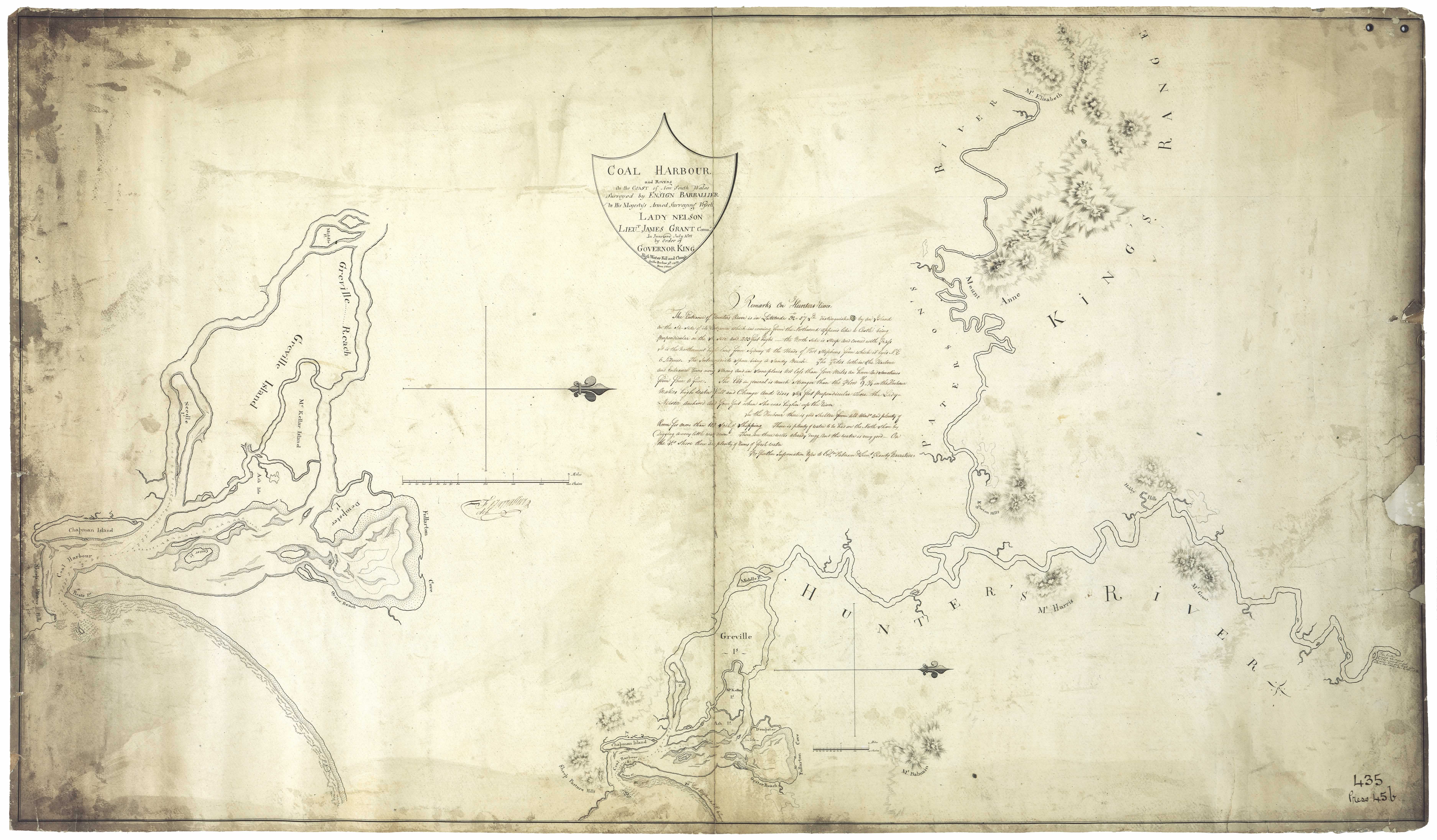
Duck River Farm - Farm belonging to Francis Moran
Dudley - named after a place in Worcestershire, England [46]
Duff's Pass - Co. Hunter, a crossing place over Doyle's Creek from Singleton to the neighbourhood of Dabee.
Duguid's Hill - Co. Northumberland, a hill about 2 miles SW of Lochinvar. [37]
Dulcamah Estate - At Whittingham. First owned by Robert A. Rodd who sold it to Duncan Forbes Mackay
Dulwich - Estate of James Glennie. Situated on Falbrook, Co. Durham
Dumaresq St. Newcastle - Named after Col. Henry Dumaresq who succeeded Sir William Edward Parry as Commissioner of A.A. Company. [3]
Dunbar's Creek - Co. Durham. 188 miles N of Sydney. 12 miles from Muswellbrook. [37]. Named after Samuel Dunbar an early settler in the district [46]
Duncans - a creek in the district of Liverpool Plains. On this stream is the station of J.T. Armytage and Co.
Dunedoo - Cassilis district. Aboriginal meaning - small feet [46]
Dungaleer - district of Liverpool Plains. Emanuel Hungerford's station
Dungee - Situated in district of McLeay on Dungee Creek. Station of Alexander Gammack
Dungog - Clear hills (aboriginal meaning). Tunkok (aboriginal name). Gringai tribe. Situated Co. Durham on the Williams River.
Dungowan - district of Liverpool Plains. Run belonging to Isaac Haig, also Hamiltons station. 16 miles from Tamworth
Dunheved - Vineyard near Paterson in 1865 owned by Mr. Steers
Duninald - Estate belonging to William Dun - Paterson River
Duns Creek - near Duninald
Dunmore - Named by Andrew Lang, the original grantee in 1822, after his mothers maiden name - Paterson
Dunmore House - Situated on the estate of Dunmore
Dunolly - Singleton district
Dunvegan Estate - Upper Paterson. Named for a place in the Isle of Skye, Scotland [46]
Dural - district of Liverpool Plains. Station of John Wild
Durham - County of NSW. Towns include Paterson, Muswellbrook, Seaham, Clarencetown, Dungog, Hinton, Gresford, Merton and Camberwell.
Duri - Estate at Broke
Durren Durren - Wyong district - Aboriginal meaning - dry ground out of flood reach [46]
Dusodie - Dungog district [46]
Dyrring - Parish in the Co. of Durham bounded on the W. by Brought; E. by Mirannie; and S. by Sedgefield. In this parish is situated Mount Dyrring, a peak of the Mount Royal Range under which is Falbrook
E
Eaglet - Wollombi district [46]
Eagleton - Estate of Colonel William Snodgrass - situated Co. Gloucester on the Williams River. 9 miles from Raymond Terrace
Early's Cottages - Devonshire Street Maitland. Henry Early
Eastville - East of East Maitland - an extension of East Maitland
Ebeneza - Estate/ coal mine of Rev. Threlkeld at Toronto. Modern day Coal Point.
Eccleston - After a place near Chester, England. Located on the Allyn River. Parish of Avenal.
Edden Park - Early name for Pulbah Island named in 1919 in honour of Minister for Mines.
Edenville - early name for Kearsley
Edith Breaker - Co. Gloucester. Rocky islet, awash, lying directly on the line of coasters' track when passing between Seal Rocks and the mainland [37]
Edgeworth - Named after Sir T.W. Edgeworth-David. Known as Cocked Hat Creek until 1885. Know as Young Wallsend and renamed in 1960 after Professor Edgeworth David [46]
Edinglassie - Estate of George Forbes. Kamilaroi aboriginal name Malgoorieyn
Edmunds Bay - Toronto / Blackalls Park . Named after Edmund Chapman
Eelah Estate - Previously Hunter's Hill - Settler Timothy Nowlan
Egerton Hills - Also Edgerton. At the junction of Hunter and Williams River near Raymond Terrace (see Barrallier's 1801 map) Named for the Duke of Bridgewater.
Eglinton - Robert Crawford's estate at Ellalong, district of Wollombi
Eildon Hall Farm - 1500 acres - 8 miles from Maitland
Elderslie - Named by T.C. Harrington, Assistant Colonial Secretary 1834, after a village in Scotland. Singleton district
Eldon - Parish in Co. Gloucester bound on the N. by Thornton; S by Stockton; E by Stowell and W. by the Williams and Hunter Rivers
Eldon Estate - Estate and residence of Peter Sinclair - Hunter River
Eleebana - Beauty (aboriginal meaning). Lake Macquarie [46]
Elizabeth Island - Port Stephens. Named by Governor Macquarie after his wife Elizabeth
Ellalong - A swampy place (aboriginal meaning). Robert Crawford's land grant. Co. Northumberland. Cessnock district. Named by Sir Thomas Mitchell Nov. 1831 [46]
Ellalong Creek - a small eastern tributary of the Wollombi Brook
Ellalong Lagoon - situated Co. Northumberland near the source of the Wollombi brook. A small swampy lake into which the Quarrybylong Creek drains. [37]
Elland - Denman district. Named after a place in York, England
Ellen Vale Estate - Estate of John Milson, Wollombi
Ellerslie Estate - Estate of Richard King - Jerry's Plains
Ellerston Estate - Estate of H.C. Sempill - Upper Hunter. Named after a place in Gloucestershire, England [46]
Ellis - A parish in Co. Brisbane bounded on the S. by Clanricarde; E by the Hunter River and N. by Strathearne
Ellulang Estate - 13 miles from Maitland.
Elm's Hall Estate - Upper Paterson
Elmswood - estate at Pages River
Elrington - Cessnock district
Emerald Vale - near Gresford 1870
Ena Creek - Co. Gwydir, a western tributary of the Macintyre River flowing through scrubby pastoral country.
Engheim - Estate of Charles Ferdinand Hamilton Smith
Enwylong - N. W. Raymond Terrace [46]
Erangeroo - Co. Parry, a high peak of the Peel Range, lying 5 miles E of the township of Carrol. [37]
Eraring - That which gleams or glitters (aboriginal meaning). Percy Simpson's grant of 7th April 1838 (Coorumbung Parish) covered Eraring. Yererung on Henry Dangar's 1828 map [29]
Erraring Bay - Arcadia Vale (Map - Lake Macquarie: Parish of Awaba, County of Northumberland)
Erina - a creek in Co. Northumberland; flows into Brisbane Water at the town of East Gosford
Erringi - or Erringhi. Aboriginal name for Clarencetown. Place of the black ducks
Esdai - Denman district [46]
Eskdale - Land granted to Walter Scott - Williams River. Situated on the opposite bank to Irrawang
Estelville - Old name for Cameron Park. Named after the Hon. John Estell, Minister for Mines [46]
Estellville - On Map of Young Wallsend
Eulengo - Estate of E. Doyle at Jerry's Plains
Euroka - district of Liverpool Plains; station of E.B. Cornish
Evelien - Area of Cardiff South (c. 1904)
Ewbank - located at Singleton. Bank manager's residence
Eyeball Reach - Estate of William Peppercorn
F
Failford - Co. Gloucester 219 miles N of Sydney. [37]
Fairfield Farm - Near Newcastle 1850s
Fairley - Holmesville
Fairylawn - Residence of J. Enright. Formerly the site of the iron gang stockade at Maitland
Falbrook - a stream of water in Co. Durham. Flows through Camberwell and into the Hunter River. Fed by the Carron and Goorangoola Creeks and the Foybrook. [37]Named after the River Fal in Cornwall, England [46]
Falbrook Estate - 4000 acres belonging to Alexander Brodie Sparke. Hunter Valley
False Bay - early name for Fingal Bay because mariners mistook it for Port Stephens
Fame Point - Port Stephens - named after the vessel Fame
Farley - Co. Northumberland. Named by Captain Emmanuel Hungerford, a settler of 1828, after his home town Farleigh near Bath, England
Farmborough - The original name of Branxton was Farmborough. Later it was known as Black Creek. Farmborough was part of William Bowen's estate
Fassifern - Suburb of Lake Macquarie. Co. Northumberland. Named after place in Loch Eil, Scotland [46]
Fennells Bay - named after Richard Fennell who settled in the district in 1847 [46]
Fenninghams Island and Mud Point - Located at the mouth of Tilligerry Creek, Port Stephens. Approx 1100 acres
Fenwick's Hill - near Gresford
Fermoy Cottage - Devonshire St. West. Maitland. Jeremiah Ledsam
Fernance - St. Albans district. Named after John and Charles Fernance, pioneers of the district
Fern Gully - Singleton district
Fern Hill - Singleton district
Ferodale - Raymond Terrace district [46]
Figtree Point - Point of land on the southern side of Fennell Bay bridge
Finch Mount - Co. Northumberland. A peak in the Hunter range about 6 miles SE of Wollombi. [37]
Fingal Bay - A bay situated in the county of Gloucester, near Port Stephens harbour. Early name False Bay
Firefly Creek - Co. Gloucester. A tributary of the head of the Burril Creek. [37]
Fishery Creek - located between Hexham and Sandgate - drained into Hexham Wetlands
Fitzroy - a parish in Co. of Gloucester bounded on the N. by Crosbie; S by Verulam, and E. by the Australian Agricultural Company's estate
Five Islands - Boolaroo; Teralba district
Flaggy Creek - located at Glenrock Lagoon
Flaggy Creek Reserve - East of Kahibah. Approx 300 acres
Flagstaff Hill - Newcastle (aboriginal name Tahlbihn Point). Early name for Fort Scratchley
Flowerbank Hill - Singleton
Fly Road - Co. Gloucester. Beteen Stephens Point and Toomeree Heads. [37]
Foley's Folly - Co. Parry. Quartz mining village situated 3 miles from Hanging Rock township. [37]
Forbestown - private subdivision at South Muswellbrook.
Fordwich - Wollombi Brook - Arthur Blaxland. Singleton district
Fordwick - Situated at Gammon Plains, Co. Brisbane
Forster - After William Forster, Premier of NSW 1859. Co. Gloucester. 227 miles N of Sydney. Called by the Manning River aboriginal Wooboomba meaning That Kangaroo
Fort Fiddlesticks - Convict name for Fort Scratchley
Fort Scratchley - former fortifications perched atop a large knoll that lies immediately behind, and overlooking, Nobbys Beach, the headland and the river mouth. Named for architect Col. Peter Scratchley Named Braithwaite's Head by Lieut. Shortland in 1797
Fosterton - small settlement near Chichester River. 10 miles N of Dungog
Four Mile Creek - Earlier name Bagman Creek. Tributary of the Hunter River flowing through Millers Forest
Foybrook - A stream of water in Co. Durham. Empties into the Hunter River near Camberwell
Frederick Point - Co. Northumberland - a tongue of land jutting out into Brisbane Water Harbour and forming part of the township of Gosford. [37]
Freeman's Waterhole - a settlement south of The Gap once known as Heatonville
Frenchmans Rock - Swansea - Named for the French ship Henri which foundered in 1852
Freshwater Bay - Shown on Barrallier's 1801 map of Newcastle Near Stockton [31]
Freshwater Creek - Teralba; also known as the Gravel Pits.
Friendship Point - early name for Soldiers Point, Port Stephens
Frog Hollow - Dudley.
Frying Pan Point - Lake Macquarie. South of Point Wolstoncroft
Fullerton Cove - After William Fullerton traveller and soldier 1754- 1808.[46] Situated Co. Gloucester. Extensive Cove of Port Hunter. A large lagoon on the N shore of the Hunter River opposite Newcastle. A large sandy island called Wallis' Island lies on its western side and a small sandbank at its entrance. [37]
Furrucabad Creek - Co. Gough - a small tributary of the Rocky Ponds Creek flowing near the township of Glen Innes
G
Galathra - Run belonging to W.C. Wentworth at Liverpool Plains
Galgabba - Aboriginal name meaning a place far away, for an area at Pelican's Flat, near Swansea [46]. Residence of Thomas Boyd in 1880
Gallagher's Mountain - near Turanville
Gammon's Plains - Co. of Brisbane 150 miles from Sydney. Near the township of Merriwa. [37]
Gangan - Stockton district. Aboriginal meaning - the top of surface of the sandhills or of a precipice [46]
Gangat - Gloucester district - Aboriginal meaning - a fish hawk [46]
Gaol Hill - Newcastle. Site of the Old Gaol. Situated at the beach end of Scott Street Later a tram depot.
Garden Suburb - Gordon Avenue area of Hamilton
Garden Suburb - North of Stockton. Also known as Corroba
Garawantara - any plain, a flat
Garewagal (Geawegal)- native land/people on sea coast and Hunter River
Garland Valley - Singleton district
Garrangola - (Goorangoola) a creek in Co. Durham. Branch of Fallbrook
Garside Gardens - King Edward Park. Named after Bob Garside who was superintendent of parks and gardens at Newcastle
Gaspard - Quirindi district [46]
Gateshead - named after a suburb of Newcastle-on-Tyne, England [46]
Gearywah - Manning River aboriginal meaning the iguana. Black Head the seaside resort
Geawegal - native language Hunter River
Gee's Crossing - near Ravensworth
Genena Hill - early name for Violet Hill at Myall Lakes
George The Barber's Stockyard - Grazing run on the Namoi belonging to Sir John Jamison
Georgetown - Originally called Geordie Town. Suburb of Newcastle named after George Moate who acquired land in the area in 1853. Adjacent to Hanbury (Waratah)
Geraldine Cottage - Singleton - Built in 1847 and once served as the Anglican school and parsonage
Giant Creek- a creek in Co. Brisbane; it flows into the river Goulburn
Giant's Leap - high country above Giant Creek - Dangar's Map [29]
Gibbagunyah Creek (aboriginal meaning house built of stone, shallow cave). West of Scone [24]
Gibbers, The - A headland on the coast opposite Broughton Island
Gilcoobil - (Kickerbill)- station of A and J. Blaxland in district of Liverpool Plains
Gilgandra - Kamilaroi aboriginal name Geelganderra meaning youth who had gone through the third bora ceremony
Gillieston - After John Gillies, Mayor of West Maitland 1888
Gineroi - district of Liverpool Plains on the Gwyder river. 280 miles from Maitland; Galley's station
Gingamboon (Kingimbon) Hunter River [24]
Ginger - Run at Liverpool Plains taken up by Nelson Simmons Lawson
Ghingi - mountains
Giant Creek - Flows into Sandy Hollow
Gircobill - situated in district of Liverpool Plains, 22 miles from Gammon Plains
Giro - Gloucester district. Aboriginal meaning a black satin bird [46]
Girriwillie (Garrawilla) - Namoi River. Squattage of Charles Purcell, son of John Purcell, one time Commandant at Newcastle
Girvan - Booral district - named after a place in Ayr, Scotland [46]
Glandville - another name for Ash Island
Glebe Farm - Newcastle, Peter Flemming
Glebe Cottage - West Maitland 1844 Glebeland - Co. Northumberland, a village 2 miles from Adamstown [37]
Glenalbion Estate - Situated on the Paterson River
Glenalvon - Murrurundi. Estate of Peter Brodie 1840s. Later acquired by the White family
Glenarm Estate - Williams River four miles from Seaham. Estate of Mr. Clode 1857
Glencairn - Upper Hunter Valley. Also known as Cressfield, the estate of Archibald Little
Glendon - Co. Durham on Glendon Brook near Singleton. Named by Robert and Helenus Scott after their home in Scotland
Glendon Brook - Co. Durham. The Brook is a fine stream rising in the Mount Royal Ranges flowing into the Hunter River between Maitland and Singelton [37]
Glendor - Farm of John Thomas on the swamps near Wallsend
Glendon Farm - Farm of W.B. Fenwick near Newcastle in 1840s
Glenhunt - Estate adjoining Ravensworth owned by Bourn Russell
Glenlivit Estate - Williams River. 1500 acres. One mile from Clarencetown
Glen Martin - Clarence Town district [46]
Glenoak - Clarence Town district [46]
Glen Mitchell - name given to Quigley Estate, Lake Macquarie
Glen Musa - farm at Big Redhead owned by Mr. Bailey in 1870s
Glennies Creek - After James Glennie, early settler
Glenridding - situated in Co. Durham on Hunter river near Maitland. Grant to John Earl
Glenrock - property belonging to Alexander Campbell at Barrington Tops
Glenrock Lagoon - south of Newcastle. Also known as Valley of the Palms. Later Burwood. Nearby as Wahrah on Dangar's 1828 map
Glenrose - Farm of Rev. George Augustus Middleton - Paterson
Glenthorne - Estate of Rev. Alfred Glennie three miles from Charles Boydell's Camyrallyn, Paterson district. In 1865 3 acres under vine owned by Gilbert Champain
Glenview Farm - 4 miles from Raymond Terrace
Glen William - Co. Durham - postal village on the Williams River 5 miles from Clarencetown. [37] Named for William, Duke of Clarence, who later became King William IV [46]
Gloucester - After the Cathedral city in England - River and County in NSW
Glupton - Co. Brisbane, township 232 miles N. of Sydney. [37]
Gnoolooma - run belonging to Joseph Pearse at Liverpool Plains
Goat Hill - Pittown area of Wallsend
Goat Island - (native name Memel) an island situated at the mouth of the Parramatta River in the harbor of Port Jackson
Goat Island - small island in the Hunter now part of Kooragang
Goat Island - in Lake Macquarie
Gola - Kamilaroi aboriginal name for Overton estate [39]
Goloyauwe - a point of land on the south side of the Lake
Goo-a-rinda - Grazing run of George Thomas and Andrew Loder at Quirindi Creek
Goodar - Run at Liverpool Plains taken up by James Marks
Goomawidyera - Kamilaroi name for Dart Brook [39]
Goonal - district of Liverpool Plains on Waterloo creek; Thomas Brown's station
Goonda Point - at Wangi - Aboriginal word meaning fire or star (Israel's subdivision map c. 1923)
Goonoo-goonoo - Co. Parry. 360,000 acres selected and settled in 1834 on a river later known as the Peel. The settlement became the foundation of the city of Tamworth. District of Liverpool Plains on the Goonoo-Goonoo Creek near the Peel River being a gold mining district on that river. [37]
Goonoo Goonoo Creek - a southern tributary of the Peel River rising near the township of Goonoo-Goonoo and flowing into the Peel at Tamworth. [37]
Goonou - a river in district of Liverpool Plains. Branch of the Peel river
Goora - On the peel river in the district of Liverpool Plains
Goorable - in the district of Liverpool Plains on the Gwyder River 300 miles from Maitland. Station of Andrew Blake.
Goorangoola - (also Garrangola). Co. Durham. A bend in the creek. (aboriginal meaning). Estate owned by Robert Dawson
Goorangoola Creek - a small tributary of the Falbrook fed by the Campbell's Creek. [37]
Gorian - Run belonging to Joseph Pearse at Liverpool Plains
Gorriagilla - run at Liverpool Plains taken up by John McDonald
Gorroinba - the female emu place
Gosford - Co. Northumberland. Situated on an inlet of the sea from Broken Bay calld the Broadwater. Tuggerah Lake lied 9 miles north. [37]
Gosforth - Parish in Co. Northumberland bounded on the N. by Hunter River; W by Branxton and Allandale; S by Heddon and E. by Maitland
Gostwyck - Estate of Edward Cory at Paterson River.
Goulburn Grove - Estate of Standish Lawrence Harris. Situated Co. Durham at the junction of the Hunter and Paterson Rivers. Known as Trafalgar in 1848
Goulburn River - discovered by Lawson and Scott in 1822 in their endeavour to reach the Liverpool Plains. They named the river after Major Goulburn, the Colonial Secretary.
Gouldsville - Singelton district. Named after the pioneer family of Gould, timber millers [46]
Government Garden - Pacific St. Newcastle near intersection of Reid lane area overlooking the Newcastle surf club pavilion.
Gowrie - Singleton district
Grassy Haugh Estate - Henry Fisher, Black Creek
Grass Tree - Co. Durham. Muswellbrook district. 173 miles from Sydney. Descriptive of the large size and numbers of grass trees [46]
Gravel Pits - Teralba; Freshwater Creek
Gravesend - Cattle Station near Warialda, Gwydir District (1888)
Great Lodge - Estate of Richard Hobden - Hunter River
Green Hill - name given to by Lieut. Shortland to Raymond Terrace
Green Hill Farm - Farm belonging to David Davis at Wollombi
Green Hills - Estate of Edward Close. Later known as Morpeth.
Greenaway's Creek - near Raymond Terrace
Greenlands - Singleton district - named by the Postmisstress Miss Jane Kermode about 1910 in contrast to Greylands, a place close by [46]
Greenland Farm - Estate of Greenway family 1828
Green Wattle Estate - 1280 acres 4 miles from Hinton 1843.
Greenwood Estate - Situated near Singleton on the South West side of the Maitland to Singleton Road. Estate of G.H. Green
Greigs Creek - Named for Robert or his cousin James Greig - A creek situated in the county of Hunter also known as Burreen Creek. Flows into the Hunter River.
Gresford - Co. Durham. After a town on River Allyn, near Chester England. Situated on the Paterson river 1 1/2 miles from the Allyn River. [37]
Greta - village situated in Co. Northumberland on Black creek between Maitland and Singleton. 11 miles W. of Maitland
Gretamain - Cessnock - so named because the coal mine worked the main Greta seam [46]
Greville Island - Island in the Hunter River named after Charles Francis Greville by Ensign Barrallier. Also known as Ash Island. [31]
Grey's Creek. Co. Hunter. A southern tributary of the River Hunter. [37]
Grossman House - located at Maitland - one of two mirror image, Victorian Regency properties, built side by side on the same lot in 1870-71 for the prosperous business partners, Isaac Beckett and Samuel Owen.
Grove Cottage - Allyn River. Residence of Hopson and Miles
Grovetown - early name for Waratah Guangua Creek - Co. Brisbane, an eastern tributary of Wybong Creek.
Gully Line - name given to a railway line owned by Caledonian Collieries. Ran from Charlestown gully and crossed Lambton Rd at Broadmeadow. Original name Raspberry Gully
Gulong Mount - Co. Northumberland - a high peak in the Hunter Range in the parish of Blaxland and to the SW of Wollombi township. [37]
Guluthrea - district of Liverpool Plains 138 miles from Murrurundi. Squattage of W.C. Wentworth
Gummum - a creek situated in Co. Brisbane. Empties into the Goulburn river.
Gummum Plains - Merriwa district. Watered by Merriwa creek
Gum Tree Hole - Singleton district
Gunady - District of Liverpool Plains on the Mooki river 68 miles from Murrurundi; J. Johnston's station
Gunadaddy - district of Liverpool Plains on Gunnunderry creek at Mallalay Plains. Station of A. Denison
Gunandelly - district of Liverpool Plains on the river Mooki. Allen's station
Gundalia - 2 miles from Terrabi on the Barwan River [40]
Guangua Creek - Co. Brisbane. Flows into Wybong Creek
Gundamine - district of Liverpool Plains on the Namoi River 130 miles from Murrurundi. Station of Campbell and Ryan.
Gunderman - a creek situated in Co. Northumberland; flows into the Hawkesbury river.
Gundibri - on Gungal or Hall's Creek near Merton. A grant to Rev. John Dunmore Lang. Later owned by George Hall
Gundy - (Gunda) A camp (aboriginal meaning). Situated Co. Brisbane on the Page's River
Gundy Gundy - A parish in Co. Brisbane bounded on the S. by Macqueen; E. by Pages River
Gunerai - Run belonging to George Gally then James King at Liverpool Plains
Gungal - situated in Hall's creek in the county of Brisbane. Aboriginal meaning Bullrushes
Gungalla. As above. Aboriginal meaning rushes.
Gunnedah - (aboriginal - Goono dha) meaning a poor or destitute man. Namoi River. Alternative meaning Many white stones.
Gunygudah - a creek in district of Liverpool Plains. On this stream is the station of George Bowman situated 100 miles from Murrurundi.
Gurby - District of Liverpool Plains at Waterloo Plains 165 miles from Murrurundi. Station of the Bank of Australasia
Gurranba - a place of brambles
Guygallon Estate - Owned by James Webber - Paterson River
Gwandalan - Lake Macquarie; (aboriginal meaning haven of rest, quiet and peaceful waters)
Gwydir (or Kindur); a river in the district of Liverpool Plains. (aboriginal Gu-i-da meaning place of red (banks)
Gwydir - district of Liverpool Plains on the Gwydir river 30 miles from Armidale. James Hale's station
Gyarran - Kamilaroi aboriginal for Muscle Creek [39]
H
Hacking Point/ Island - Early name for Nobbys. Named by Lieutenant Shortland in 1797 after Quartermaster Hacking of H.M.S. Sirius
Hall's Creek - Co. Brisbane; flows into the Goulburn river
Hall's Hill - steep hill near the junction of the Dungog and Gloucester roads named after Charles Hall superintendent of Australian Agricultural Co.
Halliday's Point - Co. Gloucester, a sandy beach lying about half way betwen Cape Hawke on the S and Farquhar inlet on the N. [37]
Hallsborough - Maitland - House of William Hall a Waterloo veteran of Maitland
Halton - Co. Durham 160 miles N of Sydney. [37] Named after a place in Sussex, England [46]
Halton Estate - Allyn River
Hambledon Hill - Singleton district. Various owners - Henry Nowland, Mr. Dines, Augustus Hooke, Mr. Dunster.
Hamilton - Suburb of Newcastle. Named after the residence of William M. Carlyle Secretary of the A.A. Company which was named after Edward Hamilton, Governor of the A.A. Company 1856 - 98. Previously known as Pittown and The Borehole.
Hampton Estate - Left bank of Cockle Creek. Argenton, Lake Macquarie
Hampton Park - Jerry's Plains. Estate belonging to Peter Duff in 1838
Hams Beach - Caves Beach - named after William Henry Ham, first resident
Hanbury - early name for Waratah. Named by Thomas Grove after his birthplace in Staffordshire England.
Hanging Rock - Gold fields near Nundle. Land originally taken up by Nathan Burrows in 1848. Co. Parry, situated on the Oakenville Creek, the rivers Peel Barnet, and Manning taking their rise in the surrounding mountains. [37]
Hanging Rock Creek - Co. Parry - a small auriferous eastern tirbutary of the upper end of the Peel River rising in the western slope of the Australian Alps and flowing into the main stream between Nundle and Dungowany. [37]
Hanging Rock - Co. Northumberland - a remarkable block of red sandstone on the bank of the Wollombi Brook No. of Mount Colabeen. [37]
Hanley's Creek - North of Dungog
Hannan Street Maitland - Named after John Hannan
Hannan House Maitland
Happy Flat - Hamilton from Steel Street to Turner Street
Happy Valley - Co. Parry - an auriferous gully lying between Wallabadah and Hanging Rock
Harben Vale - in the Co. of Brisbane on Page's river 4 1/2 miles from Murrurundi. Estate of William Henry Warland
Hardwick Range - Liverpool Plains
Hardys Hill - Name given to the hill at Speers Point which was the site of an old council quarry
Harrowby Estate - Wollombi Brook. A grant to John Tremayne Rodd (see Dangar's Map)
Hartfell - formerly known as the Gunnedah run owned by Johnston at Gunnedah
Harthill Farm - property of Rev. J.H. Garven near Maitland
Hartley Coal Mine - Lake Macquarie 1870
Hatfield Park - farm 4 miles from Dungog
Hat Hill - Co. Northumberland. [37]
Hathorn's River - flows into Carrington River (See Dangar's map)
Hawke Cape - Co. Gloucester - a rocky promontory 16 miles to the N. of Sugarloaf Point. [37]
Hawke Cape - Settlement. Co. Gloucester - lies on the Maclan and Wollombi Rivers on Lake Wallis. [37]
Hawkes Nest - Co. Durham - 148 miles N Sydney. [37]
Haydonton - a private town situated in Co. Brisbane across the Page River from the town of Murrurundi. See Thomas Haydon
Heatherbrae - Suburb of Port Stephens near Raymond Terrace
Heaton - Cessnock district
Heaton's Gap - also known as Brunkerville Gap or The Gap - a pass over the Watagan Mountains
Heatonville - a timber getting settlement south of The Gap now known as Freeman's Waterholes
Hebburn - After a suburb of Newcastle-on-Tyne
Hebden - Singleton district. Named after a place in Yorkshire England [46]
Hecknadiiey - Aboriginal name for the pass over the Liverpool Ranges
Heddon - a parish in Co. Northumberland bounded on the N. by Gosforth; S. by Stanford; E. by Maitland and Strockrington and W. by Allandale.
Heddon Greta - village established near a coal mine Heddon is named after a place to the west of Newcastle-on-Tyne. Greta is named after the seam of coal discovered by Professor David [46]
Hernani - Wollombi district. Named after places in Spain [46]
Hexham - Newcastle suburb. Grant to Edward Sparke in 1820';s. Situated Co. Northumberland half way between Newcastle and Maitland. Named after market town of Hexham, England
Hexham Swamp (Aboriginal name Burraghihnbihng) - Territory of the Pambalong or Big Swamp Tribe. - A large tract of marshy land between Hexham and Minmi - [37]
Hide's Creek - Co. Parry - a small auriferous tributary of the Peel River joining it at Bowling Alley Point diggings. [37]
Highfields - Newcastle suburb. First subdivided by John Isaac Cotterill in 1920 (Lake Macquarie History)
Highgate - Barnsley - early subdivision c. 1880
High Street, Newcastle - Lieut. Charles Jeffreys of the brig Kangaroo produced a survey map in 1816 naming the one street in the Coal River settlement as High St. This later became Watt St.
Higham Road - Co. Northumberland. A township 4 miles from Waratah. [37] Named after a place in Kent England [46]
Hilldale - Paterson district, descriptive [46]
Hillrock - estate 8 miles up the Rouchel Brook
Hillsborough - Estate of Beresford Hudson - Hunter River near Maitland. Named after a place near Belfast, Ireland [46]
Hillsborough - Named after an early landholder of Lambton Dr. John James Hill. Situated at Lake Macquarie
Hillsend Farm - Also known as Greig's Farm. Upper Hunter
Hillside - property north of Dungog
Hinnes Craigs - Gloucester
Hinton - Co. Durham, parish of Hinton at the junction of Paterson and Hunter Rivers and to the S of the Mount Royal ranges. [37]
Hinton Estate - Adjoining the Bowthorne Estate. A grant of 640 acres to Robert Coram Dillon. Named after Dillon's ancestral home in England
Hobart Place - residence of F. J. Shaw, Mayor of Newcastle 1876
Hobby Hill - situated near Hunter River downriver from Maitland - mentioned on Barrallier's 1801 map in HR NSW p. 420
Hoddle - Mountain situated in the district of Liverpool Plains between the Rivers Peel and Turrabeile
Hogg Island - (Former) Island in the Paterson River
Holdsworthy Downs - Situated just above the confluence of the Dartbrook with Kingdon Ponds in Co. Brisbane (See Dangar's map). About a mile to the W. of Scone
Holkham/ Holkam - In the county of Brisbane on the Hunter River 5 miles from Scone. Estate of Henry Dangar
Hollydene - Denman district [46]
Hollow Tree Farm - Bounded on the land belonging to Siddons and Peppercorn 1841. Charles Croaker. See Hunter Valley Settler Map1. Subdivison in 1892 adjoined Raymond Terrace Racecourse
Holmesville - West Wallsend district. Named after a resident, a miner Joseph Holmes [46]
Holmwood - Private residence of the Rusden family in West Maitland
Homebush - Estate of John Field
Honeysuckle Point - name given to area adjacent to Newcastle Harbour because of native plant resembling honeysuckle flower [3]
Hookanvil Creek - Vicinity of Hanging Rock. Also known as Ogunbil Creek, Oakey Creek, Oakenville Creek and Hanging Rock Creek.
Hope Cottage - near the Long Bridge Maitland
Hopewell Cottage - Cottage on the Bowthorne Estate
Horning Creek - Co. Northumberland - a small tributary of the estuary of the Mangrove Creek. [37]
Horseshoe Beach - beach at Newcastle
Horton - Parish in Co. Gloucester bounded on the North by Thalaba; S. by Wilmot; E. by Karuah and W. by the Williams River.
Horton Park - Muswellbrook district
Howe's Valley - After John Howe, who, with Benjamin Singleton discovered Patrick Plains on 17 March 1820.
Howick - a parish in Co. Durham bounded on the W. by Wynn; S. by the Hunter River and E. by Ravensworth.
Humumba - Run belonging to Edward and George Rouse at Liverpool Plains
Hungry Flat - Co. Northumberland. A flat on the Great North Road from Sydney to Maitland at Mangrove Creek. See Dixon's map
Hungry Hill - Paterson
Hunniford lane, Newcastle - Named after a contractor of that name. [3]
Hunter's Hill - Estate of Timothy Nowlan. Later known as Eelah
Hunter National Park - Plateau south of Hunter and Goulburn Rivers to the northern watershed of the Hawkesbury River
Hunter Range - a branch of the Blue Mountain Range separating the tributaries of the Hawkesbury from those of the Hunter.
Hunter Street - and Hunter Street West originally consisted of Hunter Street to Brown Street, Blane Street from Brown Street to Cottage Creek, thence Charlton Street to the western boundary of the city. All that portion of the thoroughfare known as Hunter street West was named by the A.A. Co , Blane street (from the Bank of Australasia to the old Cottage Creek) after Mr. Blane who as deputy-governor in 1850, sailed for Port Stephens to facilitate the sale of land and settlement of the estate there. From Cottage Creek to the western boundary of Newcastle, the continuation of Blane street, was known as Charlton street. Mr. Charlton was one of the overmen at the pits and with Mr. Steele took charge of the colliery working after the going of the manager Mr. Plews, who succeeded Mr. Brown. [3]
Hunter's River - Named after Governor John Hunter by Lieut. John Shortland. For many years known as the Coal River. (Aboriginal name Coquun; Myan or Coonanbarra) Also Gingamboon.
Hunter Street, Newcastle - previously known as Blane Street.[3]
Huthfield - Mulberry Creek
I
Illalong / Illalung - Early name for Morpeth. Named by E.C. Close after the aboriginal name meaning swampy plains
Illalong Swamp - Co. Northumberland - a swamp lying to the E of Morpeth. [37]
Ingar - Street in Gwandalan, Lake Macquarie (Aboriginal meaning - Place of rest)
Ingar - or Inga. Singleton district. Aboriginal meaning - a place of rest [46]
Ingliston - Co. Northumberland - a township 120 N of Sydney. [37]
Invergordon - Gloucester district - named after a place in Ross and Cromarty, Scotland [46]
Invermein - Estate of Francis Little Situated Co. Brisbane on Dartbrook Invermere - Co. Roxburgh at Holdsworthy Downs -Dangar's Map [29] Named on 15 July 1823 by Francis and Archibald Little who came from Dumfries, Scotland. Gaelic word meaning the meeting of the waters [46]
Iona Estate - Paterson. Named after an island on the west coast of Scotland [46]
Irish Town - Early name for the area around Mill Brook estate
Iron Bark Creek - (aboriginal name Toohrnbing) - near Newcastle on Dangar's 1828 map. Small southern tributary of the Hunter River falling into it below Hexham. [37] Named because of the number of ironbark trees [46]
Iron Bark Creek - Name given by Lieut. John Laurio Platt to his estate
Iron Bark Farm - near Newcastle
Ironbark Creek - Run belonging to Messrs Spencer at Liverpool Plains
Iron Stone Knob - Yarramalong. In 1913 Robert Woolley could point out a stringy bark tree on or near a hillock locally known as the Iron stone Knob, with Sir Thomas Livingstone Mitchells inscription still thereon.
Irrawang - Estate of James King. Aboriginal meaning where the water runs
Irrawang Cottage - Raymond Terrace. School in 1855
Isis River - Co. Brisbane - Stream rising in the Liverpool Range near Downey's Pass and flowing into the Page River near Gundy Gundy. [37] Named after the name of the upper waters of the River Thames, England [46]
Islington - Suburb of Newcastle. Named after a suburb of London [46]
J
Jackass Falls - Seaham
Jack's Creek - Liverpool Plains
Jacob and Joseph - station of John Eales situated at Liverpool Plains
Jarvistone - near Nelson's Plains - Dangar's map [29]
Jenny's Creek - Co. Parry - a small auriferous tributary of the Peel River joining it at Bowling Alley Point Diggings. [37]
Jerry's Plains - Co. of Hunter on the South bank of the Hunter River. Old name Cumnaroy. The plain is surrounded by high ridges known as the Bulga Mountains.[37]
Jervis Farm - Farm belonging to Alexander Warren, Williams River
Jesmond - Suburb of Newcastle. Named after a suburb of Newcastle-on-Tyne, England [46]
Jewells (near Belmont) Should be Jules, as it was named after Jules Windeyer an old resident of Newcastle who used to go shooting there, or, named after Alec Jewell, the licencee of the Belmont Hotel 1923-25 [46]
Jewhurst's Farm - 900 acres originally granted to George Townshend, Paterson
Jew's Lagoon - on Namoi River
Jigadee Creek - early name for Sandy Creek a branch of Dora Creek
Jilliby - Wyong district - Aboriginal meaning - a valley or where two creeks meet [46]
Jilliby-Jilliby Creek - Co. Northumberland - a tributary of the Wyong Creek fed by the Nellering Creek.
Johnson's Hill - Paterson
Johnys Point - near Silverwater, Lake Macquarie.
Jonestown - Cardiff. Part of John Jones 1862 land grant
Jooloogan Estate - at Dartbrook
Judge Dowling - a range of mountains situated in the Co. of Northumberland, a part of the Carmarthen Mountains. Formerly named the Devil's Backbone. 65 miles from Sydney. From this spot may be seen ' Yengo,' a remarkable flat-topped mountain to N.W., Well's Gazeteer
Jump-up - Later known as Belford
Jump-up Creek - Patrick Plains. A small souther tributary of the Hunter River flowing through the township of Belford
Jump-up Hill - Mount Royal Ranges
Juri - Co. of Parry. A township on the northern railway to the S of Tamworth. [37]
K
Kahibah - Quick, active, eager (aboriginal meaning) [46]. See Dangar's map [29]
Kaiaraba - place of sea weeds
Kalburn Estate - Near Trevallyn on the Paterson River
Kalingo or Kaligo- near Ellalong (aboriginal meaning by the water)
Kalingo Colliery - established 1939 near Cessnock
Kallitoota - Denman district. Aboriginal meaning Evergreen [46]
Kalongba - Wollombi district - Aboriginal meaning - a faraway place [46]
Kalsina Flat - Mayfield East was originally known as Kalsina Flat because the original inhabitants worked at the Calcina Furnaces at the Port Waratah copper smelting works.
Kaluda - 560 acres part of the original Lochinvar estate granted to Leslie Duguid purchased by J.F. Doyle. John Doyle established a vineyard which was managed by P. Terrior. By 1933 the farm was a dairy and owned by the Gurr family
Kamilaroi tribe - from headwaters of the Hunter from the Talbragar to the Nunmurra waters
Kangaroo Hills - Lease of Henry Dangar in the New England
Kangra Creek - Co. Northumberland - a small tributary of the Mangrove Creek. [37]
Kangy Angy - a mountain situated in Co. Northumberland near Wyong Creek
Kankool - Murrurundi district. Aboriginal meaning - a wallaroo [46]
Kanwal - also Kauwal. Aboriginal meaning great, large - referring to the Tuggerah Lake [46]
Karakunba - a place of swamp oaks
Kareen - a river situated in district of Liverpool Plains; flows into the Gwyder
Karrabee - Denman district. Aboriginal meaning - a cockatoo [46]
Karraganbar - Wyong district - Aboriginal meaning - a place of swamp oak trees [46]
Karraganbal Point - Co. Northumberland. Tuggerah Beach Lakes. [37]
Karrak - Manning River aboriginal meaning Spittle
Kars Springs - Scone district
Karuah - A native plum tree (aboriginal meaning). Parish situated in Co. Gloucester bounded on the N. by A.A. Co Estate; on the S. by Tarean; E. by the Karuah river; and W. by Horton
Kawanggawa Brook - Flows into the Hunter River -Dangar's Map [29]
Kayuga - A plain (aboriginal meaning) [46]. Estate of Donald McIntyre - Upper Hunter. Kamilaroi aboriginal name Talgoobewaa
Kearsley - After William Kearsley the first member of Parliament for Cessnock
Keel-keelba - a place of grass tree
Keepit - district of Liverpool Plains on the Namoi river. William Sims Bell's station
Keepit - Co. of Parry, postal village 313 miles N. of Sydney. [37]
Keera - district of Liverpool Plains on Bundara Creek; A. McPherson's station
Keightly st. Newcastle - named after Stewart Keightly, Mayor of Newcastle [3]
Keinbah - Maitland district. Aboriginal meaning - Place of termites [46]
Kellabakh - Manning River aboriginal name for the Blue Gum Tree
Kelso Estate - Near Singleton. Alexander Munro established the Bebeah Vineyard on the estate
Kelso Place - Singleton
Kelvinside - estate near Aberdeen
Kemp St. Newcastle - named after Simon Kemp, Mayor of Newcastle [3]
Kendall Grange - Morisset Park
Kennington - Estate of William Peppercorn and then William Bowden. Near Tomago on the opposite bank to the Hexham Hotel ( 1878). Named after a suburb of London [46]
Kenrick Cottage - Lake Macquarie Road, Newcastle 1862
Kenrick St. Newcastle - named after Atwell Kenrick, wharf manager and coal salesman who succeeded William Croasdill [3]
Kerowahlahrn - Dangar's 1828 map - area between Lake Macquarie and Catherine Hill Bay
Keerrabee - Co. Durham. Postal village 35 miles from Muswellbrook. [37]
Khangat Mount - Co. of Gloucester. A lofty peak lying on the S. bank of the Manning River 16 miles W of Wingham. [37]
Khanterin - Aboriginal name for Shepherd's Hill, Newcastle
Khappingal Creek - Co. of Gloucester. A small southern tributary of the Kooraingal Creek. [37]
Kiambir - run at Liverpool Plains taken up by John Miller
Kickerbill (Gilcoobil)- station of A and J. Blaxland in district of Liverpool Plains
Kilaben Bay (Killibinbin)- Lake Macquarie. Aboriginal meaning shining, bright, glorious [46]
Kilbrawny - Butterwick - see Dangar's Map Kilcoy Estate - Raymond Terrace; also known as Timavus; a grant to W. McLean
Killabin - Shining (aboriginal meaning)
Killarney station - The Narrabri, or Nurrabri, better known as Killarney station was first taken up by Mr. Andrew Doyle
Killawarra - Manning River aboriginal meaning for a Scrub
Killingworth - coal mining town south of West Wallsend. Named after a place north of Newcastle-upon-Tyne [46]
Killiton Grove - Dungog district
Kilwinning - Raymond Terrace district - named after a place in Ayreshire, Scotland [46]
Kimbriki - Manning River aboriginal meaning for where a kind of water weed grows. Co. of Gloucester
Kimdibakh - Co. of Gloucester. 211 miles N. of Sydney. [37]
Kimmergham Estate - Michael Henderson - Raymond Terrace
Kincumber - Belonging to an old man (aboriginal meaning) [46]. Situated Co. Northumberland, Brisbane Water
Kindur (native name for Gwydir)
Kingdon Ponds - Scone district. A stream situated in the Co. of Brisbane; rises on the Liverpool range and flows into Dartbrook
Kingdon Ponds - Co. Brisbane - a small agricultural village on the creek of the same name 6 miles N. of Scone. [37]
Kinghome - Also known as Torryburn. Grant to John McIntyre - Allyn River
King Junction - Singleton district
King's Creek. Flows into the Hunter River. Near James Arndell's estate (see Dixon's map)
King's Street, Newcastle - named after Governor Phillip Gidley King [3]
King's Town - Early name for Newcastle after Philip Gidley King
Kinross - first known as Warraburreen. Grant to George Thomas Graham. Later purchased by Archibald Windeyer. Near Raymond Terrace. Named after a place near Perth, Scotland [46]
Kintiirrabin / Kentiirabin - aboriginal name for a small extinct volcano on the sea coast near Red Head north east of Lake Macquarie {Threlkeld}
Kirkdale - early name for Arcadia Vale after Joseph Kirk early settler
Kirkton - Estate of William Kelman. Named after Kirktown, Scotland by John Busby
Kirin Rd - Wangi. Aboriginal meaning Queen - Israel's subdivision map c. 1923)
Kitchener - Cessnock district. Named after Kitchener of Khartoum [46]
Kiwarrie - Manning River aboriginal meaning - A lump on a tree, hollow at the top
Klundul - Manning River aboriginal name for where the Wild Carrot grows. Name for Cundletown.
Knockfinn Estate - (also Noch-fin; Knockfen) 8 miles from Maitland. Adjacent to the village of Lochinvar. Estate belonging to Vicars Jacob
Koikaligba - a place of brambles
Koiyog - the site of any native camp -Threlkeld [21].
Kolen Kolen - Mountain near Donny Brook - Dangar's Map[29]. Mount Elizabeth. Kolen = water (Aboriginal meaning)
Kollemungul (Kamilaroi)- Station on the Liverpool Plains on a lagoon of that name. Kolle means water, and mungul means mosquitoe. [40]
Komilla - Liverpool Plains [40]
Kona-konaba - Aboriginal name of the place where the stone called kona-kona is found. Name of a large mountain at the northern extremity of Lake Macquarie -Threlkeld [21]. Known as Murdering Gully.
Kooindah - Port Stephens district. Aboriginal meaning - the sun or day [46]
Koolbury - Muswellbrook district. Aboriginal name for Emu. Koolbury is the name of a closed railway station on the Main North railway line in the Hunter Region. The station opened in 1909 and has been removed, no trace now remains
Koolewong - Gosford district. Aboriginal name a native bear [46]
Koonawarra - Scone district. Duck's high place (Aboriginal meaning) [46]
Kooragang - Estate situated on Mosquitto island, Port Hunter. Estate of Rev. C. Pleydell N. Wilton, Chaplain of Christ Church Newcastle (1848 Well's Gazetteer). Aboriginal meaning Brolga
Kooraingel Creek - Co. of Gloucester - a small stream rising to the S. of Tinonee, flowing into the oceean at Halliday's Point. [37]
Koore Creek - Co. of Northumberland - a small tributary of the Mangrove Creek. [37]
Kooroora Bay - Bay on the lake side of the Fennell Bay bridge
Kopurrba - name of the place from which the aborigines obtained the kopurra a yellowish earth -Threlkeld [21]
Korribakle Creek - Co. of Gloucester - a small creek draining Larry's Flat, and flowing into Burril Creek. [37]
Kotara - A club (aboriginal meaning Kotirra - Threlkeld [21]. . Suburb of Newcastle.
Krambakh -Gloucester district. Manning River aboriginal meaning - a kind of gum tree the bark of which is used for torches [46]
Kuloo - Estate of the Bettington family at Merriwa
Kulubal - a creek situated in district of Liverpool Plains running through the A.A. Co's estate
Kummari - Wangi. Aboriginal meaning - north. (Israel's subdivision map c. 1923)
Kumbaddelo - Liverpool Plains [40]
Kundibakh - Manning River aboriginal name for The Apple Tree
Kundabakl Creek - Co. of Gloucester, a small tributary of Burril Creek, draining Larry's Flat. [37]
Kurraka - Awabakal for the entrance to Glenrock Lagoon
Kurrahboolya -Meaning fork, two gullies, two streams etc., aboriginal name for the junction of the Crawford and Myall Rivers. Bulahdelah.
Kurra-kurran - the name of a place in which there is almost a forest of petrifications of wood of various sizes. It is in a bay at the north western extremity of Lake Macquarie {Threlkled [21]}
Kurrundarra - homestead of Archibald Bell later known as Corinda. Situated across the Hunter River from Glendon - Dangar's Map[29]
Kurranulla Creek - Flows into Carrow Brook. Mt. Royal Ranges.
Kurri Kurri - The beginning, the very first (aboriginal meaning) [46]
Kuttai - the site of Sydney Light house or any peninsula
Kyle - Co. of Gloucester. A postal village 261 miles N of Sydney. [37]
Kyuga - also Kayuga. Muswellbrook district - aboriginal meaning - a plain [46]
L
L'Abri - House built by surgeon George Brooks in 1838, situated at 55 Newcomen-street, Newcastle
Laguna - Situated in Co. Northumberland on Sugar Loaf Creek on the north road from Wiseman's to Maitland. Six miles from Farley. Named by Heneage Finch surveyor, in 1825. See Dixon's map [30] Also said to have been named by Solomon Wiseman after his ancestral home near Perth, Scotland [46]
Laing St. Newcastle - Named after William Laing, merchant, alderman of Newcastle [3]
Lake Holme - Former residence of William Arnott. Arnott Ave., Toronto. Now Royal Motor Yacht Club
Lake Macquarie - After Lachlan Macquarie, Governor of NSW 1810 - 1821.
Lake Macquarie Road - Darby Street. Originally the path from Newcastle to Lake Macquarie. [3]
Lakemac - Nickname applied to Lake Macquarie in recent years.
Lake Paterson - wetlands eastern side of Paterson River
Laman Street Cooks Hill - named after Thomas Laman overseer of the A.A. Co [3]
Lamb's Creek - Singleton district
Lamb's Valley - Estate of James Thomas Lamb situated in Co. Durham on the N. side of the Hunter River
Lamb's Valley Creek. Co. of Durham, a small northern tributary of the Hunter River
Lambton - Co. of Northumberland. The Lambton coal mines adjoined the township. Named after Lambton Castle, the seat of the Earl of Durham, England [46] Proclaimed a municipal district in 1871 with a council of 8 aldermen and a mayor. population 4,500 in 1893. [37]
Lame Cow Creek - Dungog / Gloucester district. Named after a lame wild cow which usually ran there
Landelf Point - Lake Macquarie - Illustrated Sydney News 23 April 1881
Langlands - Situated in Co. Durham equidistant between the towns of Seaham and Clarence in the parish of Uffington
Langworthy - Co. of Gloucester. Parish of Stroud. On the E. bank of the Karuah River 3 miles W. of Johnson's Creek
Largs - . Co. of Durham. 3 miles from East Maitland. Names after a place in Ayrshire, Scotland the birthplace of Andrew Lang [46]
Larry's Flat - Co. of Gloucester - lying to the S. of the Manning River a few miles to the SW on Tinonee. [37]
Lauer's Lane - named after Charles Lauer [3]
Lawler Creek - Co. of Gloucster - a small rivulet, at the head of Karuah River. [37]
Leconfield - a small district positioned between Branxton, Dalwood and Greta with Leconfield House being the prominent property in the area
Leamington (Lemington) - a parish situated in Co. of Hunter between the Hunter River and Wollombi brook at Jerrys Plains.
Leconfield - Colliery near Greta (1888)
Lee Wharf-road Newcastle - named after Charles Lee, ex minister for works [3]
Leeholme - House constructed by John Lee, son of Benjamin Lee - Paterson River
Lees Pinch-Murrumbo Nature Reserve - located from just west of Sandy Hollow to Wollar. Approx 200 square miles [42]
Leigh Farm - Known as Pennington's Grant 1/2 mile from Raymond Terrace.
Lemon Grove - Estate of John Swan - Patterson's Plains
Lemongrove Estate - originally low lying swamp. Formed the main business site of Wallsend and Plattsburg
Lennoxton - Estate of James Adair - Paterson
Leslieville - 63 Union Street Cooks Hill. William Arnott's house
Lewin's Brook - Co. of Durham, an eastern tributary of the Allyn River falling into it about 4 miles E. of Gresford
Lewinsbrook - Estate of Alexander Park - Paterson
Lewinsbrook - Co. of Durham - village situaged on the Allyn River, the Pinnacle Mountains lying 7 miles distant. [37]
Liddell - Parish situated in Co. Durham bounded on the S. by the parishes of Ravensworth and Vane. Muswellbrook district
Liddell - Co. of Durham, an agricultural settlement lying on the Saltwater River, 13 miles NW of Singleton. [37]
Lidney - grant to George Porter in the Millers Forest area
Limeburner's Bay - situated on a peninsula of low land separated from Newcastle by the Hunter River. (1820).See Dangar's Map [29]. Located Piper's beach in Fullerton Cove
Limeburners' Creek - Co. Gloucester - a postal village situated on the creek whence it derives its name, 16 miles N. of Raymond Terrace. [37] Derived its name from when the convicts used to burn lime in the area [46]
Limeburners' Creek - Co. of Durham, a small creek flowing into the estuary of the Karuah River
Limejuice Ponds - in the district of Liverpool plains situated between the Namoi and Gwydir rivers
Lingard Street Merewether - named after Samuel Lingard an old resident
Linwood - Wickham around the Carrington bridge area. First house built by Peter Fleming. The Linwood stables contained some of the best horses in the northern district.
Linwood Colliery - Wickham
Liverpool Plains - (native name Corborn Comleroy). Squatting district of NSW named by Johnn Oxley after Lord Liverpool. Chief towns Murrurundi, Narrabri, Nundle, Tamworth, Wee Waa, Breeza, Gulligal, Walget and Bendemeer. [37]
Lobster Ponds - District of Liverpool Plains situated between the Namoi and Gwydir rivers
Loch End - Estate of William Brooks - Speer's Point, Lake Macquarie
Loch Gyle Estate - Paterson. Estate of Captain Taggart
Lock Kalrine - Upper Hunter near Mount Dyrring
Lochnagar - Grant of 2060 acres to William Maxwell Shawl Stewart near Maitland
Lochinvar - After the hero in Sir Walter Scott's poem.[46] Grant to Leslie Duguid. Co. Northumberland. Situated on the Hunter River in parish of Gosford.
Lockyer Mount - Co. of Northumberland - a high peak in the parish of Lockyer, about 16 miles S of Wollombi at a place called Simpson's Pass. The mountain is known as Dowling's Range. [37]
Loders Creek - a creek in the district of Liverpool plains. On this stream is Loder's station 27 miles from Murrurundi
Longford's Farm - 825 acres Wollombi
Long Jetty - Wyong district - descriptive
Long Point - District of Liverpool Plains on the Mooki river 54 miles from Murrurundi. Eales' station
Lorimer Creek - Co. of Bligh - a small tributary of the head of the Krui River rising in the Liverpool Range. [37]
Lorn - Grant to Thomas McDougall. Named after ancestral land in Argylshire
Lorne - Part of Fennell Bay and Fassifern used to be known as Lorne (c. 1881)
Lostock - Village on the Paterson River 9 miles from Gresford. Named after a place in Cheshire, England [46]
Lough End Farm - Maitland/Morpeth
Louth Park - Maitland - John Thomas Maughan
Lover's Walk - Pathway on the southern end of Newcastle Beach. Also called City Walk
Lowe Estate - near Hexham. Estate of George Brooks 1848. On Iron Bark Creek. See Dangar's map [29]
Lower Belford - Co. of Northumberland, 140 miles N. of Sydney
Lower Farm - Speers Point - owned by William Clark in 1830s
Lower Portland Head - early name for Wiseman's Ferry
Loxton House - located main street of Muswellbook. Built c. 1838
Lucan Park - Estate of Cyrus Matthew Doyle Jerrys Plains
Lucerna - Home of Thomas Cook, cnr Laman and Auckland Streets Cook's Hill
Luskintyre - Estate of Alexander McLeod.
Luskintyre - A small agricultural hamlet situated on the Hunter River adjacent to the village of Lochinvar. [37]
Lydney Park - Estate near Raymond Terrace
Lymington - Early name for Cardiff after a mine in the area. Named after a place in Hampshire England [46]
Lyndhurst Vale - Estate of John Verge - William River
M
Macarthur River - Flows into Gloucester River
Macquarie Farm - Farm belonging to Anthony Dwyer, Patterson's Plains 1828. Later purchased by W.M. Manning and then William M. Arnold. Known as Stradbroke.
Macquarie (Lake)- Co. of Northumberland, a large inlet of the sea connected with the Pacific Ocean by a narrow passage called Reid's Mistake. 20 miles in length; averages 3 miles in width. [37]
Macquarie Pier - Breakwater from Nobbys to the mainland
Macquarie Street - name given to Watt Street, Newcastle early in the settlement
Macqueen - Co. of Brisbane - a township on the Goulburn River to the S. of Moonan Brook. [37]
Macquoid - a mountain in Co. Northumberland near the Great North Road 80 miles from Sydney
Magonebay Island - Port Stephens - Dangar's map [29]
Maibenville House - Laman Street, Newcastle. The house of Robert Corbet Knaggs
Main Camp -Catherine Hill Bay - descriptive - there were three sections of the town - Main Camp, Middle Camp and Mine Camp [46]
Main Creek - Dungog - named after the creek which runs into the Williams River from the Monkerai Range [46]
Main Creek Farm - Dungog
Maison Dieu - 8 miles from Singleton. School for young ladies in 1842.
Maitland - After Captain Frederick Lewes Maitland R.N. who received the surrender of Napoleon Boneparte on H.M.S. Belerephon after his flight at Waterloo. In 1829 Maitland was established however the settlers on the land on the west side of Wallis Creek, then known as Wallis Plains, were not satisfied and wanted to have their own town. As a result of representations made to him Gov. Bourke, he acceded and the boundaries of the new town of West Maitland were defined. The area then known as Maitland was renamed East Maitland.
Maitland Gaol - John St. East Maitland
Malaraway - district of Liverpool Plains at Waterloo Creek. Station of John Eckford
Malgoorieyn - Kamilaroi - aboriginal for Edinglassie [39]
Mallabula - Port Stephens district [46]
Mandalong - Co. of Northumberland. West of Morisset
Mangoola - Muswellbrook district. Aboriginal meaning - a bird [46]
Mangrove Creek. Co. of Northumberland. Village situated on a creek flowing into the N. bank of the Hawkesbury River
Mangrove Island - Co. of Northumberland, a small island in the Broadwater, Brisbane Water.
Manilla - Run belonging to Richard Rouse at Liverpool Plains
Manilla - Co. Darling. Postal town situated on the Namoi River near the junction of the Manilla River in the district of Tamworth. [37]
Manilla River (Aboriginal Muneela meaning round about)
Mannering Creek - Co. of Northumberland. a stream rising in Mount Warrawolong and flowing into Lake Macquarie. [37]
Manning Mount - Co. of Northumberland - a high peak in the parish of Lockyer, on the W. side of the road from Maitland to Sydney via Wollombi. [37]
Manning River - Named by Robert Dawson the first agent of the A.A. Company in honour of the Deputy Governor of the company, Sir Herbert Manning
Manobalai Nature Reserve - created in July 1967. Muswellbrook district
Mardi - Wyong district - Aboriginal meaning - a stone knife [46]
Market Street - Newcastle
Marks Point - Belmont district. Named by Charles Marks after his brother Maurice who took up land in 1862 naming his area "Marksville" [46]
Marlborough House - 49 Church Street, Newcastle. Residence of Dr. May Harris
Marlee - Manning River aboriginal name meaning The Elder Tree. Postal village in Co. of Gloucester. [37]
Marmaran - near Pages Creek
Marmong - Lake Macquarie. Aboriginal meaning - a father [46]
Marmong Point - (Aboriginal meaning low water or swampy water). Lake Macquarie
Maroota - Aboriginal name for an area four or five miles from Wiseman's Ferry
Marrana Creek - Co. of Durham
Marrogoingan Island - Port Stephens (1826)
Martindale - Estate belonging to the Bettington family. Muswellbrook district
Martin's Creek - Named after Edward Martin who settled on the banks of the Paterson River near where the creek joins it in 1851.
Martinsville - Morisset district. Named after William and Sarah Martin. Colloquially known as The Brush
Marwood - Parish in Co. Durham bounded on the N. by Mirannie; W. by Sedgefield; E by Stanhope; and S. by the river Hunter.
Maryland - 1280 grant to George Brooks. Originally called Merrylands
Maryville (suburb of Newcastle) - After the wife of James Hannell M.L.A. Previously known as Smedmore
Maryville - situated in Co. of Hunter at Jerry's Plains. Residence of W.L. Russell. Formerly belonged to John Martin Davis
Matcham - Gosford district - named after Charles Horatio Nelson Matcham who in 1828 received a grant of 2560 acres [46]
Mattawee - Yellow Rock - near Broke (Mitchell's Map)
Maudville - Gloucester district - named after the daughter of J. A. Laurie, the owner of the property [46]
Maule - River situated in district of Liverpool Plains; flows into the Namoi
Mawson - Swansea district. Named after . A. Mawson, owner of the land [46]
Mayben Vale Estate - Murrurundi
Mayfield - (suburb of Newcastle) - After May Scholey one of the daughters of John Scholey a butcher of Newcastle who bought the area on April 2 1881 and had it subdivided
McCormack St. Newcastle - named after early merchant Thomas McCormack [3]
McCullys Gap - Muswellbrook district [46]
McDonald's Flat - Co. of Northumberland, lying 8 miles S of the Wollombi township on the Wollombi Brook
McDougall's Hill - Singleton district. Residents retreated to McDougall's Hill in floods (1826)
McKellar Island - Hunter River. Also known as Moscheto Island. Named after Ensign Neil McKellar. (see Barrallier's 1801 map for location
Medkin - district of Liverpool Plains on the Gwydir 300 miles from Maitland. Station of R. Fitzgerald
Medowie - Raymond Terrace district
Medway Estate - Four miles from Newport Lake Macquarie, 1840. Part of a grant to Mr. Osborne
Meerah - Grazing run of the Loder brothers on the Namoi
Meeroe - district of Liverpool Plains on the Namoi river. John Town's station
Meggoneby Island - Port Stephens (1826)
Melbee - Estate belonging to Duncan Forbes Mackay. Co. Durham
Melbourne - Parish in Co. Brisbane bounded on W. by Willis; S by Dartbrook; and E. by Kingdon Ponds.
Melbury - near Underbank, Williams River. Named after a place near Salisbury, England [46]
Melmerby Farm - 300 acres near Hinton
Melville - Grant to William Hicks. Purchased by Joseph Underwood in 1826.
Melville Peaks - Gloucester
Melville Street Newcastle - named after the Hon. J.T. Leslie Melville, one of the first directors of the AA. Co.. Early name for Union Street [3]
Mendip Hills - Paterson district, Parish of Wolsingham (Dangar's Map)
Merah - run at Liverpool Plains taken up by George and Andrew Loder
Merewether - named after Edward Christopher Merewether, Superintendent of the A.A. Co. Co. of Northumberland Incorporated a municipal district in 1885 with a council of 8 aldermen and a mayor. [37]
Merianborrough - station of Moses Joseph district of Liverpool Plains
Merindebrie - district of Liverpool Plains on the Peel river. Cobcroft's station
Merrigala - Grazing run on the Namoi River belonging to Sir John Jamison
Merrilong - Aboriginal name for Day's Hill, East Maitland (1860s)
Merriwa - Plenty grass seed (aboriginal meaning) [46]; or flour made from glass seeds by rubbing them between stones; town situated on Co. Brisbane on Gummum creek
Merriwa Creek - Co. of Brisbane - small northern tributary of the Goulburn River flowing pas the town of Merriwa. [37]
Merrumborough - Run belonging to Joseph Moses at Liverpool Plains
Mersheen - Grant to William Buchanan - Upper Hunter
Merton - Grant to William Ogilvie - Situated on Twickenham Meadows near confluence of the Goulburn and Hunter Rivers. Kamilaroi aboriginal name Buneewa
Metford - Maitland disrict - originally named Enfield as it was the site of the local rofle battalions but as that name clashed with a suburb of Sydney it was changed to another type of rifle [46]
Mibrodale - Estate belonging to John Howe on Parson's creek Co. Northumberland
Mibrodale - Co. Northumberland - an agricultural village on Wollombi Brook 10 miles SW of Singleton
Milbrodale - 23 km south of Singleton. Grant to Rev. Richard Hill
Middlebrook - Scone district [46]
Middlecamp - Catherine Hill Bay
Middlehope - Parish in Co. Durham bounded on the S. by the Hunter river; E by the Paterson river; N by Houghton; and W. by Wolsingham
Milegang - Estate/house - parish Wittingham (Dangar's Map)
Milgarra - located at Wybong Creek - estate of Archibald Bell
Milkingourie - district of Liverpool Plains on the Namoi river. John Town's station
Millboorum - Kamilaroi aboriginal name for Bell's Mountain in Muswellbrook district [39]
Milleree - In the district of Liverpool plains on the Barwon river. Station of C. Abercrombie
Millers Forest - Estate of Vicars Jacob - Named from its use as a timber supply for a miller on the river bank at Raymond Terrace [46]
Miller's Forest - Co. of Durham - postal town on the Hunter River parish of Alnwick 9 miles from Morpeth
Miller's Estate - Cardiff near Tickhole tunnel
Miller's Wharf - Cockle Creek
Millfield - So named because a flourmill was once situated there. Co. of Northumberland. Village situated on the Wollombi Brook
Mill Ford Farm - near Clarencetown
Millobee/ Milloba - Situated on the shores of Lake Macquarie. Later known as Speer's Point
Mindaribba - A hunter (aboriginal meaning) [46]. Near Old Banks, Paterson, Maitland
Minderibba - Aboriginal name for Maitland - Illustrated Sydney News 7 September 1878.
Mine Camp - Catherine Hill Bay - that portion of the town nearest to the mine [46]
Minimbah - The place of the teacher of the tribe (aboriginal meaning). Grant to John Cobb
Minmi / Minmai- (Aboriginal meaning - The home of the giant lily {Threlkeld} Minmi began as a cattle station in the 1830’s. Later a private town owned by J and A Brown. Situated in the parish of Hexham 6 miles from the Hunter River. [37]
Minnamurra - (Aboriginal meaning - by the waters) - Wangi (Israel's subdivision map c. 1923)
Minnibimbil - The grave of the teacher of the tribe (Aboriginal meaning)
Minyago yugilla - (Why weepest thou?) name of a fountain springing out of the side of a mountain near the Namoi
Mirannie - A camp (aboriginal meaning) [46]. Singleton district
Mirari Creek - Falling into the Allyn River near its junction with the Paterson River. Also known as Big Creek.
Mirrabooka - at Lake Macquarie. Aboriginal meaning the Southern Cross [46]
Mirra View - Morisset - aboriginal meaning - a camp [46]
Mitchell's Flat - Singleton district
Moani Rd - Wangi - aboriginal meaning kangaroo (Israel's Subdivision Map c. 1923
Moffatt's Swamp - near Raymond Terrace
Mogilmogil - district of Liverpool Plains on the Namoi river. Captain C.F.H. Smith's station
Mogo -Wollombi district - Aboriginal meaning - a stone hatchet [46]
Mohenia - Run at Liverpool Plains taken p by William, N.S.
Molly Morgan's Hill - Hill outside Greta named after Molly Morgan who ownded land there
Mondrock - Manning river aboriginal meaning The place of Frogs
Monilla - Run belonging to W.C. Wentworth at Liverpool Plains
Monkerai - Aboriginal name - grey gum tree. -
Monkerai - Co. of Gloucester. Village situated on the Karuah River. Aboriginal meaning - a grey gum tree [46]
Monkey Town - Teralba, Lake Macquarie
Monnybung - near Punby Brook, Parish Wolsingham (Dangar's Map)
Montebello House - Market Square Newcastle 1861
Montrose Park - Jerrys Plains. Estate of Edmond Doyle
Montyac Creek - small stream running into the Myall River (Teggs:1842); later known as Blackboy Creek
Monument Hill - Newcastle - Reservoir 500,000 gallons in 1889
Mooki - district of Liverpool Plains 36 miles from Murrurundi. Estate named after a fine spring situated 100 yards up the bank at the back of the house. Lease held by John O'Dell for Hawkesbury Benevolent Soc.,1840s. Managed by Mr. Meredith in 1887
Mooki Springs - run at Liverpool belonging to Isabella Holmes
Mooki River - (aboriginal Mook'i - flinty)
Moonan - Difficult to accomplish (aboriginal meaning) [24]
Moonan Brook - Co. of Brisbane, village siutated on the Moonan Brook or Bell's Creek an affluent of the Hunter River
Moonbi - A creek situated in district of Liverpool Plains. Branch of the river Cockburn
Moonbi - Lease of Henry Dangar 25,600 acres
Moonbi - Co. of Inglis - postal town situaged on the Moonbi Creek at the foot of the Great Moonbi range of mountains . Distance from Tamworth 12 miles.
Moonbil (now Aberdeen) Green head Ant (aboriginal meaning) [24]
Moonboy - district of Liverpool Plains on the Cockburn river 10 miles from Tamworth. station of Henry Dangar
Mooney Mooney - Gosford district - Aboriginal meaning - very sick or many sick [46]
Moonibung Hill Nature Reserve - East of Paterson. Approx 2900 acres [42]
Moon Island - Swansea - Thought to have played a part in the Captain William Reid's mistake which led to the discovery of Lake Macquarie. Small rocky islet lying at the entrance of Lake Macquarie. [37]
Moorabie - run at Liverpool Plains taken up by Nelson Simons Lawson
Moorlarben Creek - Co. Bligh - one of the heads of the Goulburn River. [37]
Moorkadool - district of Liverpool plains on the Barwon river. Helens Scott's squattage
Mootaior Mooti - Cessnock district. Aboriginal meaning - an opossum [46]
Morandoo - Port Waratah site of B.H.P. Co Steelworks. Aboriginal meaning - the sea [46]
Morduval - Quirindi district - Aboriginal meaning - a hanging bush in a tree [46]
Moreton Bay. In 1848 a squatting district of NSW
Moreton Farm - Hunter River
Morgan St. Merewether - Names for Mr. Morgan who arrived in Newcastle in 1850 to manage the copper smelting works of Dr. James Mitchell
Morgan St. Newcastle - named after Dr. C.W. Morgan, Mayor of Newcastle [3]
Morisset - Co. Northumberland Lake Macquarie. Named after Major J. T. Morisset, Commandant of Newcastle 1818 - 1823, who passed through on his historic trip from Newcastle to Sydney in nine days in 1823 [46]
Morna Point and Bay - Co. of Durham, a rocky promontory and sandy bight to the N. of it, lying a few miles S. of Port Stephens. [37]
Moroney ave Newcastle - named after Alderman M.J. Moroney, Mayor of Newcastle [3]
Morpeth - also known as Green Hills - after a place in Northumberland in the north of England. Aboriginan name Illalung. Situated Co. Northumberland
Morton's Creek - Co. of Northumberland - a village near Hexham. [37]
Moruben - Mountain in Yengo National Park
Moscheto Island - island in the Hunter River now forming part of Kooragang. Once known as McKellar Island after Ensign Neil McKellar. Named after Tony Moscheto, a fisherman [46]
Mosey's Beach - Nords Wharf
Mosquito Island - also known as Moscheto Island. Situated Co. of Northumberland, a large island in the Hunter River 5 miles W of Newcastle and separated from Ash Island by a narrow channel. [37]
Moss Cottage - Stoney Creek, Maitland
Motto Farm - Charles Croaker. Aboriginal name 'Mutah' meaning black snake
Moto - Manning River aboriginal name for black snake
Mount Anne - Paterson River (See Barralliers 1801 map)
Mount Arthur - (Whites Sugar Loaf) Kamilaroi aboriginal name Cullarraba
Mount Aubin Estate - Wollombi - Richard Wiseman
Mount Breezer - district of Liverpool Plains on the Mooki river. Squattage of Andrew Lang
Mount Carrow - In the Mount Royal Ranges, Hunter Valley
Mount Cobrabold - Also Cobre Bald. In the Mount Royal Ranges, Hunter Valley
Mount Cupula - see below
Mount Dangar - After Henry Dangar, Surveyor to the A.A. Company. Vicinity of Denman. Mount Dangar was sighted in 1824 by surveyor Henry Dangar, who named it Mount Cupola (for its domed shape). It was renamed by explorer Allan Cunningham, who became the first European to climb it the following year.
Mount Dyrring - Also. Dyrinne, Deren, Dyring. Upper Hunter near Singleton
Mount Elizabeth - On Barraliers 1801 map Mount Elizabeth situated at (r) bank Hunter River at Beresford Hudson's 'Donnybrook'.
Mount Finch - near Wollombi Brook, Co. Northumberland. (Mitchells Map)
Mount Johnstone - near Vacy - see Dangars map [29]
Mount Joye - Estate of Ferdinand Anley situated on the Williams River. The estate of Clark Irving in 1848
Mount Kanwary or Kenwary - original Mt. Kenworthy after Lieut. Kenworthy who was attached to the garrison at Newcastle. Williams River district
Mount Kindarun - Singleton district. Putty Creek, or the Tupa, rises in north at the foot of Mt Kindarun, and runs the length of the valley before joining with the Wollemi Creek which then feeds into the Colo River
Mount King - Situated on the Irrawang estate
Mount Lockyer - Mountain southeast of Mogo Hill
Mount Manbus - near Thornthwaite. Co. Brisbane
Mount Manobolar - Co. Brisbane
Mount McKinlay - The estate of Ellar McKellar McKinlay at Dungog
Mount Moan - Highest peak of the Liverpool Range
Mount Mulberry - Toronto - Name given to Threlkeld's second mission house
Mount Murulla - Cone shaped mountain in the Liverpool Ranges
Mount Narroul - Williams River district (Teggs: 1842)
Mount Olive - Singleton district
Mount Oxendale - Co. Durham. Near Omadale Creek
Mount Pleasant - Pattersons' Plains. Farm belonging to Robert Whitmore 1820s
Mount Pleasant - Singleton District
Mount Royale - A mountain situated in Co. of Durham; from this mountain the Allyn and Paterson rivers take their rise
Mount Royal Range - Co. Durham - a branch of the Liverpool Range, commencing near the Hanging Rock. [37]
Mount Simpson - named after Lieut. Percy Simpson in charge of construction on the Great North Road
Mount. Thorley - After Philip Thorley who with John Howe and Benjamin Singleton discovered Patrick Plains 17 March 1820 [46]
Mount Tomalpin - known as Tumblee
Mount View - Cessnock district
Mount Vincent - Co. of Northumberland - village 109 miles N. of Sydney
Mount Warrawolong - mountain west of Lake Macquarie named by Major Mitchell in 1831
Mount Windeyer - Williams River district (Teggs: 1842)
Mount Wingen - Scone district. Aboriginal - place of burning or fire [46]
Mowbray Estate - Paterson. Formerly known as The Vineyard. George Jackson Frankland
Muammba - Co. Northumberland - a small agricultural village at Patrick Plains. [37]
Muck Mount - Co. of Parry - a lofty peak in the Liverpool Range. [37]
Muddy Lake - Swamp/fish breeding ground at the mouth of Dora Creek near Eraring
Mudies Creek - Singleton district - named after James Mudie who received a grant which he named Castle Forbes [46]
Mulbring - The big mountain (aboriginal meaning) [46]. Co. Northumberland. Village 109 N of Sydney. Cessnock district
Mulbring Creek - a small western tributary of the head of Wallis' Creek
Mukibundie - district of Liverpool Plains on the river Gwydir. Baldwin's station
Mulconda Farm - Bandon Grove
Mulimbah - The house of Simon Kemp on the corner of King and Wolfe Streets Newcastle
Mullenroo - Gresford district. Aboriginal meaning - the meeting of the waters or a place of many creeks [46]
Mullug-bula - the name of two upright rocks about nine feet high springing up from the side of a bluff head on the margin of Lake Macquarie; Beneath the mountain on which the two pillars stand was a seam of coal from which Reid obtained a cargo of coals when he mistook the entrance of Lake Macquarie for Newcastle
Mulubinba or Mulumbimba - An indigenous fern (aboriginal meaning). The site of Newcastle [47]
Muluerinde - a river situated in district of Liverpool Plains empties into the Peel River near Wallumburra
Mundebry - district of Liverpool Plains on the Peel River. 28 miles from Tamworth. Cobcroft's station
Mundoie - Aboriginal meaning the foot - A chain of waterholes near Singleton running at the foot of a long range of hills.
Mundowie - Liverpool Plains. Station of the Fleming family in 1830s
Mundrook -Gloucester district - Aboriginal meaning a place of frogs [46]
Mungi Bindi - Station on the Gwydir River belonging to William Newsham
Mungyir - station of Richard Hill, district of Liverpool Plains
Munibung Hill - earlier known as Brooks' Mountain. Overlooking Lake Macquarie Taking in suburbs of Macquarie Hills, Boolaroo, Speers Point and Warners Bay. Possibly Aboriginal word meaning fruit.
Munmorah - Central Coast NSW - aboriginal meaning - a quiet place
Munmurra - Cassilis district. Aboriginal meaning - A moonblind blackfellow [46]
Munni - Grant of 1920 acres to John Mann - Williams River
Munni - Aboriginal name for Dungog district - means a good hunting ground. An alternative meaning - to be sick [46]
Munnimbah Brook - a stream situated in Co. Northumberland 123 miles from Sydney. Estates Rusholm and Castle Forbes nearby -see also Dangar's Map [29]
Munimbah - Estate of Robert Adamson Rodd
Munmurra Brook. Co. Bligh, a northern tributary of the Goulburn River flowing through the town of Cassilis.
Munnimbah Creek - Co. of Northumberland - a small southern tributary of the Hunter River rising near the township of Broke. [37]
Munro's Creek - Co. of Parry, a small auriferous tributary of the Peel River joining in at Bowling alley Point diggings. [37]
Munug - gurraba - place to which sea snipe resort
Munukan - name of a point under which is seams of cannel coal jut into the ea. (1834) - Threlkeld[21]
Murdering Gully - also called Burwood Gully (aboriginal name Kona-Konaba)
Murkadool - Run at Liverpool Plains belonging to Helenus Scott
Murulla - A meeting place (aboriginal meaning)
Murraman and Dural - Run belonging to John Wild at Liverpool Plains
Murray's Run - early grant to Andrew Murray at Wollombi Brook
Murray St. Newcastle - named after Bishop Murray [3]
Murrumbo - Stony ridges
Murrurundi - Five fingers (aboriginal meaning referring to the five peaks surrounding the town)[46]. Situated on Pages river .Co. of Brisbane. [24]
Murulla - Co. Brisbane - a village on the bank of the river Page opposite Blandford
Murulla Mount - a mountain situated in County Brisbane at the head of Kingdon Ponds 4 miles S of Murrurundi
Musquito - a creek in the district of Liverpool Plains; on this stream was the station of Dr. Gill
Musquito Town - Co. of Northumberland, a village in the parish of Kincumber 10 miles E. of Gosford
Muswellbrook - So called because of the quantity of mussels found in the vicinity in the early days. Lieut. Grant in his Journal of 1801 writes 'the ground was covered with freshwater shells of the sort found in the rivers of England and Scotland and called the house mussel' [46] (Kamilaroi aboriginal name Bimboorien)
Muswellbrook - An alternative is that Muswellbrook was named after Muswell Hill in England where Sir Francis Forbes attended school. The name was altered from Muscle Brook to Muswellbrook in 1838
Muscle Creek Kamilaroi aboriginal name Gyarran
Myambat - A native dwelling (aboriginal meaning). Muswellbrook district
Myall - A stranger (aboriginal meaning); A lake in Co. Gloucester at entrance of the Myall river. The river empties into Port Stephens harbour
Myall Creek - a creek in Co. Durham which flows into the Williams River
Myall Creek - district of Liverpool plains. On this stream is the station of Henry Dangar
Myall Lakes National Park - Situated between Port Stephens (Yacaaba Head) and Smiths Lake
Myall Ranges - early name for the Watagan Mountains
Myambat - Denman district - Aboriginal meaning a native dwelling [46]
Myan - Aboriginal name for part of the the Hunter River [39]
Myrtle Cottage - Early building at Islington
Myrtle Villa - Residence of W. K. Lochhead near the obelisk at Newcastle
Myuna Bay- Clear water (aboriginal meaning) [46]. Near Eraring, Lake Macquarie. On early maps the bay was named Pantaloon Bay.
N
Nabiac - Manning River aboriginal name meaning The long narrow leaved fig tree
Nalawa - Cassilis district. Aboriginal meaning - to sit down, to camp [46]
Namoi/ Namoy - named the Peel by John Oxley in honour of the Right Honorable Robert Peel; joins the river Darling at Pockataroo.
Nandowra - near Scone. Estate of Matthew Henry Hall, son of George Hall
Napoleon Cottage - adjoining the upper gate entrance to the Race course, West Maitland
Narara - Gosford district - Aboriginal meaning - a black snake [46]
Nardoo or Nardu - Werris Creek area - Aboriginal meaning - a grass with a seed from which the aborigines make flour [46]
Narone Creek - Cessnock district
Narrably - district of Liverpool Plains near Tamworth. Station of A.B. an F.M. Doyle
Narrabri (aboriginal Nurra-bur-i - meaning forks) The Narrabri, or Nurrabri, better known as Killarney station was first taken up by Andrew Doyle
Narrara - Creek situated in Co. Northumberland. Flows into the Brisbane Water adjoining the town of Gosford.
Narrowgut - Corruption of aboriginal Narragan - a narrow waste of land between rivers. Also known as Phoenix Park; and Trafalgar
Narrows, The - Narrowest section of the Wangi Peninsula.
Narara - A black snake
Naughton's Gap - Cassilis district - named after a local resident [46]
Nea - Werris Creek area. Aboriginal meaning - the breasts [46]>
Neath - After a coalmining town in Wales
Nectarbank (Nalalban) - over the other side of the Page River to the north of the village, which became the ‘Elmswood’ property.
Needle Island - Island in Hunter River (see Barrallier's 1801 map for location)
Negoa - Estate of William Cox. Kamilaroi aboriginal name Boorewalla
Neible - Werris Creek area - Aboriginal meaning - a footprint [46]
Nekinda - Creek. Also known as Dora Creek
Nelson's Bay. in Co. of Gloucester. An anchorage of Port Stephens. Named after H.M.S. Lady Nelson [46]
Nelson's Plains - After H.M.S. Lady Nelson which in 1801 was sent to Newcastle to survey the Hunter River and district. Situated at the confluence of the Hunter and Williams Rivers near Raymond Terrace.
Nemingha - Co. of Parry. Postal town. [37]
Neotsfield - Grant to Henry Dangar - Co. Northumberland on the Hunter River. 3 miles from Singleton. Named after St. Neots his birthplace in Cornwall
Ness House - George St. Singleton (c. 1880)
Nettering Creek - Co. of Northumberland, a small watercourse falling into the Jillaby-Jillaby Creek on its W. Bank. [37]
Newcastle - Seaport town at the mouth of the Hunter River. Once known as King's Town and Coal River
Newcastle House, Newcastle - Former residence of A.W. Scott. 8 room mansion with servants quarters, coachhous. Front garden surrounded by brick parapet wall with carriage entrance. Used at one time as customs house.
Newcomen Street Newcastle. Named after Thomas Newcomen an English mechanic one of the inventors of the steam engine [3]
New Freugh - Co. of Durham - a village reserve 7 miles from Singleton. [37]
Newland - District of Dungog 1841
New Park - Co. of Durham, postal town 150 miles N of Sydney. [37]
Newport - village in Co. Northumberland on Dora Creek. Eraring
Ngoroinbah - Henry Dangar's map. Early name for Point Wolstonecroft
Nikkinba - Aboriginal for a place of coals - Threlkeld [21]. Also House at Hamilton
Nimbecourigina - Run at Liverpool Plains taken up by James Morris junior
Nineways - Junction of Brunker Road, Belford Street Chatham Road and Denison Streets Broadmeadows
Ningan - run at Liverpool Plains taken up by John Mackay
Niritba - The home of the mutton bird (Aboriginal) - the name of the island off the entrance to Lake Macquarie -Threlkeld [21]
Noamunga - Street at Gwandalan, Lake Macquarie (Aboriginal meaning good fishing)
Nobbys Island - (Aboriginal name Whibayganba). Named Hacking Point by Lieutenant Shortland in 1797. Situated at the entrance to the Hunter River at Newcastle
Noch-fin (also Knock Fin) - near Luskintyre - Dangar's Map [29]
Nogram Creek - Co. Gloucester. Flows into Gloucester River
No-Grass Valley - Also Snodgrass Valley - Great North Road
Nolan Creek - Co. Gloucester, a small eastern tributary of the Williams River
Nookooeddy - Aboriginal - West Point, Narrowgut, Morpeth 1860s
Nooroo - night, dark (aboriginal meaning) [46] Situated northwest of Stroud
Norah Head /Noraville - Headland on the Central Coast of NSW- near Cabbage Tree Bay
Nord's Wharf - Lake Macquarie - named after William James Nord who donated the land for the approach to the wharf and also the land for the local public school [46]
Norman' River - Flows into Carrington River -See Dangar's map[29]
North Rothbury - 19km from Cessnock
Northumberland - County of NSW
Northumberland Cottage - Morpeth
Norwood - Near Gresford. Opposite Trevallyn Estate. Estate of Francis Blower Gibbes
Nowendoc - A very cold place (aboriginal meaning)
Nowerby - district of Liverpool Plains. Station of G. Cox
Nulkaba - Place of iron stone (aboriginal meaning) [46]. Originally the village of Pokolbin. Cessnock district
Nundah - Wood (aboriginal meaning) [46]. Singleton district
Nundawar Range - Liverpool Plains, a branch of the New England Range
Nundle - Co. of Parry, Situated on the confluence of the Nundle Creek and the Peel River.
Nuneham Cottage - Newcastle - Built by Martin Richardson after his home village in Oxford. Demolished 1937
Nurruby - district of Liverpool Plains Station of Cyrus Matthew Doyle
O
Oakfield - Co. Northumberland on the Hunter River 7 miles from Newcastle; estate of John Smith
Oakenville Creek - Hanging Rock. Also known as Ogunbil Creek, Oakey Creek, Hookavil Creek and Hanging Rock Creek
Oakhampton - Named by Robert Lethbridge, an early settler after a town in the heart of Dartmoor, England where it is spelled Okehampton [46]
Oaklands - Estate of George Pearce Bowman near Singleton
Oaklands - Owned by Richard Windeyer. Adjoined Tomago
Oakleigh - Residence of Richard Alcorn (2nd) in 1879. Singleton
Oak Range - Jerry's Plains near Arrowfield- Ellis family in 1872
Oak Park - Estate of Edward Drake at Patrick Plains
Oakvale - Co. of Northumberland - an Agricultural district lying on the road from Maitland to Mount Vincent. [37]
Oakvale - Dungog district - Rapson family
Obanvale - Singleton district
Ogunbil Creek - Co. of Parry - an eastern auriferous tributary of the Peel River
Old Banks - Name given to the site of an early cedar cutter's camp and military barracks on the Paterson River located in the area of Mindaribba near Tocal Road Onall Creek - flows into Port Stephens - Dangar's Map[29]
Olinga - Denman district - Aboriginal meaning - to lie down, to go to sleep [46]
Omadale Creek - Co. of Gloucester, an eastern tributary of the head of the Hunter River flowing past the S side of Omadale Hill
Onebygamba - also known as Corrumbah, Chapman Island, Bullock Island and Carrington. Place of mud mounds or large island (aboriginal meaning)
Orana - Street in Gwandalan, Lake Macquarie. (Aboriginal meaning - welcome)
Orangegrove - A grant of 100 acres to John Powell. Adjoined Duninald on the banks of the Paterson River
Ordnance Street Newcastle - adjoined old ordinance land and military quarters. Ordnance stores were on the southern side [3]
Orianbah - about 16 miles from Maitland (Aust. Town and Country Journal 29 April 1871)
Orindinna - Vineyard of Thomas Patch - Upper Paterson River
Orpheline Cottage - Presbyterian Glebe West Maitland
Orrabar - Station of Joseph Fleming in the New England district. Bushranger Gentleman Dick captured here
Orungal Point - Port Stephens - Dangar's Map [29]
Osborne Estate - Arcadia Vale
Osterley - near Hinton - Estate belonging to Edwin Hickey 1830s
Oswald Estate - Harper's Hill - Grant to William Harper 8 miles from Maitland
Oswald - Co. of Northumberland - hamlet about 1 mile from Lochinvar
Ourimbah - The ring or circle on the Bora ground where youths are made men (aboriginal meaning) [46]. Co. of Northumberland. village 67 miles N. of Sydney. [37]
Ourimba Creek - stream with two branches one flowing into the Tuggerah Beach Lake and the other into Brisbane Water. [37]
Overton - Grant to Francis Allman. Co. Brisbane near Muswellbrook. Kamilaroi aboriginal name Gola
Ovingham - Parish in Co. Northumberland bounded on the N. by the parish of Belford and Whittingham; W by Vere; and E. by Rothbury
Owen's Gap - Scone district - named after Samuel Owens, an early settler in the district [46]
Owl Pen Farm - near Maitland. Farm of Robert Hungerford
Oyster Bank - A patch of rock jutting into the sea where the northern breakwater was later built. Newcastle Harbour
Oyster Beach - Port Stephens (see Barrallier's 1801 map)
P
Pacific Street Newcastle - Overlooking the Pacific Ocean. In 1833 the A.A. Co was grantd town allotment No. 23 in Pacific street. [3] Early inhabitant Alexander Phelps
Padulla - Singleton district - Aboriginal meaning - a stone [46]
Pagan's Creek - Co. Durham, a branch of the Barwon River flowing into that river at the confluence of Thalaba Creek 5 miles N. of Walgett. [37]
Pagan Plains - Run belonging to E. and G and R Rouse - Liverpool Plains
Pages Creek - a western tributary of the head of the Hunter River
Pages River - Rises on the Liverpool range and empties into the Hunter river at Segenhoe. Early name for Murrurundi. Called Macqueens river by Sir T. Mitchell
Palmers - Toronto district - named after an old hotel(demolished) run by William Palmer [46]
Paradise Creek - Henry Dangar's lease on the McIntyre River- Co. Brisbane
Pallaranga - Macintyre River - Grazing run of John Lethbridge
Pandoras Pass - District of Liverpool Plains. Discovered by Allan Cunningham in 1825
Pangela - A kangaroo (aboriginal meaning) [46]. Town 4km from Murrurundi
Pantaloon Bay - early name for Myuna Bay near Eraring
Papran Creek - Co. Northumberland - a small tributary of the estuary of the Mangrove Creek. [37]
Parading Ground - Co. Gloucester - a settlement on the seacoast 12 miles NE of Raymond Terrace. [37]
Parkville - Scone district - originally known as Park but as it was constantly confused with Parkes, it was changed to Parkville [46]
Parry Street, Cook's Hill - Named for A.A. Company Commissioner and Arctic Explorer Sir William Edward Parry. [3]
Parry - a river and a mountain in the district of Liverpool Plains
Parson's Creek - south of Rev. R. Hill's estate. Western tributary of the Wollombi Brook. [37]
Parson's Hill. A hill on the road from West Maitland to Wollombi 3 miles W of West Maitland
Parson's Road - Track through the Wollombi from Hawkesbury marked by John Blaxland and used by Rev. Middleton on his way to Newcastle in 1821
Pass, The - Co. Northumberland - a gap in the Sugar loaf Range of hills in the parish of Mulbring on the road from Maitland to Sydny via Lake Macquarie.[37]
Paterson - Named after Lieut-Colonel William Paterson, of the N.S.W. Corps. Situated in parish of Houghton on the river Paterson
Paterson Mount - Co. Durham - a high peak of the Mount Royal Range at the head of the Paterson River. [37]
Paterson River - Named after Lieut-Colonel William Paterson. Flows into the Hunter River at Hinton. Formerly known as Cedar Arm. Aboriginal name Yimmang.
Patterson's Plains - Co. Durham on the Paterson River. Early name for Woodville
Patonga - Gosford district. Aboriginal meaning a small wallaby [46]
Patrick Plains (Singleton) - So called because the first explorers of the district, John Howe and Benjamin Singleton, camped there on 17 March 1820 (St. Patrick's Day) Originally named Saint Patrick's Plains [46]
Patrick St. Newcastle - Named after the Patrick family who lived in that street.
Pattimore / Poltimore- Estate belonging to John Cory. See Dangar's map
Paxton - Cessnock district. Named after Mr. Paxton Chairman of Directors of the original coalmining company there. Cessnock district [46]
Payne's Crossing - named after Edward Payne a pioneer of the district. Singleton district
Pearl Beach - Wangi (Pearly) - named after landowner David Israel's daughter Pearl. In front of Beach Road
Pebbly Beach - Wangi. South side bay off Chisholm Rd/ Dobell Drive
Pelaw Main - after a coal mining village near Newcastle on Tyne
Pelerin - Edinburgh Ave, Singleton. A grant to John Howe later acquired by Charles Dight
Pelican Flat - earlier name for Swansea
Pelton Cessnock district. Names after a colliery town near Newcastle-on-Tyne, England [46]
Pembroke Park - 1 mile from Hinton
Penshurst - Upper Paterson. A grant to John Phillips Webber
Perkins Street Newcastle - named after Jacob Perkin, engineer
Petherton Cottage - East Maitland
Petwyn Valley - In the Co. of Brisbane at Kingdon ponds 10 miles from Murrurundi. Estate of Henry Dangar
Petwynn Valley Creek. A tributary of the Kingdon Ponds. Rises in Mount Tinagroo and flows into the main stream at the village of Wingen
Petwyn Vale - Estate of Dr. Street, near Scone
Phillips Creek - Liverpool Plains
Phoenix Park - an estate in Co. Durham formed by the Paterson and Hunter Rivers. A portion of this peninsula was in 1848 laid out into a village called Trafalgar. Called by the aborigines Narragan, now known as Narrowgut [46]
Piallamore or Swamp Station - run taken up by R.L. Jenkins at Liverpool Plains
Pialawa - in the district of Liverpool plains 15 miles from Tamworth. McDougall's squattage
Pialaway - a creek in district of Liverpool Plains; on this stream is the station of George Curtis. 15 miles from Tamworth
Pickering - Named by Captain John Pike, the original owner after a place in Yorkshire, England. Situated in co. of Brisbane on the Hunter River near Merton. (Kamilaroi aboriginal name Burburra Burburra)
Piedmont - in the district of Liverpool Plains on Cobbity creek 60 miles from Tamworth. Station of D. Capel
Pier Head - Co. Northumberland - a rocky promontory to the N. of Cabbage Tree Head and about 12 miles N. of the entrance to the Tuggerah Lake. [37]
Piercefield - Estate belonging to the Bettington family. Situated Co. of Durham on the east bank of the Hunter River near Merton. Kamilaroi aboriginal name Coogoowil
Pieries Peak. Also Piri. Mount Royal Ranges. Upper Hunter
Piggery (The) - The suburb of Highfields was once known as 'The Piggery', probably because butcher John Isaac Cotterill kept his piggery at that location
Pig Holes - near Muswellbrook. Henry Nowland bailed up by bushrangers there
Pig Island - Small island in the estuary of the Hunter River, now part of Kooragang
Pigna Barney - Gloucester district. Aboriginal meaning - a platypus; a corruption of pipenpingey [46]
Pikedale - The station of John Pike in the district of Darling Downs
Pike's Gap (near Denman) - After Captain John Pike, the original owner of Pickering [46]
Pilcher's Mountain (Wallarobba) - named after Henry Incledon Pilcher, early solicitor at Maitland. In the Mount Royal Ranges 6 miles W of Dungog
Piliga - run on the Liverpool Plains belonging to Patch and Glennie
Pillapay Kullaitaran - Aboriginal meaning for Valley of the Palms. - Glenrock Lagoon
Pillar - a village in the co. of Gloucester on the Myall lakes
Pinchgut - (native name Mattewae); an island situated in Port Jackson; it was named Rock island by Governor Phillip
Pindimar - The home of the black opossum. (aboriginal meaning). Early name Duck Hole. Port Stephens
Pinnie Beach - Shark Hole - Located between Catherine Hill Bay and Caves Beach[42]
Pipe Clay Creek - Port Stephens
Pipitea Pah - Private Hospital in Zara St. Newcastle overlooking Newcastle Beach (see postcard National Trust NSW)
Pippita Rd - Wangi. (Aborignal meaning - hawk). from Israel's subdivision map c. 1923
Pirate's Point - early name for Stockton. - see Barrallier's 1801 map [31]
Piriwal Cave - Cave on the southern side of Pulbah Island, Lake Macquarie
Pitlochry - Dungog district - named after the seaside suburb of Edinburgh, Scotland
Pitnacree - Named by Rev. William McIntyre after his old home on River Tay, Scotland
Pitnacree Bridge - First bridge across the Hunter River.
Pitoba - a place of pipe clay - Threlkeld [21]
Pit Row, Newcastle - Cook's Hill
Pittown - Later known as The Borehole and then renamed Hamilton
Pit Town Wallsend - originated when Newcastle Wallsend Coal Co. established two rows of houses near its mine
Plashett - Estate of the Robertson family at Jerry's Plains
Plattsburg - Wallsend began as two mining towns, Wallsend and Plattsburg. Derived its name from the fact of the first sub division being a portion of the land known as Platt's Estate. Used to be known as The Co-Operative
Platts Channel - The channel between land owned by John Laurio Platt and Spit Island
Pockataroo - situated in the district of Liverpool plains at the junction of the Gwydir and Karaula rivers. Run of James Reid. Run of Standish Callaghan
Pokataroo (aboriginal Bukkitaro meaning river going, wide)
Podgewoy (Budgewoi) - A narrow strip of land separating Tuggerah lakes
Poggy - Cassilis district. Aboriginal meaning - wild jassamine [46]
Poggy Forest - Co. Brisbane near Krui River
Point Bass, Newcatle- Named after Surgeon George Bass discoverer of Bass Strait
Point Flinders, Newcastle - Named after Lieut. Matthew Flinders
Point Kent, Newcastle - named by Lieutenant Shortland in 1797 after Lieut. Kent commander of H.M.S. Supply. Now known as Stockton
Point Morisset - Cams Wharf
Point Wolstonecroft - also known as Little Wangi; also known as Chainbibber. On Henry Dangar's 1828 map marked as Ngoroinbah
Pokolbin - a parish in County of Northumberland bounded on the N. by the parishes of Ovingham, Rothbury and Allandale; and S by Ellalong. Singleton district. Drayton family 1850s.
Polbue Creek - Barrington Tops
Pomby Creek - West Tributary of Paterson River, flowing into it 12 miles north of Hinton
Pommy Town - Mayfield East. English workers' homes. 1921
Pondee Point - Toronto
Poole Farm - Farm belonging to Montague Parnell 1/4 mile from Maitland
Popran - a creek situated in Co. of Northumberland; branch of Mangrove creek
Porcher St. Newcastle - named after Henry Porcher, one of the first directors of the A.A. Company [3]
Porcher's River - flows in to Carrington River (see Dangar's map)
Porphyry Point - vineyard north of Seaham established by Rev. Henry Carmichael
Portree - Raymond Teerrace district - Named by J. D. Maclean after Portree in Isle of Skye, Scotland [46]
Port Stephens - Named by
Captain James Cook
Captain Cook is one of the greatest navigators and explorers of all time. He mapped the east coast of Australia in H.M.S. Endeavour and during this voyage sailed north past Nobbys at the mouth of the Hunter River on 10th May 1770
on May 11, 1770 after Philip Stephens, Secretary to the Admiralty. Situated in Co. of Gloucester. Entrance points named Yacaba and Tomaree. Early Days in Port Stephens.PothanaBranxton district - Aboriginal meaning - smoke [46]
Premer - Run at Liverpool Plains taken up by Nelson Simmons Lawson
Presqueville - near Maitland. Estate of Wakefield Simpson
Princes Bay - Toronto - Bay which runs along Brighton Av. In 1920 the Prince of Wales stayed at Craig Royston on the waterfront here
Prospect Cottage - near Maitland
Prospect Hill - early name for suburb of Newcastle known as The Hill
Pudgewoy Hill - Co. Northumberland - a hill lying to the NW of Tuggerah Beach Lake in the parish of Wallarah. [37]
Puenbuen - small stones (aboriginal meaning).[24] Estate belonging to John Bingle west of Aberdeen
Puenbuen - a mountain situated in Co. of Brisbane on the left bank of Dartbrook
Pulbah - Lake Macquarie. Approx 150 acres. (Bulba - Aboriginal name for an island; any place surrounded with water); also Boroyirong; also Boorayurroon. [33]
Pullaming - in the district of Liverpool plains on the Mooki 64 miles from Murrurundi. Estate of J. Brown
Pumby Creek Co. Durham a small western tributary of the Paterson River
Pumpkin Creek - Dungog/Gloucester district - said to be called so after a teamster upset a load of pumpkins on his way to Cobark diggings and the pumpkins rolled down a steep hill
Pumpkin Point - a bend in the Karuah River
Pump Station Creek - Liverpool Plains
Puna Rd - Wangi. (Aboriginal meaning sea sand) - from Israel's subdivision map c. 1923
Punby Brook - also Pumby Brook. Flows in to the Paterson river near Tocal. -see Dangar's map[29]
Puntei - a narrow place; the name of any narrow point of land - aboriginal meaning - Threlkeld [21]; also Derahbambah - land on which Ebenezer was built - Toronto Lake Macquarie
Puntelva - Hill at the Myall River (Teggs: 1842)
Puntolba also Bendolba, Dungog district. (see Trove)
Purandarra Brook - Flows in to the Hunter R. County of Belford. - Dangar's Map [29]
Purranville - creek situated in district of Liverpool plains; branch of the Conadilly
Purribagba - Ants nest place. - Threlkeld [21]
Putty - (aboriginal meaning fish) [46]; situated in Co. of Hunter.
Putty Creek, or the Tupa, rises in north at the foot of Mt Kindarun, and runs the length of the valley before joining with the Wollemi Creek which then feeds into the Colo River.
Putty Road - alternate name for Howe's road; also formerly Bulga Road
Pyong - a creek in district of Liverpool plains; on this stream was the station of Helenus Scott
Pyrambango Mount - Co. Parry - a peak of the Peel Range lying on the S bank of the Namoi River 4 miles from Carroll.
Q
Quambi - former school built in 1831, Stroud
Quart Pot - Dungog district. Aboriginal name Codaget
Queens Wharf - Morpeth - named after Her Majsty Queen Victoria [46]
Quorrobolong - Cessnock district. 6 miles from Millfield. [37]
Quigley Estate - Booragul; Teralba
Quinalup - Street at Gwandalan, Lake Macquarie (aboriginal meaning happy place)
Quintambone - in the district of Liverpool Plains on the Namoi river. H. Cox's station
Quirindi - Aboriginal meaning dead tree on mountain top.[46] Quirindi, postal town situated on the Quipolly and Jacob and Joseph Creeks. [37]
Quoipolly - situated in the district of Liverpool Plains on a branch of the Purranville creek. Wells Gazetteer 1848
Quorrobolong - Cessnock district
Quotabra - a township on the South bank of the Namoi River
R
Radfordslea Estate - near Black Creek. Singleton district. 2000 acres owned by Alexander Brodie Sparke
Ramsgate - Catherine Hill Bay
Rankin Park - Newcastle. Named for solicitor A.A. Rankin
Raspberry Clear - Singleton district
Raspberry Gully - original name for the present day Gully Line
Rathbourne Cottage - near Osterley
Rathmines - Edward Hely named 'Rathmines' after the family's home town near Dublin, Ireland. The disused Seaplane Base at Rathmines was purchased by the Lake Macquarie Council in 1964[42].
Rattigan - Estate of Alexander McLeod
Ravenodale - Wyong district - named after a place in Derbyshire, England [46]
Ravenscroft - At the Allyn River near Eccleston
Ravenshaw Hills - above Stroud River - see Dangar's map [29]
Ravenshaw St. Newcastle - named for J.H. Ravenshaw, director of A.A. Co.
Ravensworth - Estate belonging to James Bowman; situated in Co. of Durham between Fallbrook and Foybrook. Singleton district
Rawdon Stream - Co. of Gloucester, the name of the S. head of the Barrington River. [37]
Raworth - After a place in Suffolk, England. This land near Morpeth was a grant to James Griffith in 1823. John Howe purchased this 200 acres in 1839.
Raymond Terrace - After Midshipman Raymond, who in 1797 was sent by Lieut. Shortland by boat up the River Hunter and who remarked on the 'terraced'; appearance of the trees at the junction of the Hunter and William Rivers. The locality for some time was called 'Raymond's Terraces'.[46] Situated in Co. Gloucester on E. bank of Hunter river. According to Huntington also known as Green Hills. Alternative naming was after James Raymond Postmaster-General
Recovery - Estate at Lake Macquarie opposite Rev. Threlkeld in 1838
Redbourneberry - A grant of 700 to John Howe as reward for his discoveries. Situated on the eastern side of Singleton
Redmanvale - Singleton district
Red Head - Situated in Co. of Northumberland, a few miles north of Reid's Mistake (1848). Named after an adjacent red headland [46]
Red House - Inn known as The Red House - Black Creek
Reedy Creek - Singleton district. A small tributary of the Glendon Brook
Reid Lane - Newcastle. Named after James Reid whose office was in the brick terrace facing Watt St. and backing on to Reid street
Reid's Mistake - Situated at the entrance of Lake Macquarie. Named after the discoverer Captain William Reid, master of a small coasting vessel "Martha" who mistook the island outside for Nobbys and instead of entering Port Hunter as was his intention, took his vessel into this opening or entrance to Lake Macquarie.[46] Mullug-bula - the name of two upright rocks about nine feet high springing up from the side of a bluff head on the margin of Lake Macquarie; Beneath the mountain on which the two pillars stand was a seam of coal from which Reid obtained a cargo of coals when he mistook the entrance of Lake Macquarie for Newcastle {Threlkeld}
Retreat - Cattle run on the Macdonald River leased by Robert Pringle
Retreat Farm - Cockfighter's Creek
Rhondda - Teralba - site of the Rhondda Colliery. Named after a coal mining town in Wales [46]
Richmond Vale - near Maitland / Cessnock. Name of estate owned by John Palmer in 1823
Ringwood - Raymond Terrace
Riverville - Hunter River. Estate of Sampson Marshall
Rix's Creek - Singleton district . North tributary of the Hunter River flowing into it at Auckland
Robertson Street, Carrington - named after Sir John Robertson KCMG premier of NSW
Rocky Creek - Cattle station at Liverpool Plains leased by Robert Pringle
Rosebank - Grant of 2560 acres to Thomas Bartie - Hinton
Rosebrook - Estate of James Reid, Hunter River
Rosebrook Estate - 1 mile from Muswellbrook (1894)
Rose Cottage - Residence of John Eckford in 1852 - Maitland
Rose Hill Farm -Millfield. 320 acre far sold to John McDougall. Near the Rising Sun Inn, Wollombi
Rosemount - Estate of John Larnach 6 miles from Singleton
Rosemount Cottage - Situated in Bourke Street West Maitland
Rose Tree Hill - early name for Bennetts Green
Roslyn Castle - Raymond Terrace - House of Michael Henderson. Adjoined the Irrawang estate. House built at vast expense being a double pavilioned roofed mansion. Later purchased by the Bishop of Newcastle.
Roseneath - Day Street Maitland. Formerly the Queen Victoria Inn built by Samuel Clift
Rossett - Early name for Charles Boydell's Camyr Allyn estate
Rothbury - After a village near Morpeth, England.[46] Situated in Co. of Northumberland; bounded on the N. by Belford; W. by Ovingham and E. by Black creek. Singleton district
Rouchel named by Peter McIntyre of Segenhoe after a place in Perthshire, Scotland where it is spelled Ruchil but pronounced rouchel. It means red water [46]
Rouchel brook - An eastern tributary of the Upper Hunter, fed by Davis and Dry Creeks. Falls into the main stream about 6 miles NW of Aberdeen.
Roughit - Singleton district. So called because the early settlers had to rough it [46]
Rous Lench - part of the Edinglassie estate
Rowan - A parish in the co. of Durham bounded on the N. by Sandy Creek; S. by Muswellbrook; and W. by the River Hunter
Roxburgh - After a place in Scotland, the home town of the wife of Sir Thomas Brisbane, Governor of N.S.W.
Royal (Mount Royal) - A mountain situated in Co. of Durham; from this mountain the Allyn and Paterson rivers take their rise
Runnimede - property belonging to John Terry Hughes on Erina Creek
Rushholme - John Cobb. Situated on Munnimbah Brook - see Dangar's Map[29]
Russell - A parish in the Co. of Durham bounded N. and W. by the Hunter River and S. by Sandy Creek
Rutherford - After George Shaw Rutherford early settler
Ryhope - West of Awaba area. Named after a place in Durham, England [46]
S
Sadleir's Farm - 2560 acre grant to Lieut. Richard Sadleir
Sadler's Flat - Situated on William Brooks land at Lake Macquarie in 1835
Salamander Bay - named after the vessel Salamander explored Port Stephens in 1791
Salisbury - in the district of New England 17 miles from Murrurundi. Squattage of M.H. Marsh
Salisbury - Dungog district - named after the Cathedral City in Wiltshire, England [46]
Salt Ash - Co. of Gloucester. 13 miles E. of Raymond Terrace. Named after the suburb of Plymouth, Devon, England [46]
Salt Water Creek - Co. Durham, a small stream flowing into the southern part of Port Stephens
Salts Bay - Swansea. Site of a salt works built in mid 1800s
Salty Creek - Young Wallsend Map 1920. Also known as Sandy Bottom. Situated on the upper reaches of Cockle Creek
Sandhills - Early name for Newcastle East because of drifting sand
Sandgate - Co. Northumberland 6 miles from Newcastle. Site of Cemetery. Originally called Sandy Crossing. Named after a place in Kent, England [46]
Sandy Bottom. Situated on the upper reaches of Cockle Creek
Sandy Creek - a stream situated in Co. Durham; it flows into the Hunter River at St. Heliers
Sandy Creek (Moralgary?) - run at Liverpool Plains belonging to Joseph Hyam
Sandy Hollow, Maitland - situated between Hannan and Sempell Streets and was the site of the second bridge known in the old days as the Short Bridge
Sandy Hollow - located halfway between Denman and Merriwa
Sandy Island - Situated in Co. Gloucester at the entrance of Fullerton cove (1848). Now part of Kooragang
Sardine Box Row - In the vicinity of Wolfe Street Newcastle where Harry Rouse built terrace houses in 1850s
Satur - Estate of William Bell Carlylse. Situated in Co. Brisbane near the town of Scone. Named after his Scottish home [46]
Saumarez - in the district of New England near Armidale; Ten-hectare grazing property was first inhabited by British settlers led by Henry Dumaresq in the 1830s
Sawmill Bay - Arcadia Vale - one of the 3 bays in Eraring Bay ; named for G. Hawkins' sawmill which supplied most of the timber for housing in Arcadia Vale and Wangi
Sawyer's Gully - Cessnock district
Sawyer's Point - a village in the county of Gloucester on the Karuah river
Saxby - Also known as Back Creek - At the Barrington gold fields 1879. Named after the Saxby bros. who found gold there
Scarborough - former name for Bonnells Bay. Named after the seaside resort in Yorkshire, England [46]
Schank's Forest Plains - early name for Maitland. Named by Survey party of Lieut-Col William Paterson
Scone - parish situated in Co. Brisbane bounded on the E. by the parish of Macquarie; on the N. by the parish of Melbourne; and on the W. by Dartbrook
Scone - a town situated in county of Brisbane named after a place in Perthshire, Scotland
Scotchies - Natural waterhole at Barnsley
Scott St. Newcastle - Originally Beach st. The slaughter houses of the town were situated at the eastern end. First one by William Nicholson St. Re-named Scott st. after Alexander Walker Scott [3]
Scott's Flat - Singleton district
Seaham - Village in the county of Durham on the Williams River
Seaham - Parish situated in Co. Durham bounded on the E. by the Williams river; on the S. by the Hunter River; on the W. by Butterwick and on the N. by Uffington
Seal Rocks - Co. Gloucester - a cluster or rocky islets lying of the coast opposite Sugarloaf Point
Secret Bay - early name for Balmoral. Lake Macquarie
Sedgefield - a parish situated in Co. of Durham bounded on the N. by Dyrring; on the S. by the Hunter river; on the W. by Darlington; and on the E. by Marwood. Singleton district. Named after a place in Durham, England [46]
Segenhoe - Estate of Thomas Potter Macqueen - situated in Co. of Brisbane on the banks of the Hunter River. 168 miles from Sydney. Named Segenhoe after the Segenhoe Manor in which T.P. Macqueen was born in Bedfordshire in 1791.
Selwood - Estate of Charles Macquarie, Hunter River
Serpent creek - A stream situated in Co. of Gloucester; flows into the Karuah river
Seven Oaks - Estate on the Paterson River
Shallanah - Mansion in Barker Street Newcastle adjoining Jesmond House. Built by J.R. Hall
Shepherd's Hill - Newcastle. Named by Lieut. Paterson because it resembled sheep grazing hills in England. Known earlier as Sheep Pasture Hills. (aboriginal name Khanterin) . See Barrallier's 1801 map [31]
Sherwood - situated in Co. of Durham on the Wattle ponds 7 miles from Singleton; estate of Henry Dangar
Sherwood - Allyn River, Paterson district 1852
Shingle splitters Point - Balcolyn, Lake Macquarie. Timber cutters used to make wooden roofing tiles from the casuarina trees that grew here. Sara family
Shortt's Farm - Grant to Francis Shortt - Hunter River
Shortland - After Lieut. John Shorthand who on September 8 1797 Discovered the estuary of the Hunter River and the site of Newcastle while searching for escaped convicts
Siddon's Swamp - Raymond Terrace area . Named for Richard Siddons
Signal Hill - also known as Allan's Hill and Fort Scratchley - Soldiers camped there in 1878 - Newcastle
Silo Hill - Stroud - Underground silos built there in 1841
Simpson's Mount - Co. Northumberland, a high peak in the parish of Lockyer 9 miles S. of Wollombi
Simpson's Pass - situated in Co. Northumberland on the Great North Road about 72 miles from Sydney
Simsville - Stroud district. Named after Canon S. Sim, sometime Incumbent of Stroud [46]
Singleton - After Benjamin Singleton, one of the party that discovered the district on 17 March 1820.Situated at Patrick's Plains in parish of Whittingham, Co. Northumberland on the south bank of the Hunter River
Skellator - Estate of Sir Francis Forbes. Kamilaroi aboriginal name Tamindi
Skye Point - Coal Point, Lake Macquarie - One of the names given to Thelkeld's Estate
Smedmore - Named after a place in Dorset, England. Estate near Wickham, Newcastle. Later known as Maryville after the wife of James Hannell.
Smith's Lake - Said to be named after Peter Smith an assigned convict to surveyor James Ralfe
Snapper Island (or Snapper-hole Island) - An island situated in the county of Northumberland on the river Hunter to the northward of Moscheto Island. Now part of Kooragang
Snapper Island - An island situated in Co. of Gloucester in the harbour of Port Stephens
Snodgrass Bay, Co. Gloucester, small bay on the Myall Lakes
Snodgrass Valley - Also known as No-grass valley. Also known as Twelve Mile Hollow, later became known as Ten Mile Hollow. On the Great North Road (Sir Thomas Mitchell)
Soldier's Beach - near Norah Head
Soldier's Point (Port Stephens) - So named because soldiers were stationed there to intercept runaway convicts on their way from the penal settlement of Port Macquarie to Newcastle. Earlier name Friendship Point [46]
Solodunna - in the district of Liverpool Plains. station of Messrs Smith and Harper
Somersby - Gosford district. - named after a place in Lincolnshire, England [46]
Sophia Creek - Flows into Guangua Creek. Co. Brisbane
Spectacle Island - Small island at the estuary of the Hunter River and east of Moscheto Island . Now part of Kooragang
Spectacle Island - Lake Macquarie
Speer's Point - May be named after William Speer who purchased 1280 acres there in 1870. The aborigines had called the spot Milloba or Biddaba. William Brooks was first granted this land
Spion Kopp - Kurri Kurri district. Named after one of the battle fields of the Boer War in South Africa [46]
Spit Island - Hunter River. First named Needle Island by Lieut. Paterson in 1801
Spit Island - situated in Co. of Northumberland on the Hunter River to the South of Ash Island
Splitter's Creek - Runs into the Page River
Springfield - Galgal area. Upper Hunter
Spring Ridge - Quirindi district (descriptive) [46]
Staffordshire Cottage - Opposite the Church of England East Maitland
St Albans - a town situated on the Macdonald river in Co. Northumberland. Named after the City of St Albans in Hertfordshire, England
St. Aubyns - Estate of William Dumaresq - Upper Hunter
St. Aubyns - Town situated Co. Brisbane on Dartbrook
St. Clair - Singleton district. Belonged to George Loder of Abbey Green
St. Germans Meadow - near Kingdon Ponds - Dangar's Map [29]
St. Heliers - Estate of Henry Dumaresq - Upper Hunter near the confluence of Dartbrook (Kamilaroi aboriginal name Boorumbeelah)
St. Heliers Creek - Weeduran
St. Hillier's Brook, Co. Durham, an eastern tributary of the Hunter River falling into it to the N. of Muswellbrook. [37]
St. Kilda Boarding and Eating House - Watt St. Newcastle 1869. Next door to the Albion Hotel.
St. Ronan's - 18 Bingle Street, The Hill
Stanford - a parish situated in Co. Northumberland; bounded on the N. by the parish of Heddon; on the E. by the parish of Stockrington; and W. by Pokolbin. Cessnock district
Stanford Merthyr - Kurri Kurri district. Named after a place in Wales [46]
Stanhope - A parish situated in Co. of Durham bounded on the N. by Tangorin; on the S. by the Hunter River; on the E. by Wolsingham; and on the W. by Marwood. Singleton district
Steele Street, Newcastle - named after James Steele, Colliery Engineer for the A.A. Co. [3]
Stevenson's Place, Newcastle - George and Robert Stevenson, engineers [48])
Stewarts Brook - Scone district. flows into the Hunter river near Castle Sempill. (Stewards Brook on Dixon's map [30])
Stingaree Point - Dora Creek - Peninsula of land on the south bank of Dora Creek.
Stockade - Newcastle - near the Custom House. Known as No. 3 Stockade 1830s. An amusement hall adjoined the Stockade late 1800's.
Stockrington - a parish situated in County of Northumberland; bounded on the N. by the parish of Maitland; on the W. by the parishes of Stanford and Heddon; and on the E. by the parish of Hexham. Cessnock district
Stockton - Town situated in parish of Stockton, co. of Gloucester opposite the town of Newcastle. In 1797 named Point Kent by Lieut. Shortland. Also called 'Pirates Point' as the result of escaped convicts being shipwrecked on the peninsula in 1800. Burrinbingon or Buringmon, was the Aboriginal name for Stockton meaning a land of plenty with food in abundance.
Stodart Valley - situated in the district of Liverpool plains; watered by one of the tributaries of the Gwydir river.
Stoneybatter - George Hall's run on the Macdonald River
Stony Creek, Co. Northumberland, an eastern tributary of Black Creek crossing the Maitland and Wollombi Road at Bishops Bridge.
Stoney Creek - Early name for Farley
Stoney Creek - Blackalls Park
Stradbroke - Estate of William Munnings Arnold formerly Macquarie Farm. Paterson
Stratford - Gloucester district - Named after Stratford-on-Avon in Warwickshire, England [46]
Strathearn - parish situated in Co. of Brisbane bounded on the E. by Dartbrook; on the S. by Ellis
Strathilsa Estate - Paterson
Stroud - Village named after a place in Gloucestershire, England by Robert Dawson. Situated on the Karuah river. Headquarters of the A.A. Co in 1848
Strowan - Estate of George Bowman and later Robertson family
Stylesgrove - Named after Henry Styles. Also known as The Big Swamp, Hexham.
Sugar Bay - area on Lake Macquarie where a sugar plantation existed. Brightwaters
Sugarloaf Creek - At its junction with Wollombi brook on the Great North Road in the Co. of Northumberland is 92 miles from Sydney
Sugarloaf Creek - Dungog district. Formerly known as Derriga Creek
Sugarloaf Point - On the coast to the north of Port Stephens and near the north end of Myall lake
Sugarloaf - Mount Sugarloaf, also known as Great Sugar Loaf, is a mountain in the lower Hunter Region overlooking the cities of Newcastle, Lake Macquarie, Cessnock and Maitland. Early name for Watagan Mountains
Sugeebag - a branch of Mangrove Creek, Co. Northumberland
Summerhill - Near Wallsend and Plattsburg. Subdivision of J.W. Brook's estate
Summer Hill - Grant to Edward Kealy - Paterson River
Summer Hill Station - neary Wearys Creek - John Single
Susan Gilmore Beach - Newcastle - named for the Susan Gilmore which was wrecked there in 1884
Swamp Creek - flowing into Fishery Creek near Maitland
Swamp Oak - In the district of Liverpool Plains on Swamp-oak creek 70 miles from Murrurundi. Station of Peter Brodie.
Swan Bay - Port Stephens district. Descriptive [46]
Swan Reach - A reach about 1 km long on the Hunter River. Located about 4 km downstream from the junction of Paterson River with Hunter River.
Swansea - After the seaport of that name in Wales by Captain R.H. Talbot one of the pioneers of the shipbuilding trade there who fancied that he perceived some resemblance to the Welsh coal port
Sweetman's Creek - Wollombi - named after William Sweetman, a settler there who married a daughter of Corporal Budd in 1835 [46].
T
Tabbit Creek- a creek situated in Co. of Durham, west of Wilhurghully Hill; flows into the Williams River
Tacoma - The small diver or shag
Tahlbihn Point - (aboriginal name) Entrance to the River. Flagstaff Hill; Fort Scratchley, Newcastle
Tahlee - Karuah district. (Aboriginal pronounciation Thalee); Aboriginal meaning - sheltered from the wind [46]
Tahlee House - at Carrington Port Stephens
Tahpit -Gloucester district. Aboriginal meaning - a dingo [46]
Talbragar River - rises in the Warung State Forest (between Murrurundi and Cassilis) and flows into the Macquarie River near Dubbo
Talgoobewaa - Kamilaroi aboriginal name for Kayuga [39]
Tallgamaroongee - Muswellbrook district. Kamilaroi aboriginal name for The Mountain Rossgole [39]
Tamarang - Werris Creek - Aboriginal meaning - a bronzewing pigeon [46]
Tamboy - the ibis (aboriginal meaning); located Tea Gardens, Myall Lakes
Tamindi - Kamilaroi aboriginal name for Skellatar estate [39]
Tamori - Pigeon ground (aboriginal meaning) [24]
Tangorin Estate - W.F. Gordon, Hunter River. 14 miles from Maitland. Situated in Co. of Durham
Tanilba - situated on the shores of Port Stephens in the Co. of Gloucester
Tanumbuc - situated on the south bank of the Williams River in the county of Durham (Teggs: 1842)
Tareebin - Taree
Taree - Dungog district. Aboriginal name Tareebin, the fruit of the Rough Leaved Fig Tree [46]
Tareeleii - Squattage of Thomas Cullen in the district of Liverpool Plains on the Gwydir river
Tarill - in the district of Liverpool Plains on the river Namoi; Parnell's station
Tarragal Lake - Co. of Northumberland, an inlet from the sea lying in the parish of Kincumber 6 miles E of Gosford. [37]
Tarriaro - Run of Alexander Munro - Liverpool Plains
Tarro - A stone (aboriginal meaning). Tarro and parts of nearby Beresfield, were originally known as Upper Hexham, 'lower' Hexham being an older settlement located about 5 kilometres to the east on the Hunter River.
Tascott - Gosford district - named after T. A. Scott, an early settler [46]
Tattina - A point of land situated on the S. shore of the Harbour of Port Stephens
Tea Gardens- Karuah district. Co. Gloucester. So named because it was a favourite spot for the boatmen transporting timber to stop and make tea [46]
Telarah Estate - 60 acres at West Maitland in 1869
Telararee - Co. of Gloucester, village on the Karuah River. [37]
Telegaree brook - flows into Karuah River
Teligerry Creek - Stockton district. Aboriginal meaning - a pelican [46]
Telegherry/ Talleghary/ Tilligery - A pelican (aboriginal meaning)[46] ; Situated in Co. of Gloucester on the banks of the Karuah river
Telford Street, Newcastle - named after Thomas Telford, engineer [48]
Tellarago - Liverpool Plains [40]
Temple Court - Murrurundi. The name of a special railway platform erected originally for Judge Maynard, it was after the London Law School near St. Mary's Temple Church, London [46]
Tenambit - East point Narrowgut - Morpeth 1860s. Aboriginal meaning - rosella parrot [46]
Teralba - On the shores of Lake Macquarie Early grant to Captain James St. John Ranclaud; also Tirelbah; Trialba. Aboriginal meaning - where the edible bush Dirrawan grows [46]
Terambay Point - Port Stephens near Nelsons Bay (Dangar's Map)
Terang Creek - Co. Northumberland - eastern tributary of the head of Wyong Creek. [37]
Terangang Point - Port Stephens (see Dangar's map)
Tereil - a mountain; one of the points of the Liverpool range
Terilbah - Co. of Northumberland, opening from the sea into Tuggerah Beach Lake. [37]
Terrabi - Liverpool Plains on the Barwon River. [40]
Terragong - estate at Merriwa. House built in 1830. Bettington family
Terrigal - Central coast NSW. Aboriginal meaning - many little birds [46]
Terrigat Hills - Co. Barford - - Dangar's map [29]
Terriouri - on the Namoi River
Terrymilla - Hill at Bishop's and E.C. Close's residences at Morpeth
Terrura Estate - Paterson Terry Hie Hie - in the district of Liverpool Plains; the station of George Bowman
Terula - Run belonging to William Ogilvie. Liverpool Plains
Tester's Hollow - Maitland district. Named after pioneer William Tester [46]
Thalaba - native clover (aboriginal meaning)[46] - a parish in Co. of Gloucester bounded on the N. by Trevor; S. by Horton; E. by the A.A. Co's estate and W. by the Williams River
Thalaba - Grant 2560 acres on William's River to Major Benjamin Sullivan. Later purchased by Horatio Nelson Matcham
Thalaba Creek - also known as Wangi or Wonga creek. Flows into the Williams river
The Brush - Colloquial name given to the Martinsville area
The Camp - early name for Maitland
The Castle Rock - Muswellbrook region - Kamilaroi aboriginal name Coorumgoora
The Folly - Mayfield
The Garden of Eden - piece of brush land on the Stroud River (Parry diary)
The Gibbers - a headland on the coast opposite Broughton Island
The Glebe - 35 acres of church land west of The Junction , Newcastle
The Grange - Estate of Matthew Chapman
The Hermitage - House of Ellar McKellar McKinlay at Dungog
The Hill - Suburb of Newcastle. The Hill was also known as Shepherd's Hill, Church Hill, and Prospect Hill
The Mountain Rossgole - Muswellbrook area. Kamilaroi aboriginal name Tallgamaroongee
The Oaks - near Muswellbrook. Charles Cox purchased half of his fathers estate and named it The Oaks. On Coal Creek
The Pottery - location of Welham's Pottery works near Merewether
Theribry - Run of William Sharp at Liverpool Plains
The Terrace - Opposite King Edward Park, Newcastle
Thompson's Creek - Co. Brisbane - a western tributary of the Darbrook. [37]
Thorn St. Newcastle - named after John Thorn, Mayor of Newcastle [3]
Thornthwaite - Estate of Joseph Docker near Scone
Thornthwaite - village situated on Darbrook. [37]
Thornton - Named after George Thornton M.L.C. (NMH)
Three Mile Creek. Co. Durham. [37]
Throsby Creek - named after Charles Throsby who was Commandant at Newcastle in 1805. Previously known as Mangrove Creek
Thurlow's Farm - 2000 farm 23 miles from Maitland. Original grant to William Thurlow
Tiberenah - Run belonging to W.C. Wentworth at Liverpool Plains
Tibuc - Manning River aboriginal name meaning a Bush Vine [46]
Tickhole - situated in Charlestown Road
Tickhole Tunnell - Railway tunnel located between Cardiff and Kotara stations on the Main Northern railway line
Tighe's Hill (suburb of Newcastle) - After Atkinson Tighe an early resident who in 1843 purchased the estate
Tigrah - Manning River aboriginal name meaning The Iron Bark Tree
Tilbuster - in the district of New England near Armidale; squattage of W. Dumaresq
Tilligra - Estate of Charles Windeyer - Williams River
Tillimby - Paterson district. Estate of John Herring Boughton - Aboriginal meaning - a cold and windy place [46]
Timavus (or Kilcoy) situated in Co. of Gloucester on the Hunter River 5 mmiles from Raymond Terrace; W. McLean's grant. 3 miles of river frontage
Timor - Aboriginal meaning - A large rock [46]
Timor - Co. Brisbane, Village 17 miles from Blandford. [37]
Tinagroo - a mountain, one of the points of Liverpool range
Tindarra - Kamilaroi aboriginal name for Hanging Rock above St. Hilliers [39]
Tingarajah Creek. Co. Northumberland, a small tributary of the Mangrove Creek. [37]
Tinmarby - in the district of Liverpool Plains at Namoi junction ; squattage of W.S. Hall
Tipton - Maitland - named after a coalmining town near Birmingham, England [46]
Tirabeenba - tooth like point of land - Toronto Coal Point Peninsula -Threlkeld [21]
Tirrikiba - place of fire (aboriginal) Mayfield/ Steelworks site [46]
Tirill - Manning River aboriginal meaning - A Tick
Tocal / Tucal - Estate of James Philips Webber and Felix Wilson on the Paterson River
Togar - smoke (aboriginal meaning)
Tolehambah - Co. Northumberland, a narrow neck of sandy land between the ocean and Tuggerah Beach Lake The village of Norah or Cabbage Tree Harbour and Bungaree Norah Point are on this point. The S. point is called Karagi and forms the N. head of the lake. [37]
Toloduna - Run belonging to C.F.H. Smith and W. Harper at Liverpool Plains
Tomago - sweet water (aboriginal meaning) - Adam Beveridge original grantee
Tomago - Co. of Durham Situated on the N. bank of the Hunter River parish of Stockton.
Tomago House - Built by Richard Windeyer.
Tomalla - Big noise (referring to the noise of the creek) (Aboriginal meaning). Belonged to Alexander Campbell. Vicinity of Barrington Tops or Gundy
Tomalpin - A high hill (aboriginal meaning) - situated in Co Northumberland. Cessnock District
Tomaree - A high mountain (aboriginal meaning) situated easternmost point of Port Stephens; a high line of cliffs from which projects a sandspit leaving only a narrow entrance (1848)
Tomatto - estate in Co. of Gloucester at Fullerton Cove about 10 miles from Newcastle belonging to Mrs. D. and Miss E. Snodgrass
Tomboy - Tea Gardens district. Aboriginal meaning - an ibis
Tongy - Cassilis district. A council ground a talking place (aboriginal meaning) [46]
Tonobore - a branch of the Namoi river in the district of Liverpool Plains
Toohrnbing/ Toorrnbing Creek - Aboriginal name for Iron Bark Creek - Dangar's 1828 map [29]
Tooke Street Cooks Hill - named after Thomas Tooke director of the A.A. Co. [3]
Toolangi - The fight by the waterhole (aboriginal meaning)
Tooligan - Scone district. Aboriginal meaning - a Kurrajong tree [46]
Tooloogan/ Toologan Farm - at Dartbrook
Toomeree or South Head - Port Stephens -Dangar's Map [29]
Toompoah - Aboriginal meaning piece of clay. Land near Toronto West
Toorigil Yallow - in the county of Northumberland at Cockle Creek, Brisbane Water about 6 miles from East Gosford
Toronto - Named by the Excelsior Land and Building Company which owned the land there, in honour of Edward Hanlan the champion sculler of the world who hailed from Toronto Canada and who arrived in NSW at the time of the subdivision.
Torryburn Estate - Allyn River. Also known as Kinghome. Grant to John McIntyre
Tory-Wee-Wha - Run of Charles Purcell on the Namoi River
Towarra - a mountain, one of the points of the Liverpool range
Treachery Head - a point of land in Co. Gloucester at Sugar Loaf Point
Trematon Park - situated in parish of Stockton at Fullerton Cove; estate of Rear Admiral Hollinworth
Tremayne estate - Wollombi - Estate of Robert Adamson Rodd
Tressingfield - situated on the Paterson River at Woodville
Trevallyn - After a place near Gresford England. Grant to George Townshend - Paterson
Trevor - a parish in Co. of Gloucester bounded on the N. by Faulkland; S. by Thalaba and E. by the A.A. Co estate
Trinkey - in the district of Liverpool Plains on Backwater creek 60 miles from Murrurundi. Loder's station. Run taken up by George Loder
Truro - situated in Co. Northumberland near the town of East Maitland; estate of Francis Mitchell
Tuckerman - district of Liverpool Plains on the Peel River near Tamworth; Station of C.T. Williams
Tuggerah - situated in Co. of Northumberland at the mouth of Tuggerah Lakes; Tuggerah known as meaning cold in native dialect and the points there being low and exposed to the sea breeze and southerly gales are cold and bleak (1848)
Tugrabakh - Gloucester districct. Aboriginal place for ironbark
Tulkaba - Belmont. The place of the soft leaf ti-tree - aboriginal meaning - Threlkeld [21]
Tulkaba Creek - Teralba. Flows into Cockle Creek at the Five Island Bridges.
Tulcumbah - in the district of Liverpool plains on the Namoi. Station of John Larnach
Tuloa Rd - Wangi (Israel's map c. 1923) aboriginal meaning - straight
Tuncurry - aboriginal meaning - plenty of fish
Tunkok - (aboriginal) name for Dungog
Turanville - Grant to William Dangar - near Scone
Turrama Rd Turrama Rd - Wangi - aboriginal meaning boomerang (Israel's map c. 1923)
Turrawan - Run belonging to Robert Halliley Milner. Liverpool Plains
Turee - Cassilis district. Aboriginal meaning - a waterweed
Turilawa -Werris Creek - Aboriginal meaning - a waterlilly[46]
Twickenham Meadows - located Parish Muggleswick near George Forbes estate Edinglassie
Tyraman Mount - Co. of Durham, a peak of the Mount Royal Range lying on the W. bank of the Paterson River.
Tyringham Estate - Estate belonging to Dr. Blick, Armidale
Tyrell St. Newcastle - named after Bishop Tyrell [3]
U
Uffington - a parish in County of Durham; bounded on the W. by Barfield; S. by Seaham; and E. by the Williams River
Ulambie - Run of Daniel Macfarlane - Liverpool Plains
Ulan - Cassilis district. Aboriginal meaning - skin [46]
Ullumbarella - station on the Gwydir River - Archibald Bell
Umina - Central coast (aboriginal meaning camping place)
Underbank Estate - Grant to John Lord - Upper Allyn River
Underbank - Co. Durham, village on the Upper Williams River near Bandon Grove. [37]
Upper Reserve - Early name for King Edward Park, Newcastle
Uwarabin Creek - Flows into the Williams River between Clarence Town and Dungog
V
Vacy / Vasy - Co. Durham. Village situated on the confluence of the Paterson and Allyn Rivers in the parish of Houghton. [37]
Valentia - Part of the Cintra Estate - Paterson
Vales Point - Morisset district. Named after James Vale, an early settler [46]
Valley of the Palms - Glenrock Lagoon
Vane - a parish in the County of Durham bound on the E. by Falbrook; S. by Hunter River; and W. by Ravensworth and Liddell
Vaux - Parish situated in County of Durham bounded on the N. by Brougham; W. by Hunters River an S. by Althorpe
Vaux Cottage - Paterson Plains Vere - After Sir Charles Broke
Vere - a parish in the county of Northumberland bounded on the N. by Whittingham; W. by Wollombi and E. by Ovingham. Named after Sir Charles Broke Vere [46]
Victoria Bridge/ Vittoria Bridge, Maitland - Opened in 1852 on the anniversary of the Battle of Vittoria
Vineyard Cottage - Grant to George Jackson Frankland - Paterson. Later re-named Mowbray
Vine and Figree Valley - Situated in County of Gloucester on the Williams river about 6 miles from Dungog
Violet Hill - situated in County of Durham north of Myall Lakes; the residence of Mr. Thomas Abbott, Police Chief. Early name Genena Hill
Violet Town - early name for Tingira Heights
W
Wabung Head - - at the southern end of Catherine Hill Bay. Lake Macquarie
Wade Cottage - Singleton - A timber building constructed in 1860 for railway engineer William Burton Wade
Wagorabil Cassilis district. Aboriginal meaning - a muddy creek [46]
Wahgunyah - Werris Creek district. Aboriginal meaning - crow's nesting place [46]
Wahrah - near Glenrock Lagoon -see Dangar's 1828 map.
Wakfield West Wallsend district - named after a place in Yorkshire [46]
Walamoul - in the district of Liverpool Plains on the river Peel. The station of George Jenkins
Waldool - situated on the Peel river in the district of Liverpool Plains
Walhalla run - Liverpool Plains - taken possession of by John Rotton in 1829. transferred to Cronan and then to Ross. In 1839 in possession of William Nowland.
WalhallowQuirindi district. Aboriginal meaning - flaggy rocks [46]
Walka Maitland. Aboriginal meaning - The sun.
Walka Lagoon location of camp of Lieut Grant's expedition in 1801. Estate of Houston Mitchell
Wallabadah - situated in district of Liverpool Plains 25 miles from Murrurundi. Squattage of Messrs Martyn and Combes Aboriginal meaning - a large stone [46]
Wallaby Flat - In the vicinity of the Borehole Colliery. Hamilton
Wallah - In the district of Liverpool plains on the Namoi River 130 miles from Murrurundi. Station of F.H. Bartlett
Wallalong (Wollalaghn) - Grant to Walter Scott - Paterson river. (Aboriginal meaning flat near a river or creek)
Wallambine Swamp - Co. Northumberland - a tract of marshy land lying on the E. bank of the Macdonald River near its junction with the Hawkesbury
Wallamburra - a ford on the Peel river at Mulluba plains Wallarah - The mountain kangaroo
Wallarahcentral coast- Aboriginal meaning - the mountain kangaroo
Wallaringa - Originally the residence of H.I. Pilcher near Dungog. Adjoined The Grange. Offered for sale by Oswald Bloxsome in 1851
Wallarobbaa - A rainy gully (aboriginal meaning); Grant to Alexander McDuff Baxter -Paterson/ Dungog
Wallarobba Creek - small western tributary of the Williams River falling into it at Clarence Town and Dungog
Wallaroo - Village reserve near Clarencetown (Teggs:1841)
Walleroo Park - situated in county of Northumberland between Gosford and Newport on the road from Brisbane Water to Maitland. Residence of Alick Osborne.
Wallgrove Cottage - Situated almost opposite St. Johns Church West Maitland
Wallis Creek County of Northumberland, a southern tributary of the Hunter River, rising in Mount Vincent flowing N. and separating the townships of East and West Maitland.
Wallis Hill - Newcastle - The Crooked Billet Inn was situated on Wallis' Hill
Wallis Plains (now Maitland) Named after Captain James Wallis of the 46th regiment, Commandant of Newcastle 1817 -1818. (Aboriginal name Boun named for a bird of that name{Threlkeld} In 1829 Maitland was established however the settlers on the land on the west side of Wallis Creek, then known as Wallis Plains, were not satisfied and wanted to have their own town. As a result of representations made to him Gov. Bourke, he acceded and the boundaries of the new town of West Maitland were defined. The area then known as Maitland was renamed East Maitland.
Wallis Island - Island in the Hunter River. Also known as Dempsey Island. Possibly called Dempster Island after politician George Dempster.
Wallsend - After a place near Newcastle-on-Tyne. An early aboriginal name for the Wallsend area was Barrahinebin. The suburb began as two mining towns, Wallsend and Plattsburg
Walsh Island - Newcastle. Named for Henry Deane Walsh, engineer at Newcastle for the Harbous and Rivers Dept. of Public Works.
Wamberal - Co. Northumberland. Gosford
Wambo - a parish in the co. of Hunter bounded on the N. by the Hunter River; an E. by the parish of Lymington
Wambo Estate belonged to ex-convict/settler James Hale. located at Warkworth
Wambarramurrie Creek - At the head of the Peel River in vicinity of Crawnie pass
Wandoobar - district of Liverpool plains 65 miles from Murrurundi. Sumner's station
Wandowandah Point - Port Stephens (Dangar's Map)
Wangat Creek - Flows into the Williams River. Aboriginal meaning - wooden spade for digging up yams and grubs [46]
Wangen - Run at Liverpool Plains belonging to Patch and Glennie
Wangi - A creek in the county of Gloucester; it flows into the Williams River. This creek is also called Thalaba
Wangi Wangi - Many night owls. (aboriginal meaning, {Threlkeld[21]}. Henry Dangar in his 1828 map refers to it as Wonde Wonde. Town situated on the shores of Lake Macquarie. Estate once owned by Edward Gostwyck Cory; also referred to as Wonde Wonde by Henry Dangar on his 1828 Map
Wangi Creek - Co. Gloucester, a small eastern tributary of the Williams River. [37]
Wang Wauk - Manning River aboriginal name meaning Flying Fox
Wanhiggi Brook - Branxton (Dangar's Map)
Wankivory - Gloucester region. Aboriginal meaning - a battle ground [46]
Waratah - After the Australian flower - It was originally called North Waratah as it marked the extreme north of where the waratah is found (from the Hunter River to Victoria) Previous to this the area was known as Hanbury.
Warawallug Mountain- also Worawollang- name of a high mountain to the west of Lake Macquarie(Threlkeld)
Ward's River - situated in Co. of Gloucester; a source of the Karuah river
Wareena - in the district of Liverpool Plains on the river Namoi. H. Cox's station
Warana - Station on Liverpool Plains on the south bank of the Namoi. Ownded by Mr. Newman in 1853[40]
Warkworth - a parish in Co. Northumberland; bounded on the N. by the river Hunter; W. by Wollombi brook; S. by the parish of Wollombi; and E. by Wittingham. Singleton district
Warkworth Cottage - Cockfighter's Creek
Warland's Creek - Co. Brisbane - a tributary of the head of the Page River rising in the Liverpool Range and falling into the main stream at Murrurundi. [37]
Warland's Range - Blandford
Warner's Bay (Lake Macquarie) - after Jonathan Warner the original grantee of 1280 acres on what was once called Awaba Bay
Warnervale (near Wyong) After A.H. Warner a local landowner, a descendant of Jonathan Warner
Warrabella - In the district of Liverpool plains on the Macintyre river; squattage of John Larnach
Warrabella Estate - Upper Williams River
Warrabungle Street Gunnedah - First laid out in 1854.
Warrabungle Range - (aboriginal) Gamilaroi word meaning crooked mountains
Warrabungle Range - Liverpool Plains. Consists of a series of steep and lofty peaks; the highest point being Mount Exmouth.
Warraburreen - 12 miles from Newcastle. Grant to George Thomas Graham. Later known as Kinross
Warragundi - A mountain situated in the district of Liverpool Plains
Warrah - in the district of Liverpool Plains 20 miles from Murrurundi. Squattage of Messrs Martyn and Combes
Warrah - district of Liverpool Plains 16 miles from Murrurundi; 249,600 acres squattage of the A.A. Co., Aboriginal meaning falling rain or left hand [46]
Warrawolong- (aboriginal meaning like a human head)[46]. A mountain situated in Co. Northumberland 95 miles from Sydney. Also known at sea by the name of Hat Hill (Wells 1848). Highest peak of the Watagan Mountains. See Dixon's map. See also...
Warawallug - Aboriginal name of a high mountain to the west of Lake Macquarie. As a land mark it is seen from a considerable distance. The name is derived from Wallug, the human head from its appearance {Threlkeld}.
Washpool - Stroud. A.A. Co sheep washing location
The Watagan Mountains - located on the western side of Lake Macquarie
Watagong - as above. See Dixons map
Wathagar - Liverpool Plains [40]
Wattle Creek - Feeds into the Williams River at its lower end
Wattle Ponds - Darlington near Glendon. (Dangars Map). Northern tributary of the Hunter River
Wattook - (or Brass Water); in the co. of Gloucester 45 miles from Carrington. Excellent timber for ship building (1848)
Watt Street Newcastle - Known earlier as Macquarie Street and High St. Named Watt St. after James Watt, Scottish engineer.
Waukivory - Aboriginal meaning scene of tribal fight between coastal blacks and the Kalooks, the tribe of the Gloucester-Barrington district.
Wau Wai - aboriginal expression for a voracious fish (also Woy Woy)
Wauwaran - Aboriginal name of a hole of fresh water in the vicinity of Lake Macquarie between it and the mountains westerly {Threlkeld [21]}
Waybong - a river in county of Brisbane which flows into the river Goulburn; rises in the Liverpool range.
Waydring - in the county of Gloucester on the banks of the Myall river near Little Boolladilla
Waywerryghein - Queens Wharf and west of same (Morpeth 1860s)
Webbers Creek - Co. Durham, a small tributary of the head of Glendon Brook.
Weeres Creek - a branch of the Conadilly river situated in district of Liverpool Plains
Weeduran - Kamilaroi aboriginal name for St. Heliers Creek [39]
Weegillie - Aboriginal - firewater, meaning rum, brandy etc
Weepi Point - Port Stephens (See Dangars map)
Weetawaa - in the district of Liverpool Plains on the Namoi river 152 miles from Murrurundi; squattage of C.W.M.S. Morison
Weia Weia Creek - Run belonging to Rev. Vidal at Liverpool Plains
Weira - a creek in the district of Liverpool plains; squattage of John Singleton 20 miles from Tamworth
Weirabilla - near Thalaba Creek, Liverpool Plains
Weissmantels - Stroud district. Named after Andrew Weismantel, the original owner of the wineshop at the junction of the roads [46]
Welbon - district of Liverpool Plains. Station of George Galley
Welcome Ponds - situated in district of Liverpool plains; they flow into the Namoi river
Wellbon - run at Liverpool Plains belonging to George Gally then James King
Wellerby Farm - Wallsend was given the name Wellerby Farm by J. B. Weller when he received a grant of 1200 acres
Wellersley Estate - situated on Iron Bark Creek, Hexham
Wentworth Swamps Nature Reserve - Between Maitland and Kurri Kurri. Approx 1840 acres [42]
Werakata - The Werakata National Park is a protected national park that is located in the Lower Hunter Region of New South Wales, in eastern Australia. Cessnock area.
Werong Creek. Co. Northumberland. A small western tributary of the Wollombi Creek.
Werrendi River - Flows into the Goulburn river. (See Dixons map)
Werris Creek - Quirindi district - Aboriginal meaning a forest oak tree. A corruption of aboriginal 'Werrie'. In 1848 called Weia Weia Creek. In 1852 Were Creek. In 1858 Werries Creek [46]
Westbrook - Singleton district Weston - 11 km from Cessnock. Flows into Glendon Brook (Mitchells Map)
West End Park - Newcastle - later the name was changed to Birdwood Park
Westville cottage - near St. Marys church, West Maitland
Wetellebah - the fire is out. Aboriginal name of a station on the Namoi
Whalan - district of Liverpool plains on the Macintyre river. Station of John Wiseman
Wheel Ponds - situated in the district of Liverpool plains ; they flow into the Gwydir river
Whelans Creek - Flows into the Pages River
Whibayganba - (Aboriginal name ) Nobbys Island - Newcastle
Whispering Gully - Merewether
Whispering Gully - Dungog/Gloucester district. This gully is so precipitous and enclosed that echoes are very loud and even a whisper can be heard in the distance
Whisshonett - at Blandford. Residence of John Cundy in 1840
Whitburn - Greta district. Named after a colliery town in Scotland
Whitebridge -Suburb of Newcastle. So called because of an overbridge which was painted white [46]
Whiteheads Lagoon - Myuna Bay, near Eraring, Lake Macquarie. Philip Whitehead, a Frenchman had a vineyard in 1898
Whitely Farm - 6 miles from Jerrys Plains
Whittingham (near Singleton); parish bounded on the N. by Hunter River; S. by Vere and Ovingham; W. by Warkworth and Wollombi; and E. by Belord parishes. Named by H.C. Dangar after a place near Edinburgh. Named by Henry Dangar
Whyharbour (Wyharbour) (Wyabah) Farm - Part of the Sparke estate, Hunter River. 12 miles from Newcastle
Wicketywees - Co. Hunter, settlement 12 miles from Singleton. Geographical Encyclopaedia of NSW 1893
Wickeyes Camp - in the Co. of Gloucester; on the neck of land between Smith's lake and the Myall lower lake
Wickham - (suburb of Newcastle - After suburb of Newcastle-on-Tyne. Means village by the creek
Widden - Muswellbrook shire. Aboriginal meaning - to camp [46]
Wihurghully - village situated in County of Durham at the confluence of Myall creek with the Williams River; also a hill near Tabbit creek on Mackay's Melbee property
Wilalwital/Wilanwital - a creek situated in the Co. of Gloucester, empties into Port Stephens (Dangar's map)
Willabilla - Run belonging to Robert Roberts at Liverpool Plains
Williamtown - Previously known as Cabbage Tree. Named Williamtown after William Snodgrass, son of Col. Snograss, or named after William, Duke of Clarence, son of King George III [46]
William River - Named for Lieut-Colonel William Paterson; alternatively named after the reigning British monarch King William IV.
William River - Called by the natives Dooribang - rises on the Mount Royal Range and empties into the Hunter river near Raymond Terrace
Willis - a parish in the Co. of Brisbane bounded on the E. by Melbourne parish; and S. by Dartbrook
Willis' Hill - located on the Beltrees road
Willow Tree - 12 miles from Murrurundi. Named after an old Inn known as the Willow Tree Inn [46]
Willy Wally - Cassilis district. Aboriginal meaning - a crooked creek [46]
Wilpinjong - Very crooked creek
Winbin - Street at Gwandalan, Lake Macquarie (Aboriginal meaning morning sun)
Windale - Suburb of Newcastle. Named after Mrs. E. A. Winn who owned the land [46]
Winder's Hill - Co. Northumberland, a peaked hill, overhanging the Hunter River 2 miles NE of Lochinvar
Windella Estate - Known as the Big Hill Paddock on the Maitland Road near Lochinvar. Named from the combination of the names of William Winder and Ella, his wife [46]
Winding Creek - early name for Cardiff
Windermere - Grant to Thomas White Melville Winder
Windmill Farm - Situated between Morpeth and Hinton. John Portus
Wingen - Scone district. Aboriginal meaning - Fire (the burning mountain is here) See Map 9
Wingen, Mount - Co. Brisbane, known as the Burning Mountain; on a range 12 miles from Scone. [37]
Winship Hill - Hamilton. Named for James Barron Winship, mine manager A. A. Company. Later known as Cameron's Hill after James Cameron, hotel keeper of Queen's Arms
Wiragulla/ Wirra Gulla - The Ben Bullen parrot (aboriginal meaning) [46]; John Hooke senior's land
Wirey Gully - (same as above) Dungog District - 2000 acre Grant to John Hooke; later Benjamin Hooke.
Wirey was the name given by aborigines to the twigs which fell off the box trees and were used for roasting paddymelon for flavour.
Wirradgurie - Gloucester region. Aboriginal meaning - the name of a tribe of aborigines from territory around Bathurst, Mudgee, Gilgandra [46]
Wirrung Island - Port Stephens (1826)
Wiseman's Ferry - named after Solomon Wiseman. Situated on the Hawkesbury River
Witta - Called by the natives Billah; in the county of Gloucester; the estate of Mr. Mayers
Wittingham - Co. Northumberland,
Woerden -Clarence Town district. Named after a place in Holland
Wogarabil - Cassilis district. A muddy creek (aboriginal meaning) [46]
Wolfe Street Newcastle - named after Arthur Woolf, engineer [48]
Wollalong - Morpeth district. Aboriginal meaning - a flat near a creek[46]
Wollar - Flat bordering on the creek
Wollemi - Singleton district Wollen - A mountain situated in Co. Durham at the head of the Rouchel brook and Stewart's brook
Wollomba - a river situated in co. Gloucester; empties into Wallace Lake
Wollombi - Town situated on the banks of Wollombi brook 93 1/2 miles from Sydney on the Great North Road. Previously known as Corobeare
Wollombi - parish in co. Northumberland bounded on the N. by Warkworth; W. and S. by Wollombi Brook; and e. by parishes of Vere and Whittingham
Wollombi State Park - Situated south of Singleton to south-west of Cessnock. 750 square miles
Wollomol - Run at Liverpool Plains taken up by George Jenkin. On the south branch of Bundarra [40]
Wollun - Grant to George Blaxland - Hunter River
Wolsingham - a parish in Co. Durham bounded on the W. by Stanhope; S. by the river Hunter; E. by Houghton and Middlehope; and N. by Tyramin
Wombo - A mountain situated in Co. of Hunter between the Hunter river and Wollombi brook. See Dixon's map
Wombromurra - run at Liverpool Plains taken up by R.L. Jenkins
Wommara - Belmont area. Aboriginal meaning - a throwing stick [46]
Wommara - A throwing stick Wonga Creek - native name for Thalaba Creek near Dungog
Wonnarua - Hunter Valley Electoral district 1900
Woodbury - land once owned by Edward Sparke
Woodlands - Estate of James Arndell - Jerry's Plains
Woodlands - Estate of Edward Sparke - Hunter River
Woodlands - Home of Joseph Wood at Newcastle. Later became a private hospital
Woodland Estate - The property of Emanuel Hungerford jun., 1861. West Maitland
Woodlock - Under the lee of Big Brandy, Little Brandy, and Mount Kenwary is Woodlock - the Green Wattle Creek wood and water reserve. [43]
Woodport - Gosford district. Descriptive of where timber was loaded on the boats in the early days, now named Erina [46]
Woodville - Estate of John Galt Smith - Patterson's Plains
Woodville Farm - 2000 farm owned by Charles Throsby. Situated at Black Creek
Woolabra (Collywarry) Run of Thomas Parnell at Liverpool Plains
Woolf's Cottage - Situated in Abbott Street, Maitland
Woolooma - Scone district - Aboriginal meaning - a mount of honey
Woombooba - Manning River aboriginal name meaning That Kangaroo. Name for Forster
Worindi Rivulet - Co. Brisbane. a northern tributary of the Goulburn River. [37]
Worawollang - see Warawallug
Worrimi - native land/people between the Hunter and the Manning rivers perhaps as far sth as Hawkesbury. Language Kuttung
Woy Woy - Much water (aboriginal meaning) (also Wau Wai, the aboriginal expression for a voracious fish (NMH)
Wyabah - Village which became established on the north-western boundary of John Sparke's property at Hexham.
Wyabray - Run at Liverpool Plain belonging to Thomas Parnell
Wybong - situated in Co. of Brisbane near the town of Muswellbrook. Residence of W. Cox. Aboriginal meaning a dead fire
Wybong Creek - Flows into the Goulburn River
Wyee - southern suburb of Lake Macquarie. Aboriginal meaning - Fire [46]
Wylie's Flat - near Singleton Wyoming Farm - Farm of Frederick Augustus Hely, Brisbane Water
Wynn - parish in Co. Durham bounded on the N. by Althorpe; S. by the Hunter River ; and E. by Howick
Wyong -central coast NSW - Aboriginal meaning - a place of running water [46]
Wyong Hill - Co. Northumberland, a high hill lying on the N. bank of the
Wyong Creek near its fall into the Tuggerah Beach Lake
Wyrahalong - Between Tuggerah lakes entrance and Brisbane Water (see Dixon's map)
Y
Yaccaba - Called North head by Captain Cook - Port Stephens entrance (Yacabah on Dangar's Map [29]) Yacaabah Head on 1833 map
Yackerboon - Green grass (aboriginal meaning)
Yagaby - district of Liverpool Plains on the Gwydir river. John Hoskinson's station
Yagabi - in the district of Liverpool Plain on the Gwydir river. Eales station.
Yallambie - To dwell to stay (aboriginal meaning)[46]. Wollombi district
Yambawoota - Gresford district. Aboriginal meaning - a hill of cedar trees [46]
Yaminginba - Run belonging to Charles Fitzsimmons at Liverpool Plains
Yango - Wollombi district. Aboriginal meaning - a mountain [46]
Yannergee - Werris Creek. Aboriginal meaning - to walk, also yesterday [46]
Yankinkite - Manning River aboriginal name meaning having Reeds (Woodside)
Yarinebah Island - Port Stephens (1826)
Yarundi / Yarrandi - Grant to Stephen Coxen - near Scone. Aboriginal meaning - place of possums [47]
Yarrabung - near Wallis Creek. George Turner's estate in 1840s - see Dangar's map for location [29]
Yarraconill - Estate on Hunter River, Parish Middlehope - - Dangar's map [29]
Yarragee Guest House - Anderson's Hill, Belmont
Yarra Hills - near Rosebrook, Hunter River - Dangar's map [29]
Yarramalong - Place of wild horses. (aboriginal name) Situated in Co. Northumberland near Jillibyjilliby creek. Estate of R. Hill in 1848
Yarraman - district of Liverpool Plains; station of R. Fitzgerald
Yarramanbah - Richard and George Yeomans run on the Liverpool Plains. Later part of the A.A. Co. land
Yarramanbah Creek - Liverpool Plains
Yellow Billy's Cave - Wollombi district
Yellow Rock - near Broke on Wollombi Brook
Yengo National Park - Lower Hunter 40km south of Cessnock
Yerangle - Run at Liverpool Plains belonging to Emanuel Hungerford junr.
Yererung - Henry Dangar's 1828 map. Earlier name for Eraring
Yimmang - Aboriginal name for the Paterson River
Yirannalai - Aboriginal name of a place near Newcastle on the sea beach beneath a high cliff - Threlkeld [21]
Young Wallsend - Edgeworth
Yulgibar - William Ogilvie's run on the Clarence River
Yuroka - five miles below Warana on Liverpool Plains. [40]
[1] Trove - National Library of Australia
[2] Newcastle Morning Herald 11 December 1954
[3] The Newcastle Sun 2 May 1918
[4] The Newcastle Sun 26 January 1931
[5] The Many names of Newcastle Mulumbinba
[6] The Muswellbrook Chronicle 8 November 1899 ( native names of place from black tracker Jimmy of Muswellbrook)
[7] Lake Macquarie History of Places
[8] Cadell, F.A., Survey of Newcastle, Journal and Proceedings of the Royal Australian Historical Society, 1936
[9] Davies, Noel, Convict Nobbys : the story of the convict construction of Macquarie's Pier and the reconstruction of Nobbys Island
[10] Historical Roads of New South Wales
[11] Keith H. Clouten, Reid's mistake : the story of Lake Macquarie from its discovery until 1890
[12] County Electors in Newcastle 1855
[13] Hunter Estates Comparative Heritage Study
[14] The Dungog Chronicle 6 July 1949
[15] The Scone Advocate 24 July 1894 (Muswellbrook names)
[16] Wingham Chronicle 13 November 1931 (Manning River places)
[17] King Tom's Aboriginal Geography in Memorandum of E.C. Close, in Australian Town and Country Journal, 12 January 1878, p. 8.
[18] Aboriginal names, Australian Town and Country Journal 11 January 1879p. 17
[19] Henry Thomas Ebsworth papers, June 1825-February 1827; with illustration and maps
[20] Horsemen of the First Frontier (1788-1900) and the Serpent's Legacy Front Cover Keith Robert Binney
[21] An Australian Language as spoken by the Awabakal, the people of Awaba, Lake Macquarie, being an account of their language, traditions and customs - Lancelot Threlkeld (many of the aboriginal terms above have come from this source which is probably the language of the lower Hunter tribes)(many of the aboriginal terms above have come from this source which is probably the language of the lower Hunter tribes)
[22] Hunter Living Histories - Ludwig Leichhardt in Newcastle
[23] A geographical dictionary or gazetteer of the Australian colonies ... By William Henry Wells
[24] Placenames as a guide to language distribution in the Upper Hunter - Jim Wafer
[25] Lake Macquarie : past and present
[26] Wangi Wangi Street Names by Clive Read
[27] Forgotten place names of Lake Macquarie - Lake Macquarie Library online
[28] Lake Macquarie: Parish of Awaba, County of Northumberland, Shire of Lake Macquarie. Parish map in 4 sheets and reference sheet: South East Sheet
[29] Map of the Hunter River and its branches by Henry Dangar 1828
[30] Robert Dixon's 1837 Map - Trove
[31] Ensign Francis Barrallier's Map 1801 - Hunter Living Histories
[32] Australian Town and Country Journal 22 November 1873
[33] Procter's Sketch 1841 - Hunter Living Histories
[34] Tegg's Pocket Almanac
[35] Map of Young Wallsend (Edgeworth) showing Salty Creek Recreation Area, c.1920. Scanned from: Road and tourists' map of Lake Macquarie and environs, H. E. C. Robinson Limited, Sydney.
[36] Salty Creek Recreation Area
[37] Geographical Encyclopaedia of New South Wales
[38] Atlas of the settled counties of New South Wales - State Library NSW
[39] Maitland Weekly Mercury 4 July 1896
[40] Empire 3 Dec 1853 Lecture on the Kamilaroi Blacks (Rev. William Ridley)
[41) Israel's subdivision map of Wangi c. 1923. State Library of NSW
[42] Hunter 2000, National Trust of Australia (NSW), 1973
[43] Lauchland, E. S., Homes we Visited - Dumore. Newcastle & Hunter District Historical Society Journal, 1947 p. 39
[44] Boyle's Lower Hunter index, 1801-1883 (Harry Boyle)
[45] Hunter Valley Place Names and their Meanings, Newcastle Library, Archived 14 June 2011 at the Wayback Machine
[46] Toponomy: Place Names of New South Wales: Their Origin, Meaning and Locality, compiled by J. Carlos W. Stretch
[47] Rediscovering the Coquun: towards an environmental history of the Hunter River. Address given at the River Forum 2000 at Wyndham Estate, Hunter River; by Glenn Albrecht PhD, Senior Lecturer in Environmental Studies, The University of Newcastle
[48] How Many Inventors? Russell Rigby, Hunter Living Histories, 10 October 2017
↑