Notes on the Origins and Locations of Place Names
Newcastle - Lake Macquarie - Hunter Valley
B
Baan Bah or Baamba - Grazing Run of Sir John Jamison on the Namoi River
Babinboon - Liverpool Plains between the Conadilly and Gaora rivers
Back Channel - Local name for the South Channel between Moscheto Island and Black Wharf which was situated at the end of Ingall Street, Mayfield. (Stockton Historical Soc Jour Vol1 no 5 p 2.[45])
Back Creek - Also known as Saxby. Barrington Gold field (1879). Early name for Copeland. (NMH 04.03.1879. & Hartley,D:Settlers of the Big Swamp p 121 [45])
Baden Powell Hotel - Watt-street, Newcastle (Find Location)
Baelpin - Patrick Plains district
Baerami - A spear thrower. (aboriginal meaning). Durham Co. Located in Muswellbrook shire. In 1893 a post office; mail 3 days a week. Nearest railway station Muswellbrook 30 miles away on the northern line. [37]
Bagman Creek - Early name for Four Mile Creek. (Boyle's Index to Lower Hunter. [45])
Bahtabah - Belmont - name given by Rev. Threlkeld to his mission house at Belmont; Aboriginal for 'hill by the lake'
Baiami Caves - Situated at Milbrodale, the estate of Rev. Richard Hill. Eighty-hectare site containing rock shelters with many signs of Aboriginal occupation
Baileys Bluff - Morisset Park - named after early landowner Bert Bailey
Bailey's Orchard - 235 Scenic Drive, Merewether (Find Location)
Baker's Creek. Co. Gloucester, a small tributary of the Belbora Creek. [37]
Balbee D'Outre-Mer - 29 High-street, The Hill (Find Location)
Balcolyn - Scottish origin. Suburb of Lake Macquarie
Ballarat (South Wallsend) - Subdivision by Newcastle Wallsend Coal Co. Perk Street is listed as being in this subdivision. (AB962 Wallsend Council Minutes 09.07.1925 Motion 306[45])
Ballast Ground - An area at Stockton reclaimed using the stone ballast discharged from sailing ships into the harbour up to the 1860's. (Callen,T:Bar Safe [45])
Ball Brothers building - 805 Hunter-street, Newcastle (Find Location)
Balleroo - Liverpool Plains. Station of Messrs Scott and Pitt
Ballickerra - Grant to Lieut. William Caswell in 1830
Ballindo - or Dampton Farm - Dartbrook, Upper Hunter in 1846
Balley Hill - Bolwarra. A fight amongst the native tribes took place in 1835
Balmoral - Scottish origin. Suburb of Lake Macquarie
Banana Gardens - Also known as Dartmouth. Near Catherine Hill Bay 1870
Banbar - a river in district of Liverpool Plains. Branch of the Namoi
Bando Plains - Station of W. Alison Liverpool Plains
Bandon Grove - Named by Mr. Kingston after Bandon in County Cork, Ireland. Co. Durham. In 1893 a postal township; mail 3 times a week. Morpeth nearest railway station. Situated on the E. bank of the Chichester River at its junction with the Williams. Nearst town Dungog 7 miles. - [37]
Band Rotunda - King Edward Park, Newcastle (Find Location)
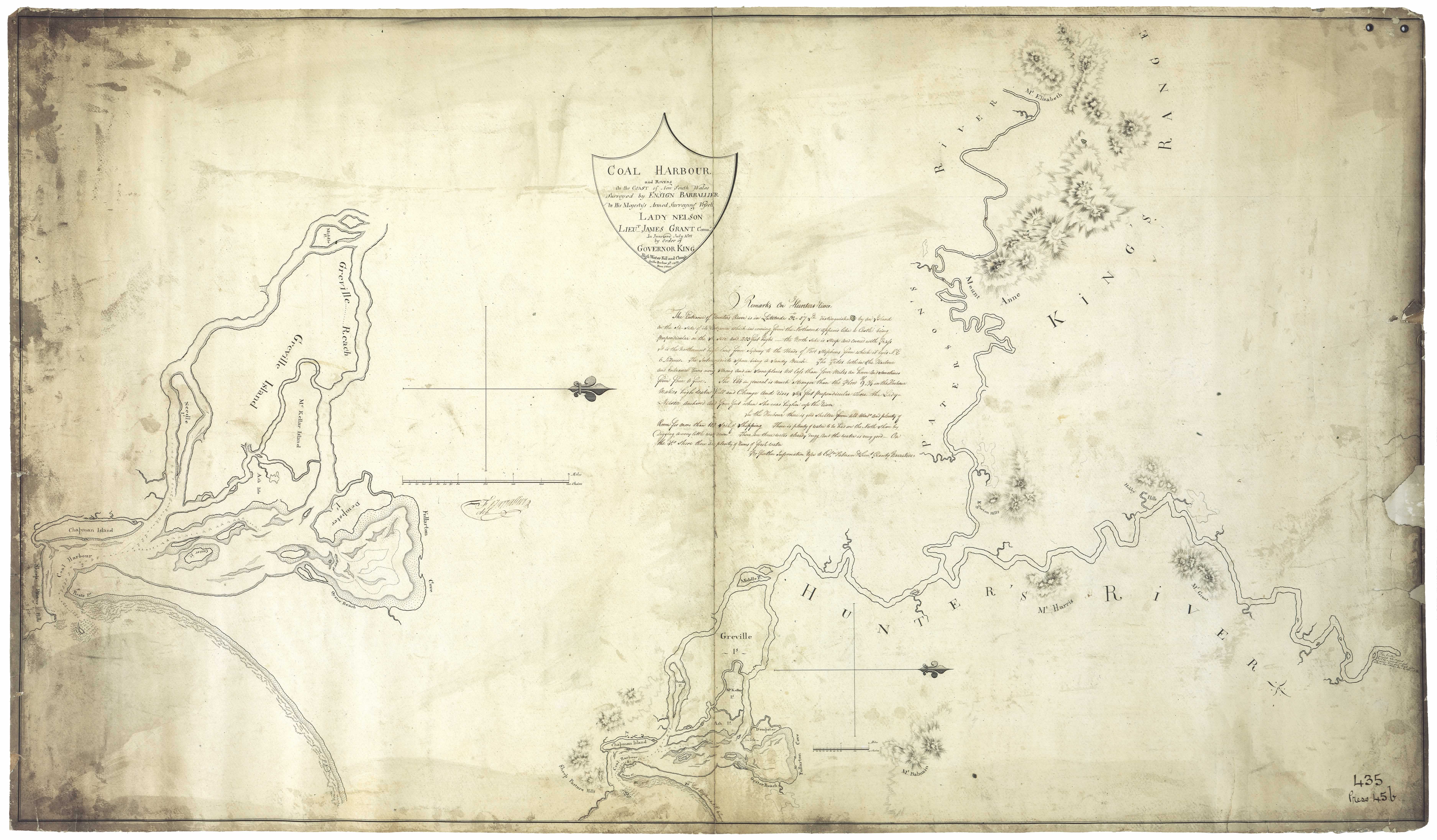
Banfield - Co. Gloucester. An agricultural settlement on the Williams River 7 miles N of Clarence Town. [37]
Bangulgully - Liverpool Plains. Station of James Evans
Bank Arcade (Maitland) - Renamed when the Rural Bank bought the premises occupied by Fosseys and a newer title created. (MM 03.04.1962 [45])
Bank Corner - 744 Hunter-street, Newcastle (Find Location)
Bank Corner Cafe - 681b Hunter-street, Newcastle (Find Location)
Bank Hotel - 235 - 237 Hunter-street, Newcastle (Find Location)
Bank Hotel - 78 Melbourne-street, East Maitland (Find Location)
Bank Street (Merewether) -Dedicated to Merewether Council in 1886 by the Merewether Estate (Dixon,J: History of Merewether [45])
Bank Street (Waratah) - Earlier name for Dawson Street. (NCC Planning Department [45])
Banks - Old Banks and New Banks - Soon after European settlement began in 1818, the name New Banks was used by some to distinguish what is now the central Maitland area from Old Banks, on the lower Paterson River and settled a few years earlier. https://maitlandstories.com.au/stories/names-of-early-maitland
Baptist Church - corner McCormick and Sidney streets, Newcastle (Find Location)
Baptist Tabernacle - Laman-street, Cooks Hill (Find Location)
Bar Beach - Area around the natural rock pool known as "The Bar" [45]
Baradine Creek. Southern tributary of the Namoi River rising in the Warrabungle Ranges. Geographical Encyclopaedia of NSW 1893
Barborah Creek. Co. Northumberland, a small tributary of the Mangrovee Creek near its source. [37]
Bareena Bay - eastern side of Coal Point.( Location on Lake Macquarie shown on 1907 - 08 Map held by Capt Deed NH Supplement 20.07.2000 p 12, [45])
Baradeen - Run at Liverpool Plains belonging to James Walker
Barfield - (Barford) Parish in county of Durham bounded on W. by Paterson river; S. by Butterwick. E. by Uffington
Barford - Parish Co. Durham bounded on N by Fingal; S. by Butterwick and E by Uffington
Barker Street, Newcastle - In honour of Bishop Barker, second Bishop of Sydney. Jesmond House situated in Barker Street. [3]
Barnard River - Northern boundary of part of Co. Gloucester. Flows into the Manning
Barney Street, Wallsend - After Barney Brown, former owner of the land through which the street runs. (Wallsend Public School Centenary 1862 - 1962 [45])
Barnier's Lane, Raymond Terrace - This unnamed lane provided access from King Street to the principal commercial wharves. In the 1880's Mr Edward Barnier was a principal storekeeper in King Street and the lane became Barnier Street about this time. (Hunter,C: History and Heritage. [45])
Barnier's Mountain (Watagans) - Named after the Barnier family who operated saw mills at Brunkerville. (NMH 15.02.1973 [45])
Barnsley - Known as Teralba until 1891. Named after a town in the coalmining district of Yorkshire, England [45]
Barokee - north of Martin's Creek. Aboriginal meaning stone (a large stone quarry situated nearby) [46].
Baromee Creek - flows in Port Stephens -Dangar's map [29]. The home of the swan (aboriginal)
Baronia Creek. Co. Gloucester. Small drainage creek flowing into Port Stephens on its northern shore. [37]
Baroona - Place far away (aboriginal meaning) - see John Larnach
Barraba - Run belonging to John Hoskinson at Liverpool Plains. 76,800 acres
Barraba - Run belonging to Esther Hughes at Liverpool Plains 20,480 acres on the Manilla River
Barraba - George Thomas Palmer, grandson of First Fleet Commissary John Palmer
Barragan - Reed bed
Barrahingbin Burraghihnbihng - A large swamp in Co. Northumberland nine miles from Newcastle known as Hexham Swamp. Used to describe part of Wallsend and including the area bounded by the Hunter River, Ironbark Creek and Mount Sugarloaf. Aboriginal name for Ironbark Creek (phonetic spelling recorded by Lieut. Close of Morpeth) [45]
Barralier Avenue, Woodberry - After Ensign Francis Louis Barralier, engineer and explorer. In July 1801 he accompanied the expedition to the Coal River (Newcastle) where he surveyed the harbour
Barralier Street, Maitland - Named for Ensign Francis Louis Barralier, as above
Barrami Creek. Co. Hunter. A southern tributary of the Goulbourn River
Barrett Street, Muswellbrook - Alderman W.Barrett, mayor 1915. (Muswellbrook Chronicle 28.01.1983 [45])
Barrington (Gloucester) After Robert Barrington Dawson, son of the first agent of the A.A. Co.
Barrington River - Named after Lord Barrington by Robert Dawson of the A.A.Co. Rises at the head of the Manning. Empties into the Gloucester river
Barrington Tops National Park - Barrington and Gloucester Tops sections of the Mount Royal Range. Approx 150 square miles
Barrow's Valley - Situated in the district of Liverpool Plains to the northward of the Peel River. Named by John Oxley after one of the Secretaries of the Board of Admiralty.
Barr Street - Merewether - Dedicated to Merewether Council in 1886 by theb Merewether Estate (Dixon,J: History of Merewether [45])
Barryowen - Pulbah Island; also Boroyirong
Barties Swamps - Area between Rosebank and Boorara - now Swan Reach. Probably named for settler Thomas Bartie
Bates Street, Hamilton North - In recognition of Ald Roger Bates of Hamilton who served on the Newcastle Council. (NMH 06.01.1976 [45])
Bath Street, Toronto - Leading to Ladies' Baths. (Clack,E: Early History of Toronto [45])
Baths Beach (Wangi) - Generic name for the southern waterfront of Wangi not in current usage. (Lake Macquarie Herald 22.03.1972 [45])
Batobato Point - Port Stephens - See Dangar's map [29]
Battens Point - Speers Point. Opposite Pippi's Hotel. Early name for the area where shipyards built ketches. (NMH 06.08.1970 [45])
Baxter Junction - Singleton shire
Bay Street, Toronto - Leading to Toronto Bay. (Clack, E: Early History of Toronto [45])
Baybuck Hill - Also Babock, Bibock, Babuck, Bubock, Bebock. Mount Royal Ranges. Upper Hunter.
Baybeg - Site of School of Arts at Morpeth (1860s)
Bayleigh - Station of George Fulford in the district Liverpool Plains NSW
Beach Cafe - 115 Mitchell-street, Stockton (Find Location)
Beach Street, Toronto - Named in honour of William Beach. (From Excelsior Parade to Kilaben Bay, now Jarrett Street). Clack, E: Early History of Toronto [45]
Beach Hotel - 99 Frederick-street, Merewether (Find Location)
Beach Hotel - Corner Watt and King streets (Find Location)
Beacon Hill - Early name for the area around Nobbys - NMH 27.07.1950
Beamadilwa - Kamilaroi aboriginal name for Bengalla estate. Also Bemadilwa [39]
Bean Street, Wallsend - After Dr. Bean, member of first committee of Wallsend Hospital, 1893; died 1916. (Wallsend Public School Centenary 1862 - 1962 [45])
Beatty Boulevade, Tanilba Bay - To commenorate the W.W.1 events in Tanilba Bay by developer Halloran (Armstrong,J:Yaccaba and Tomaree [45])
Beauford Avenue, Maryland - After a famous racehorse in keeping with the fact that the area was the former Wallsend Jockey Club's racecourse.. (Newcastle Sun 28.05.1976 [45])
Beauford Hotel - 39 Maitland Mayfield (Find Location)
Beaumont street, Hamilton - Most probably named after James or Frank Beaumont who acted as recruiment officers for the A.A.Co (Pemberton,P:Pure Merinos p 37, [45])
Bebeah - Famous vineyard of Alex Munro of Singleton from the native word Babee to sleep; Bebeah, a good place to camp or sleep
Beckett Street, Hamilton - That portion of kemp Street between Gordon Avenue to Beaumont Street. (Govt. Gaz No 86 Folio 1743 25.07.1947 [45])
Bective - (Bubbogullion)- Estate of Robert Pringle. In 1893 Co. Inglis, a small town reserve 14 miles NW of Tamworth on the Peel River. [37] Named after Lady Bective, a visitor from England. Originally call Buccatollin, aboriginal for the home of wild turkeys [46]
Bedford Street, Waratah - after Mr J.Bedford, Town Clerk 1883 - 85. (Waratah Public School Cent Book [45])
Bedham Creek. (also Bedlam) Co. Northumberland, a small tributary of the lower end of Mangrove Creek. [37]
Beebo - Liverpool Plains on the Severn river. Station of C. Abercrombie
Beggary Creek - Muswellbrook. Native name Bungarree Creek
Beith Cottage - McCormack street, Newcastle. Two doors from the Baptist Chapel 1868, off Sydney street
Belbora - Corruption of Baal Bora said to be a "place of evil", alluding to a massacre of natives. (Gilbert,L: History of Nabiac and District. [45])
Belbora Creek. Co. Gloucester. A southern tributary of the Manning River receiving the waters of the Millbrook and Baker's Creeks. [37]
Belford - A parish in Co. Northumberland NSW bounded on the N. by Hunter River E. by Black Creek, S by Parish of Ovingham and Rothbury and W. by Whittingham. Previously known as Jump-up. Named after a place in Northumberland, England [46]
Belgamba - N.E. Werris Creek - indigenous meaning, a shield [46]
Belgrave Farm - adjoined the estate of Travallyn, Paterson River
Belin - estate on Hunter River Parish of Gosforth -Dangar's Map [29]. James Thomas Lamb resided here in 1828
Bella Vista Cottage - 105 Crebert-street, Mayfield (Find Location)
Bellbird - Cessnock district. So named on account of the bellbirds which used to frequent the spot[46]
Bellevue Hotel - 738 Hunter-street, Newcastle (Find Location)
Belltrees - Named after Lord Sempill's estate in Scotland. Estate of Hamilton C. Sempill. Counties of Durham and Brisbane. 20 miles east of Scone.
Bellevue - Grant to William Evans in 1820's. On the banks of the Paterson River
Bellevue - 378 Tocal-road, Mindaribba (Find Location)
Bellmont - Estate of John William Penn Blick at Black Creek
Bell's Creek - Co. Gloucester, an eastern tributary of the head of the Hunter River. [37]
Bell's Grocery Store - 92 Elder-street, Lambton (Find Location)
Bell's Mountain - Muswellbrook area. Kamilaroi aboriginal name Millboorum. After Archibald Bell explorer and employee of Lt Col Dumaresq of St Heliers [45]
Bell Street, Muswellbrook - Probably after Archibald Bell explorer and employee of Lt Col Dumaresq of St Heliers. ( Muswellbrook Chronicle 28.01.1983 [45])
Bell Street, Waratah - After Mr Richard Bell, Alderman of the first Council. (Waratah Public School Centenary Book [45])
Belltrees - Estate named after Lord Semphill's estate in Scotland (NMH 11.12. 1954 [45])
Belmont - Named by Thomas Williamson, who settled here after his home town a village on Island of Unst in the Shetland Islands. [45] Site of the first settlement of Rev. Thelkeld known as Biddobar
Belmore Road, Lorn - After the Earl of Belmore, Sir Somerset Richard Lowry-Corry, Governor of N.S.W. (M.M 19.11.1964 [45])
Belmore Bridge - Bridge across the Hunter River at Maitland
Belmore Hotel - 476 High-street, Maitland (Find Location)
Belmore Street, Adamstown - Formerly Belmont Street (Adamstown Public School Centenary Booklet 1877 -1977 [45])
Benalla - A musk duck (aboriginal)
Bencluna - 120 Hanbury-street, Mayfield (Find Location)
Bendemeer. Co. Inglis.273 miles N of Sydney. Mountainous and gold bearing district situated on Muluerindie River near Moonbi. [37]
Bendolbah - Dungog district. Also Puntolba. (see Trove) Co. Durham. 162 miles N of Sydney. Nearest railway station Morpeth 42 miles away. [37]
Benevolent Asylum - Parry-street, Cooks Hill (Find Location)
Bengalla - Grant to Samuel Wright. Co. of Brisbane NSW. Four miles from Muswellbrook. Kamilaroi aboriginal name Beamadilwa
Bengaria - estate on the Gwydir River - Archibald Bell
Benhome - 30 Regent-street, Maitland (Find Location)
Benlarugh - Estate of Peter Sinclair - Hunters River
Bennet Street, Raymond Terrace - Street drawn up in the 1835 plan of Raymond Terrace. (Hunter, C: History and Heritage [45])
Bennett and Wood building - 363 Hunter-street, Newcastle (Find Location)
Bennett Park, Valentine - Named after Mr G. H. Bennett, former Shire Clerk of Lake Macquarie Council. (Newcastle Sun 01.03.1966 [45])
Bennetts Green - early name Rose Tree Hill
Benny's Top - Named after Benjamin Hooke one of original owners of Curracabark. This is the lowest gap in the watershed range between Curracabark Creek and Pigna Barney River
Bentham - Estate on the Wollombi or Black Brook. Dangar's Map [29]
Beresfield - Grant to William Cummings
Berkeley - located County of Northumberland NSW on shores of Tuggerah Beach.
Berico Creek. Co. Gloucester. Southern Tributary of the Gloucester River. [37] Indigenous meaning - a hollow place [46]
Berland - N. E. Raymond Terrace [46]
Bernborough Avenue, Maryland - After a famous racehorse in keeping with the fact that the area was the former Wallsend Jockey Club's racecourse. (Newcastle Sun 28.05.1976 [45])
Berner Stree, Merewether - George Berner was a tenant of Dr Mitchell and manager of Newcastle Coal and Copper Company. (C.E.Smith December 1966 [45])
Berrico - A hollow place (aboriginal meaning)
Berry Gill - Cattle run in the Gwydir district leased/owned by Robert Pringle
Berry park ( Morpeth) - Named by John Eales after his ancestral estate Berry Pomeroy Castle,in Devonshire. (Telfer, W: Wallabaddah Manuscript p188, [45])
Berry Park House - 471 Duckenfield Road Morpeth. Built in 1837 by John Eales
Bethel Chapel - 43a Dickson-street, Lambton (Find Location)
Beveridge Sawmill - Wilson-street, Hamilton (Find Location)
B.H.P. Steelworks - Waratah (Find Location)
Bibby and Tighe's Sawmill - Hannell-street, Wickham (Find Location)
Bickham Estate - Pages River. Originally Beckham after a place in Norfolk, England [46]
Biddaba - Aboriginal for Speers Point area meaning silent resting place. Name of Jonathon Warner's house
Biddobar - First settlement of Rev. Thelkeld. Belmont
Big Creek - Also known as Mirari Creek. Falling into the Allyn River near its junction with the Paterson
Big Hill Paddock - Also known as The Windella Estate on the Maitland Road near Lochinvar
Big Swamp - near Hexham; near William Sparke's land; Aboriginal name Barrhinebin or Burraghihnbihng. In 1921 called Stylesgrove after Henry Styles
Bill Curry Park (New Lambton) - In honour of Bill Curry, a former member of the Blackbutt Local Committee. (NMH 30.10.1974 [45])
Billy Baker - Situated in Liverpool Plains on a branch of the Namoi
Billy Goat Hill - Earlier name for a part of Teralba that got its name due to the fact that large herds of white goats once grazed there.They were rounded up at night and driven to properties. (NMH 15.07.1971 [45])
Bimboorien - aboriginal name for Muswellbrook (Kamilaroi) [39]. Meaning place of she-oaks [46]
Binder's Farm - Farm of Richard Binder at Patterson's Plains
Binder's Inn - 116 Hunter-street, Newcastle (Find Location)
Bingara - Co. Murchison. 352 miles N. of Sydney. Nearest Railway station Tamworth 100 miles away on the northern line. [37]
Bingara Creek. Co. Murchison. An Auriferous stream, falls into the Gwydir River. Geographical Encyclopaedia of NSW 1893
Bingera - located on the Gwydir River. Owned by George Hall
Bingle's Hill - Early name for Tighe's Hill. (Tighes Hill Public School Commemorative Booklet. 1978 [45])
Bingle Street, Newcastle - named after Captain Bingle who led a deputation to Sydney to preserve Nobbys. Captain Barney, had caused two tunnels, each about 150 ft long with chambers for explosives to be driven into the landmark, which he desird to demolish so as not to rob of the wind sailling vessels approaching the port. The name of Lieut. Sutherland is carved at the end of the tunnels where they met. Probably he was in charge of the working gangs. [3]
Binglebra - A place of thorns
Bingleburra - Paterson/ Dungog district
Binney Street, Wallsend - After F.W.Binney, secretary, Newcastle-Wallsend Coal Co., 1863-1900. (Wallsend Public School Centenary 1862 - 1962 [45])
Biriban Cave - cave on the southern side of Pulbah Island, Lake Macquarie
Bird Cage Point - Lake Macquarie
Bird Hill Farm - Upper Paterson. Farm of Richard Clarke
Bird Island - Situated off the coast of Co. Northumberland NSW; a short distance to the northward of Bungary Norah. See Dixon's map
Birdwood Park - 502 King-street, Newcastle. Named for General William Riddell Birdwood (WW1). This park was formerly known as West End Park
Birdwood Avenue, Mayfield - Curtis Street from Fawcett to Carrington Streets. (NCC Planning Department [45])
Birmingham Gardens - Newcastle suburb - First subdivided in the 1930s. Given by Mr.T.M.Burke who originally subdivided the area after the English town of Birmingham. Originally owned by Newcastle Wallsend Coal Co & sold to Commonwealth Oil Refineries. (Ella Perrett [45])
Birmingham Gardens Regal Cinema - 4 Moore-street, Birmingham Gardens (Find Location)
Birnum Wood - near Leamington. Estate of John Smith and Richard Hobden
Birralee Street, Muswellbrook - After "Birralee" built by the Hon J.C.White and later given to Brentwood Hospital for use as a nurses home. (Muswellbrook Chronicle 28.01.1983 [45])
Birriadool - Liverpool Plains [40]
Birwon - vicinity of Nord's Wharf on Henry Dangar's 1828 map. Wallarah colliery
Bishop's Bridge - After an early settler named Bishop (possibly Thomas Bishop?). Co. Northumberland, parish Allandale. Nearest railway Farley on the southern line. Geographical Encyclopaedia of NSW 1893
Bishop's Court - Morpeth. Owned by Bishop Tyrrell from 1848. Formerly Closeburne
Bishop's Court - 34 Brown-street, Newcastle
Bishop's Residence - 8 Cathedral-street, Maitland (Find Location)
Bishop's Settlement - Early name for Honeysuckle Point area, named because the Bishop of Australia once had plans to build a Grammar School on the site
Biwogkula - the place of red ti-trees; -Threlkeld[21]
Black Adams Flat - Swansea; or Adams Green
Blackbutt Reserve - Located between New Lambton and Kotara. Approx 370 acres
Black Creek - Creek on the Liverpool Plains
Black Creek - Co. Northumberland. Rises in the Broken Back range and flowing northerly empties into the Hunter River between Singleton and Maitland.
Black Creek - Early name for Branxton
Black Diamond Hotel - 371 or 375 Blane (Hunter) Street Newcastle. Building first owned by J and A Brown.
Blackboy Creek - Dungog district. Formerly known as Montyac Creek.
Blackhead Island - An island of NSW 10 miles off Port Stephens. Name given by Captain Cook as he passed up the coast to the North Head. Three small rocks lying off the coast between Port Stephens on the S and Treachery Head on the N. [37]
Black Hill - Cessnock district, Originally known as Wyabah, then The Mountain but in later years changed to the current name after aboriginal word Benwarrin meaning "long hill". (NMH 09.11.1962 [45])
Black Jacks Point - Belmont - adjacent to 16ft sailing club. Threlkeld reported that Old Jacky's tribe lived near his mission station
Black Jack Mountain - six miles from Gunnedah
Black Ned's Bay - named after ' Old Ned', King Edward White , the husband of Margaret, the last of the Awabakal tribe. This is the area near Swansea where they had their home
Black Town - Situated in the vicinity of the miners' huts near Laman Street, Newcastle
Blackall House - 22 Newcomen-street, Newcastle (Find Location)
Blackalls colliery - Fassifern
Blackalls Park: Named after Tom Blackall, a Newcastle dentist, whose father had purchased E.C.G.Chapman's estate on the promontory which became the park. (Lake Macquarie Past & Present [45])
Blackfellows' Track - Original name for Government Road, Nords Wharf. Name occurred due to the fact that it was one of the main routes used by the Aborigines to travel in the area. Name changed when residents objected to have mail addressed as such. (Lake Macquarie Herald 26.12.1968 [45])
Blacks Colliery - Cockle Creek
Blacksmiths -After an old blacksmiths forge which for many years was a landmark in the locality. (Lake Macquarie Past & Present [45])
Blairbeth - farm in the Dungog district
Blairmore - Estate of Peter McIntyre
Blairmore estate. The homestead on this estate dates back to 1836.
Blakefield Street, Muswellbrook - After the Blakefield Coal Seam, in Muswellbrook Industrial Subdivision. (Muswellbrook Chronicle 28.01.1983 [45])
Blakemore Drive, Rankin Park - President of Lake Macquarie Shire Council. (Lake Macquarie & District Historical Society feb 1970 [45])
Blandford. Co. Brisbane. 188 miles N of Sydney. Situated on the Page River and Warland's Creek about 3 miles N of Murrurundi. [37] Named after a place in Dorset [46]
Blane Street Newcastle - former name of Hunter Street between Brown St. and Cottage Ck. named after Mr. Blane - Deputy Governor of A. A. Co.
Bleardugood Farm - near Maitland in 1850
Blind Creek - Near Black Creek
Blood Tree Farm - Four miles from Newcastle in 1845
Bloomfield - (640 acres near Maitland).
Bloomfield Steet, South Maitland - After Captain Bloomfield, an early grantee at Dagworth. (MM 15.02.1968 [45])
Blue Bell Inn - Laing-street, Newcastle (Find Location)
Blue Peter Hotel - 443 Hunter-street, Newcastle (Find Location)
Blue Gum Flat - Early name for Ourimbah near Gosford. Co. Northumberland
Boarding House Dam (Watagans) Originated because it was where men camped and a bark shed was built to cook meals. Later a dam was built at the location
Boatman's Row - Nobbys-road, Newcastle (Find Location)
Boatrower's Hotel - 130a Fullerton-street, Stockton (Find Location)
Bobadil - established by the Bettington family. Located at Liverpool Plains
Bob Little's Mini Park (New Lambton) - To honour a local resident who planted trees, built benches and barbecue after winning a battle against truck drivers parking their vehicles on the land. NMH 26.04.1978 [45]
Bobs Farm - Believed to have originated with Bob, a convict stockman for an Englishman known as Gentleman Smith. (Centennary Anna Bay Public School 1879 -1979 [45])
Bogey Hole - A public baths hewn out of rock on a wave cut platform below the cliffs at Shepherd Hill Newcastle. Made by convicts for Commandant James Morisset
Boggabilla - Station on the McIntyre River in partnership of George Yeomans and Otto Baldwin
Boggabri (Aboriginal Bukkiber-i place of creeks)Co. Pottinger. 318 miles N of Sydney. Situated on the upper end of the Boco Creek about 8 miles W of Merriwa.
Boggibrie -Run at Liverpool Plains belonging to John Panton
Boggy Creek. Liverpool Plains, a small drainage creek supposed to flow into the Ghean Creek. [37]
Boggy Flat. Co. Durham. Nearest railay station Singleton, 7 miles away. [37]
Boikonumba - a place of ferns
Bold Hill - Station of W. Alison in Liverpool Plains district. 80 miles from Murrurundi
Bolton Point - earlier also known as Boughton Point. John Herring Boughton first settler. Said by some sources to have been named for Major John Charles Bolton.
Bolton Street (Newcastle) Spelled Boulton on original deeds, after Matthew Boulton, English engineer 1728 - 1809. He purchased Soho, near Birmingham 1762. He expended about 47,000 pounds helping James Watt to construct the steam engine, and took out the patent in 1769. He introduced gas lighting into Birmingham 1798.[3]
Bolwarra - View from high place (aboriginal meaning). Grant to John Brown, later acquired by Richard Jones. Co. Durham. Situated on the northern bank of the Hunter River 8 miles from Morpeth. [37]
Bolwarra House - 31 Bayswater-road, Bolwarra (Find Location)
Bolwarra War Memorial - Westbourne-road, Bolwarra (Find Location)
Bomabeg - Back of Morpeth Swamps (1860s)
Bombah Village Reserve - Area on the north of Myall Lakes that became known as Bombah Point. (Garland,H: Myall Lakes p 78 [45})
Bomi - Aboriginal name for Wallis Creek
Bomera - Run at Liverpool Plains belonging to James Hale
Bonago - Estate of John Hooke Williams River
Bonarius Lane, Newcastle - Named after J.C. Bonarius, business man of Newcastle
Bona Vista - 2000 acres granted to James Phillips. Above Tocal on the Paterson River
Bond Store Group (former) - 122 Swan-street, Morpeth (Find Location)
Bond Street, Newcastle - After Earp's Bond Store (Newcastle - Streets folder [45])
Bondaballa - Run belonging to Philip Thorley at Liverpool Plains
Bone - run at Liverpool Plains taken up by Nelson Simmons Lawson
Bone Creek - Liverpool Plains. On this stream are the stations of N.S. Lawson
Bonnells Bay - After the Bonnells family who were early settlers in the area. (Lake Macquarie Past & Present [45])
Boobadil - The station of J.B. Bettington in the district of Liverpool Plains
Booindabah Island - (Boondelbah) - Port Stephens (1826)
Boolambaye/ Boolonbayl Boolambayte - Twin lakes or two lakes (aboriginal) - Boolambago - Name used in Bailliere's Gazeteer & Road Guide 1886 to describe Boolambayte. " A small hamlet situated on the Boolambago Creek on the western border of the Myall Lakes". (Garland,H: Myall Lakes p 87 [45])
Boolaroo - Place of flies (Aboriginal meaning). Lake Macquarie
Boolaroo former Post Office - 91 Main-road, Speers Point (Find Location)
Boolladilla - On the Myall River, Co. Gloucester NSW near the lofty mountain of that name. (Bulladelah)
Booloombago. Co. Gloucester. Small hamlet on western border of Myall Lakes. [37]
Boomera - Hale's station district of Liverpool Plains 50 miles from Cassilis
Boomerang Park (Raymond Terrace) Renamed "Quarry Hill" park in honour of the author John Houlding who wrote under the name "Old Boomerang" who was a businessman in the Raymond Terrace area. (Hunter,C: History and Heritage [45])
Boomi - Aboriginal name for the junction of the Hunter River with Wallis Creek. Walsh,B: Maitland on the Hunter p13
Boonabilla Valley. Co. Durham. A deep valley lying between Mount Carrow and Cobrabald. 25 miles from Bandon Grove. [37]
Boonalla - A mountain in the district of Liverpool Plains between the Peel and Turrabeile rivers
Boondelbah Island uninhabited island lying 2 kilometres (1.2 mi) off the mouth of Port Stephens. Originally called Inch Kenneth by Governor Macquarie due to its resemblance to the island of Inch Kenneth in Argyle. (Raymond Terrace Examiner 10.07.1985)
Boongalla N. Gresford - indigenous meaning - a shady place
Boonooboonoo - (Aboriginal meaning) Kangaroo's camp - north of Tenterfield [24]
Boorabea Rd. - Wangi (aboriginal meaning native bear) - from Israel's subdivision map c. 1923)
Booragul - Summer (aboriginal). Suburb of Lake Macquarie. Grant to Madame Rens (wife of Gilbert Cory); Captain James St. John Ranclaud and James Mitchell
Boorewalla - Kamilaroi aboriginal name for Negoa [39]
Boorel (Booral)- (Aboriginal meaning: big, large) A town in Co. of Gloucester on the Karuah River. 5 miles from Stroud
Booroobulbarrowindi - Situated in County of Brisbane at Gammon Plains
Boorroomma - Run belonging to James White at Liverpool Plains
Boorambil - Joseph Onus' run at Liverpool Plains On the Oness creek, tributary of the Mooki
Booranbil/ Borambil - Creek in district of Liverpool Plains 20 miles from Gircobill
Boorumbeelah - Kamilaroi aboriginal name for St. Heliers [39]
Bootawah - Manning River aboriginal meaning - Water Rat
Booth Park (Wallsend) - Named after Mr.G.Booth M.L.A. (NMH 13.08.1952 [45])
Booth Street, Carrington - After gentleman associated with Hetton Colliery, Carrington. (Carrington Folder - Streets [45])
Borambil - Aboriginal meaning - In the vicinity of the bora ground, where the blacks meet to make men.. On the Cassilis road previously known as the old Two Mile Hollow
Boree - Singleton district
Boree Swamp. Co. Northumberland. A tract of marshy land on the Big and Little Boree Creeks 10 miles from Wollombi township. [37]
Borehole - Area of Hamilton known as the Cameron's Hill area. Previously also known as Pittown Co. Northumberland. 2 miles from Newcastle. Mining village. The Post Office at the Borehole was changd to Hamilton on 1st August 1872
Borehole Colliery - Cockle Creek
Borongo - In district of Liverpool Plains; station or R. Pringle
Borough Markets - Hunter-street, Newcastle (Find Location)
Boroyirong - Pulbah Island
Borringargul - Wyong Creek (NSW Atlas of settled areas)
Boughton's Point - Bolton Point
Boun - Aboriginal name for Wallis Plains; from a bird of that name' -Threlkeld [21]
Boundary Street, Merewether - Portion of Railway Street between Mitchell and Morgan Streets. (NCC Planning Department [45])
Boundary Street , Wallsend - Due to the fact that the street marks the old boundary of Wallsend and Plattsburg. (Wallsend Public School Centenary 1862 - 1962 [45])
Bourke Street, Carrington - Lt Gen Sir Richard Governor in Cheif N.S.W. 1831 - 1837. Patron of the first Mechanics Institute. (Carrington Folder - Streets [45])
Bourke Street, Maitland - After Major General Sir Richard Bourke , who was a governor of NS.W. (MM 19.11.1964 [45])
Bousfield Street, Wallsend - After T. Bousfield, first secretary, Wallsend Co-operative Colliery. (Wallsend Public School Centenary 1862 - 1962 [45])
Bow - Co. Brisbane. 235 miles N of Sydney. Nearest railway Muswellbrook 57 miles. [37]
Bow Creek - Estate of Charles Blaxland, Cassilis
Bowen River - District of Liverpool Plains; rises near Pandora's Pass and falls into the Turrabeile at its junction with the Yorke river; Names by John Oxley in honour of Commissioner Bowen of the Navy Board
Bowfield Place, Muswellbrook - After a property owned by M.M.Bowman in the Saddlers Creek area. (Muswellbrook Chronicle 28.01.1983 [45])
Bowling Alley Point - Gold diggings near Nundle. Co. Parry. Situated on the Peel River. Nearest railway Tamworth. [37]
Bowman - Co. Gloucester. township. 177 miles N of Sydney on the Bowman River a tributary of the Manning River. [37]
Bowman (Gloucester) After a shepherd employed in the early days of the A.A.Co. (NMH 24.12.1953 [45])
Bowman's Creek (Singleton) After Dr. James Bowman, who in the 1840's owned the Ravensworth Estate.
Bowman Park (Muswellbrook) Given to the people of the town by Edward Bowman of "Skellatar". (Muswellbrook Chronicle 28.01.1983 [45])
Bowman Street, Muswellbrook - Alderman E.Bowman & W.R.Bowman, both former mayors of the city. (Muswellbrook Chronicle 28.01.1983 [45])
Bowtell Brickwords - 2 Margaret-street, Merewether (Find Location)
Bowthorne estate - On the Paterson River, Parish Butterwick, four miles from Maitland. Estate of Alexander Livingstone
Bow Wow Creek - Adjacent to the Wollombi catchment on the eastern boundary near Mulbring
Box Beach (Port Stephens) Due to the fact that the rocks flanking the beach appear a box like shape. (Port Stephens Historical Society 06.12.1969 [45])
Box Farm - Jerrys Plains
Box Tree Clearing - Singleton district
Boyce's Point - Fennell Bay
Boyen - Aboriginal name for West Maitland (1860s)
Braeside - 37 Lorna-street, Waratah (Find Location)
Braithwaite Head - Name given to Fort Scratchley, Newcastle by Lt John Shortland in 1797. Named after Lieutenant Robert Braithwaite of H.M. Reliance
Bralga - N. W. Gloucester - also a native companion (bird) [46]
Bramcote - Barnsley/Teralba - An estate offered for sale by Bonarius adjoining Flaggy Creek consisting of Coolege, High,King, Queen,Prince, Victoria, High Cross streets and Main and Minmi roads. (Vertical file LHQ919.442/TER [45])
Branch Creek. Co. Brisbane. Western tributary or head of the Hunter River. [37]
Brandon - Grant to John Wighton. Williams River
Brandy Hill - William River district
Branxton - (village) After a place in Northumberland, England. Situated Co. Northumberland on Anvil Creek between Maitland and Singleton. The original name of Branxton was Farmborough. Later it was known as Black Creek. Branxton (Parish) Co. Northumberland bounded on N. by the Hunter River; on E. by parish of Gosford; on S. by Allandale and W by Black Creek to its confluence with the river Hunter
Brass Water. Co. Gloucester. A noble sheet of water at the head of the Myall River above Port Stephens.
Braemer - 105 Church-street, Newcastle (Find Location)
Bramley Court - 7 Bingle-street, The Hill (Find Location)
Bray Farm - Allyn River
Braye Park (Waratah) Named after Ald Braye - during his term as Mayor of Waratah the land was dedicated as a public reserve. Established in 1898 after grant to the local council of land by the Braye family. (NMH 01.07.1914. [45])
Braye Street, Waratah - After Mr T.A. Braye, Mayor 1902 - 03. (Waratah Public School Centenary Book [45])
Brecht Street, Muswellbrook - Alderman E.C.Brecht a former mayor of the city prior to 1902. (Muswellbrook Chronicle 28.01.1983 [45])
Breckenridge Drapery - corner Hunter and Auckland streets, Newcastle (Find Location)
Breckenridge Timber and Commission Agent - 31 Hunter-street West (Find Location)
Breckenridge Blue Room Cafe - corner Hunter and Auckland streets, Newcastle (Find Location)
Brecon Farm - Paterson
Breekin Mount - Co. Durham. A high hill lying S.E of Gresford at a distance of 4 miles. [37]
Breen Park (Stockton) This park could take its name from Ald. Thomas Emmett Breen, a deputy lord mayor of Newcastle & leader of the ALP. He was a resident of Stockton. (NS 15/03/1965 [45])
Breeza - Run at Liverpool Plains taken up by Andrew Lang. Indigenous meaning, fleas, place of flease. Corruption of biridja
Brennan Park (Muswellbrook) After Fr James Brennan, Parish Priest of St James Roman Catholic Church in 1970's. Part of the land bought by the Church from the Bowman estate. (Muswellbrook Chronicle 28.01.1983 [45])
Brentwood Street, Muswellbrook - After Dr Robert Griegson's private residence later acquired for Public Hospital from the Griegson Estate. (Muswellbrook Chronicle 28.01.1983 [45])
Brett Street, New Lambton Heights - Named after Mr Brett, manager of the Dangar Estate (NMH 23.07.1953 [45])
Bretti - indigenous meaning - a round swamp [46]
Brettville - 1500 acre estate on Dora Creek at Cooranbong. Estate of William Brett 1892. Known as Campbell's grant.
Brickmaker's Arms - Mary-street, Merewether (Find Location)
Brickworks Park (Wallsend) Created in the old Wallsend Brickpit on Newcastle Road. (NMH 22.05.1986 [45])
Brickwoods Ridge - Below Buckles Range -Dangar's Map [29]
Bridgeman Bridgman Park- Thomas Clarkson's grant later acquired by Robert Lethbridge and managed by Richard Alcorn. Located at Falbrook. Co. Northumberland. Named by John Lethbridge after Bridgman Park in England, later shortened to Bridgman [46]
Bridge Street, Muswellbrook - Originated from the construction of a bridge over Stanley Creek (more commonly known of as Possum Gully). (MUHHS: A History of Muswellbrook [45])
Brien Street, The Junction After the Brien family (Newcastle - Streets folder [45])
Brighton Hotel - 70 Scott-street, Newcastle (Find Location)
Brightwaters - Name given at time of subdivision. (Lake Macquarie Past & Present. [45])
Brindley Park - Estate belonging to the Bettington family. Situated Co. Brisbane between Gummum and Bow Creeks. Merriwa
Brinkburne House - Residence of George Thomas Fenwick in 1849. Gresford
Brisbane - County of NSW. Towns Murrurundi, Haydonton, Scone, Merriwa, Cassilis, Invermein, St. Aubins
Brisbane Road, Broadmeadow - Portion of Griffiths Road between Jackson Street and Turton Road. (Gov Gaz No 168 19.12.1975 [45])
Brisbane Street, East Maitland - After Col Brisbane, an explorer of early N.S.W, after who the City of Brisbane was named. (MM 19.11.1964. [45])
Brisbane Water - Police district of NSW Bounded on the N. by a line from Reid's Mistake across Lake Macquarie, bearing westerly to Dora Creek and by Dora Creek to the Warrawolong range; on W. by crest of Mount Warrawolong range to Mount Simpson and by the north road to Wiseman's Ferry; on S by the Hawkesbury and Broken Bay roads to Box Head. (1848)
Brisbane Water - Harbour of NSW in Co. Northumberland. Principal streams that flow into are Erina and Narrara creeks. (1848) named after Sir Thomas Brisbane, Governor 1821-25. Early name for the Gosford area.
Brisbane Water Road, Adamstown - Earlier name for a portion of the current Park Avenue between Court and Dibbs Streets.Also changed to Northcotte Drive in 1957. (Gov Gaz No 217 Folio 3577 25.11.1949 [45])
Brisbanefield - Grant to James Kelly Hunter River
Brisbanegrove - Grant to George Williams, Paterson River
Britannia Hotel - corner Kenrick and Union streets, Cooks Hill (Find Location)
Britto - Gloucester region. Indigenous meaning hilly, stony [46]
Broadmeadow Farm - Thomas Groves early resident. Broadmeadow was part of the Newcastle Pasturage Reserve of 648 hectares. It developed around the Great Northern Railway, the road to Newcastle’s western suburbs and the construction of the Sydney to Newcastle Railway in the 1880s
Broadwater. Co. Gloucester. An expansion of the Myall River forming the S. portion of the sheet of water known as the Myall Lake.
Broadwater, The. Co. Northumberland. Name applied to Brisbane Water Harbour.
Broadway Hotel - corner Brown and Lambton roads, Broadmeadow (Find Location)
Broadmeadow Aerodrome - 2 Denney-street, Broadmeadow (Find Location)
Broadmeadow Locomotive Depot - Broadmeadow (Find Location)
Broadmeadow Racecourse - 100 Darling-street, Broadmeadow (Find Location)
Broadmeadow Racecourse Caretaker's cottage - Lowe-street, Broadmeadow (Find Location)
Brogden's Pinnacles (Stroud) Named after one of the A.A.Co directors. (Pemberton,P: Pure Merinos p 111 [45])
Brogden's River - Flows into the Stroud River -Dangar's Map [29]
Brogheda - Originally the name of a property about 15 miles outside of Muswellbrook on the tributory road from the main road to Aberdeen. Turn off is just past the present Dairy Factory. (Harry Boyle [45])
Broke - Named by Sir Thomas Livingston Mitchell, Surveyor-General after Sir Charles Broke Vere. - County Northumberland in Wollombi Brook
Brokenback Range - A mountain of NSW situated Co. Northumberland to the S.W. of Maitland. Portion of the Watagan Mountains out back of Broke. (Clouten,K: Reid's Mistake. [45])
Broken Pot Creek. The Gwydir. a small arm of the Mooni Creek draining swampy land to the W. of Burrandon. [37]
Bronte Crescent, Muswellbrook - Named by Reg Osborn after his wife Joyce's birthplace - a property "Bronte" near Goulburn, N.S.W. (Muswellbrook Chronicle 28.01.1983 [45])
Brookfield - Co. Durham on Williams River 7 miles from Clarence Town. Estate of Charles Smeathman and later Brent Clement Rodd; occupied by Edwin Hickey in 1848
Brook Lodge - on Wollombi Brook -see Dangar's Map[29]
Brooks Flat - Early name for the area now known as Buchanan, after George Brooks who had the original land grant. (Hartley,D: Settlers of the Big Swamps [45])
Brooks' Mountain - Early name for Munibung Hill, Lake Macquarie (William Brooks, early grantee)
Brooks Street (Cooks Hill) Named after George Brooks, Govt. Medical Officer in Newcastle 1823 [3]
Brooks Street, Wallsend - After George Brooks early settler in Wallsend or J.W. Brooks, first secretary Wallsend Coal Co. Now Richardson Street and covered portion between Wentworth and Macquarie Streets. (Wallsend Public School Centenary 1862 - 1962. [45])
Brookstown - Early name for Wallsend after Dr William Brooks. Also the name for a colliery operated by Mr Andrew Sneddon from 1884 till 1890. (NMH 04.07.1950 & NH 22.04.1924 [45])
Broomfield - Grant to James White at Pages River
Brothers - The old name of the place said to be the name given by the blacks to a species of ant and named in consequence of the large number there. [40]
Brough House - 73 Church-street, Maitland (Find Location)
Brougham - parish in Co. Durham bounded on N. by Rowan, W. by Hunter River and S. by Vaux
Broughton House - 37 Church-street, Newcastle (Find Location)
Broughton Island (off Port Stephens) - After Captain W.R. Broughton of H.M.S. Providence, who in August 1795, sought shelter in Port Stephens. Opposite the headland known as The Gibbers.
Brown Muir - Wollombi - The estate of Thomas Crawford
Brown Sisters' Convent - 8 Janet-street, Merewether (Find Location)
Brown St. Newcastle - Named after Captain Samuel Brown, naval officer and bridge builder (England)[48]
Brown Street School - Brown-street, Newcastle (Find Location)
Brown's Brush - vicinity of Bolwarra
Brown Street, Adamstown - Named after long serving Town Clerk for Adamstown Council, Mr.W.Brown (Adamstown Public School Centenary Booklet 1877 -1977 [45])
Brown Street, Dungog - Named after early grantees in the region. (Bennett,C: History of Dungog,Chichester & Wangat [45])
Brown Street, Newcastle - After Alexander Brown, Colliery Manager for the A. A. Co. in 1836 (F. A. Cadell Newcastle - Streets folder [45])
Brown Street, Wallsend - After Alexander Brown, a director of the Newcastle Wallsend Coal Company. (Wallsend Digest 29.08.1963 [45])
Browne's Waterfall (Watagans) - After an early settler called Browne. (NMH 01.09.1973 [45])
Bruce Street, Cooks Hill - C.D. Bruce - Director of A. A. Co. (Newcastle - Streets folder [45])
Brunker Road, Adamstown - Formerly called Union Street, north of Victoria Street and Charlestown Road, south of Victoria Street. (Adamstown Public School Centenary Booklet 1877 -1977 [45])
Brunkerville - Named after James Nixon Brunker, M.L.A. Cessnock district.
Brush Farm - 30 acre farm of John Eckford at Wallis Plains established 1818
Brushy Hill. Co. Brisbane. Nearest railway station Aberdeen 7 miles away. [37]
Bryant Street, Adamstown - Named after the Bryants, owners of the original subdivision after the land grant was sold by Thomas Adam. (Adamstown Public School Centenary Booklet 1877 -1977 [45])
Byrn Glas - 16 Elizabeth-street, Telarah (Find Location)
Brynhfryd - 44 Kilgour-avenue, Merewether (Find Location)
Bubbah-Bubbah Swamp. Co. Northumberland. A tract of flat swampy ground near Stingaree Point, at the fall of the Dora Creek into Lake Macquarie. [37]
Bubbogullion - Attunga Creek - Liverpool Plains Cattle run leased by Robert Pringle
Buchan - aboriginal name meaning large rock or stone. Also known as The Buckets - Barrington Tops
Buchanan - named after David Buchanan, Parliamentary member for Morpeth 1860. Situated Co. Northumberland parish of Stockrington near Maitland on Wallis Creek; property of George Brooks in 1848. Also known as Brook's Flat
Buchanan Street Newcastle - named after Henry Buchanan Mayor Newcastle [3]
Buchanan Terraces - 10 - 30 Church-street, Newcastle (Find Location)
Buckawackah - Manning River aboriginal name meaning To Crawl on the Hands and Knees
Buckawauka - E. Gloucester, indigenous meaning - to lie down with the knees up [46]
Buckets (Gloucester) From Buckan, the Birpai and Kattang word for stone. (Gilbert,L: History of Nabiac and District. [45])
Bucklebone - station of Brown and Selwyn in district of Liverpool Plains on the Namoi River
Buckles Range - Between Harrington and Stroud Rivers. Dangar's map[29]
Buckley's range - Area between Mill Creek and Mammy Johnson's River, named after a former employee of the A.A.Co. 9 Pemberton,P: Pure Merinos p 111 [45])
Buckut - Manning River aboriginal name meaning A Stone
Budden's Lane, Muswellbrook - After Mr Frank Budden, a tailor who lived in a two storey house in Sydney Street. (Muswellbrook Chronicle 28.01.1983 [45])
Buddle - River, branch of the Namoi district of Liverpool Plains
Budgewoi - Aboriginal - softbark tea -tree (NMH 23.04.1955 [45])
Bugaldi - Run belonging to Charles Fitzsimmons at Liverpool Plains
Bulahdelah. Co. Gloucester.. Also Bulladelah. Indigenous name Kurrahboolya
Bulba - Aboriginal name for an island; any place surrounded with water - Threlkeld [21]
Buhlbah - Awabakal name for Pulbah Island - Dangar map [29]; also Boroyirong
Bulbararing Lake. Co. Northumberland. A small lagoon or inlet of the sea, about 1 mile square, and having a sand bank or island in its centre. The N. part of the lake is called Moore's Lagoon, about 2 miles E of Kincumber. [37]
Bulga - (Balgarr) A single mountain (aboriginal). Singleton district
Bulgarrie - Run belonging to Joseph Moses at Liverpool Plains
Bulga Road (now known as Putty Road)
Bulga Farm - Cockfighter's Creek, Mr. Cobcroft
Bulgonia - former name of Brightwaters
Bulkara - Aboriginal name for mountain; from bulka 'the back' of a man or a beast
Bull - Run belonging to Thomas Parnell - Liverpool Plains
Bull Street, Mayfield - Industrial Drive from Arthur, Ingall and Vine Streets NCC Planning Department [45])
Bull Street Newcastle, Named after Captain John Edward Newell Bull, Govt Superintendent of Works 1836 [3]
Bull Street Extended (Newcastle) That portion of Nesca Parade between Brooks Street to Kitchener Parade. (Gov gaz 03.04.1933 [45])
Bulladelah - A big Creek
Bullahdelah Mount. Co. Gloucester. 6 miles by bush track from the township of Bullahdelah. Geographical Encyclopaedia of NSW 1893
Bulla Delah - Manning River aboriginal name for two big rocks
Bullal - Dry creek
Bullecourt Street (Shoal Bay) Named after a famous battle on the Western Front in the 1914 - 18 war. (Port Stephens Examiner 26.04.1989 [45])
Bullee Noyden - also Bullen Agglen. Rock near Bungaree Norah (Norah Head). Also known as'The Bull'. The Ceres paddle steamer wrecked there in 1836
Bulliac - N. Gloucester - indigneous meaning - a bend in the river [46]
Bullock Island - also known as Corrumbah, Chapman Island, Onebygamba and Carrington. Co. Northumberland, Hunter River. Separated from the mainland by a narrow channel called Throsby's Creek. On the NW point of the Island was the quarantine ground for port of Newcastle. [37]
Bullock Island Colliery - 8 Cowper-street, Carrington (Find Location)
Bull's Creek - Gateshead
Bumalong point - The site of a small settlement that waned as Minmi grew. (Hartley,D:Settlers of the Big Swamp p 50 [45])
Bundabah - Named after the A.A.Co Bundabah Run located on the Bundabah Creek. (Engel,B: Tea gardens - Hawks Nest p69 [45])
Bundabah - Place of kangaroo (aboriginal)
Bundanbing Brook - parish of Stanhope
Bundabarrbarina - a cattle station fifteen miles below Pokataroo. Liverpool Plains [40]
Bundarra - town is located on Thunderbolts Way and on the banks of the Gwydir River, in the Uralla Shire. (Kamilaroi meaning grey kangaroo)
Bundarra River - Also known as Rocky River and Gwydir River [40]
Bundee, Bondee - Toronto - Coal Point peninsula on early maps
Bundobollah - station of P. Thorley in district of Liverpool Plains
Bunduckaluck - mountainous range in Co. Durham near Vacy. See Dangar's map [29]
Buneewa - Kamilaroi aboriginal name for Merton estate [39]
Bungalaben Mount - Co. Northumberland. a peak in the Hunter Range about 18 miles SE of Wollombi.
Bungaree Bay - A cattle station of Colonel Snodgrass in Co. Gloucester
Bungaree Norah - (Norah Head) Point of land near Tuggerah Lakes Co. Northumberland 90 miles from Sydney
Bungaree Street, Telarah - After King Bungaree, an aboriginal who came here with the first party of surveyors. (MM 15.02.1968 [45])
Bungwahl - Manning River aboriginal meaning - The root of a Swamp Fern sometimes called Uki
Bungwall Flat. Co. Gloucester. 169 miles N of Sydney. [37]
Bunn Street, Wallsend - Probably after George Bunn proprietor of a bus running between Newcastle and Wallsend before a regular passenger train service. (Wallsend Public School Centenary 1862 - 1962. [45])
Bunnalong Swamp. Co. Northumberland. A tract of swampy ground on the N. bank of the Dorah Creek near Singaree Creek. [37]
Bunnan - Ashes (aboriginal). Co. Brisbane. 187 miles N of Sydney. Nearest railway station Scone 20 miles away. [37]
Bunns Crossing ( Lambton) Route that formed the boundaries of Lambton and Waratah Councils and used as a popular route to travel north to south. Named after Betty Bunn and site of present Lambton Road. (Gregg: Suburb of Lambton p 8 [45])
Bunyah - Manning River aboriginal word - An Opossum
Burburgate - Run belonging to W.C. Wentworth at Liverpool Plains
Burburra Burburra - Kamilaroi aboriginal for Pickering estate [39]
Burdekin Park (Singleton) After the Burdekin family, who in 1878 donated the land which had been given as a Market Reserve by Bennjamin Singleton. (Singleton Municipality & Shire 1866 - 1991 [45])
Burgman House - 4 Pitt-street, Mayfield (Find Location)
Burlington - N. W. Maitland - named after Burlington's Ltd., th owners of the local mill [46]
Burragurra Mount. Co. Northumberland. A peak in the Hunter Range, parish Lockyer, about 14 miles SSW of Wollombi. [37]
Burrell - station of Thomas Parnell district Liverpool Plains on the Namoi River
Burrell - Dungog district (1841)
Burrill - Manning River aboriginal name meaning yellow
Burrill Creek. Co. Gloucester. A small tributary of the Manning River. [37]
Burreen Creek - also known as Greig's Creek Upper Hunter. Near the estate of James Greig.
Burrenburren - district of Liverpool Plains. Station of John Eckford
Burrinbingon/ Burrabihngarn - Aboriginal name for Pirate Point/ Stockton meaning a land of plenty with food in abundance.
Burroull - Williams River. Estate of George Mossman
Burrundulla - Pitt-street, Mayfield (Find Location)
Burwood. Co. Northumberland. A village near Hexham on the road and railway between Newcastle and Maitland. [37]
Burwood Copper Smelter (Find Location)
Burwood Estate - Merewether - Newcastle - Copper smelter developed by James Mitchell 1846. Original name of Glenrock Lagoon
Burwood Inn - 77 Berner-street, Merewether (Find Location)
Burwood Street, Merewether - After the original name of the Estate. (Dixon,J: History of Merewether. [45])
Burwood Street, Newcastle - Named from the railway line from the Burwood Estate (NHDHS Journal Vol 8 p 73 [45])
Burying Ground, The - Governor Macquarie in his 1812 visit to the Maitland district called the area The Burying Ground or Schank's Plains.
Busby's Creek - Also known as Carrow Brook, Carro Creek, Carrocreek (Mitchell's map). Upper Hunter.
Bush Road, Waratah - Early name for portion of High Street between Bridge Street to Turton Road.( NCC Planning Department. [45])
Buttaba - village on Lake Macquarie (aboriginal for the name of a hill on the margin of the Lake - Threlkeld[21]
Buttaba Hills - Henry F Halloran named his 1920 subdivision Buttaba Hills
Butterembutt Island - Port Stephens - Dangar's map [29]
Butterwick - Parish in Co. Durham bounded on N. by Bradford, on E. by Seaham and Uffington; W. by the Paterson River and S. by the Hunter River. 8 miles from Maitland. Named after a place to the south west of Hull, England [46]
Butti - More, continue the action (aboriginal). Cessnock district NMH 11.12. 1954 [45]
Buttonton - district of Murrurundi
Notes on the Origins and Locations of the Hunter Region has been derived from the following sources
[1] Trove - National Library of Australia
[2] Newcastle Morning Herald 11 December 1954
[3] The Newcastle Sun 2 May 1918
[4] The Newcastle Sun 26 January 1931
[5] The Many names of Newcastle Mulumbinba
[6] The Muswellbrook Chronicle 8 November 1899 ( native names of place from black tracker Jimmy of Muswellbrook)
[7] Lake Macquarie History of Places
[8] Cadell, F.A., Survey of Newcastle, Journal and Proceedings of the Royal Australian Historical Society, 1936
[9] Davies, Noel, Convict Nobbys : the story of the convict construction of Macquarie's Pier and the reconstruction of Nobbys Island
[10] Historical Roads of New South Wales
[11] Keith H. Clouten, Reid's mistake : the story of Lake Macquarie from its discovery until 1890
[12] County Electors in Newcastle 1855
[13] Hunter Estates Comparative Heritage Study
[14] The Dungog Chronicle 6 July 1949
[15] The Scone Advocate 24 July 1894 (Muswellbrook names)
[16] Wingham Chronicle 13 November 1931 (Manning River places)
[17] King Tom's Aboriginal Geography in Memorandum of E.C. Close, in Australian Town and Country Journal, 12 January 1878, p. 8.
[18] Aboriginal names, Australian Town and Country Journal 11 January 1879p. 17
[19] Henry Thomas Ebsworth papers, June 1825-February 1827; with illustration and maps
[20] Horsemen of the First Frontier (1788-1900) and the Serpent's Legacy Front Cover Keith Robert Binney
[21] An Australian Language as spoken by the Awabakal, the people of Awaba, Lake Macquarie, being an account of their language, traditions and customs - Lancelot Threlkeld (many of the aboriginal terms above have come from this source which is probably the language of the lower Hunter tribes)(many of the aboriginal terms above have come from this source which is probably the language of the lower Hunter tribes)
[22] Hunter Living Histories - Ludwig Leichhardt in Newcastle
[23] A geographical dictionary or gazetteer of the Australian colonies ... By William Henry Wells
[24] Placenames as a guide to language distribution in the Upper Hunter - Jim Wafer
[25] Lake Macquarie : past and present
[26] Wangi Wangi Street Names by Clive Read
[27] Forgotten place names of Lake Macquarie - Lake Macquarie Library online
[28] Lake Macquarie: Parish of Awaba, County of Northumberland, Shire of Lake Macquarie. Parish map in 4 sheets and reference sheet: South East Sheet
[29] Map of the Hunter River and its branches by Henry Dangar 1828
[30] Robert Dixon's 1837 Map - Trove
[31] Ensign Francis Barrallier's Map 1801 - Hunter Living Histories
[32] Australian Town and Country Journal 22 November 1873
[33] Procter's Sketch 1841 - Hunter Living Histories
[34] Tegg's Pocket Almanac
[35] Map of Young Wallsend (Edgeworth) showing Salty Creek Recreation Area, c.1920. Scanned from: Road and tourists' map of Lake Macquarie and environs, H. E. C. Robinson Limited, Sydney.
[36] Salty Creek Recreation Area
[37] Geographical Encyclopaedia of New South Wales
[38] Atlas of the settled counties of New South Wales - State Library NSW
[39] Maitland Weekly Mercury 4 July 1896
[40] Empire 3 Dec 1853 Lecture on the Kamilaroi Blacks (Rev. William Ridley)
[41) Israel's subdivision map of Wangi c. 1923. State Library of NSW
[42] Hunter 2000, National Trust of Australia (NSW), 1973
[43] Lauchland, E. S., Homes we Visited - Dumore. Newcastle & Hunter District Historical Society Journal, 1947 p. 39
[44] Boyle's Lower Hunter index, 1801-1883 (Harry Boyle)
[45] Hunter Valley Place Names and their Meanings, Newcastle Library, Archived 14 June 2011 at the Wayback Machine
[46] Toponomy: Place Names of New South Wales: Their Origin, Meaning and Locality, compiled by J. Carlos W. Stretch
[47] Rediscovering the Coquun: towards an environmental history of the Hunter River. Address given at the River Forum 2000 at Wyndham Estate, Hunter River; by Glenn Albrecht PhD, Senior Lecturer in Environmental Studies, The University of Newcastle
[48] How Many Inventors? Russell Rigby, Hunter Living Histories, 10 October 2017
↑